Eureka AIR delivers breakthrough ideas for toughest innovation challenges, trusted by R&D personnel around the world.

Open-pit mine mining and stripping quantity calculating method utilizing plane image aerial-photographing

A technology of aerial photography and calculation method, applied in calculation, image data processing, data processing application, etc., can solve problems such as long data processing cycle, normalized work flow of new mine surveying technology, long measurement cycle, etc.

Inactive Publication Date: 2015-02-25
ANSTEEL GRP MINING CO LTD
View PDF2 Cites 22 Cited by
  • Summary
  • Abstract
  • Description
  • Claims
  • Application Information

AI Technical Summary

Problems solved by technology

Due to the continuous mining, the topography of the open-pit mine changes rapidly, and because the mining and tailings accumulation are carried out at the same time, the topography changes are also complicated
At present, the measurement technology of mining stripping in open-pit mines at home and abroad is still based on total station, GPS single-point measurement and rough statistics, which requires a lot of manual field work, long measurement cycle and long data processing cycle
The latest aircraft aerial photography measurement technology is developing rapidly, and good test results have been achieved, which proves that this type of new technology can significantly improve the measurement work efficiency, but there are still some technical achievements for mine measurement that need to be explored and researched, and no new technology for mine measurement has yet been formed. Normalized work business process

Method used


Image

  • Open-pit mine mining and stripping quantity calculating method utilizing plane image aerial-photographing
  • Open-pit mine mining and stripping quantity calculating method utilizing plane image aerial-photographing
  • Open-pit mine mining and stripping quantity calculating method utilizing plane image aerial-photographing

Examples


Embodiment Construction

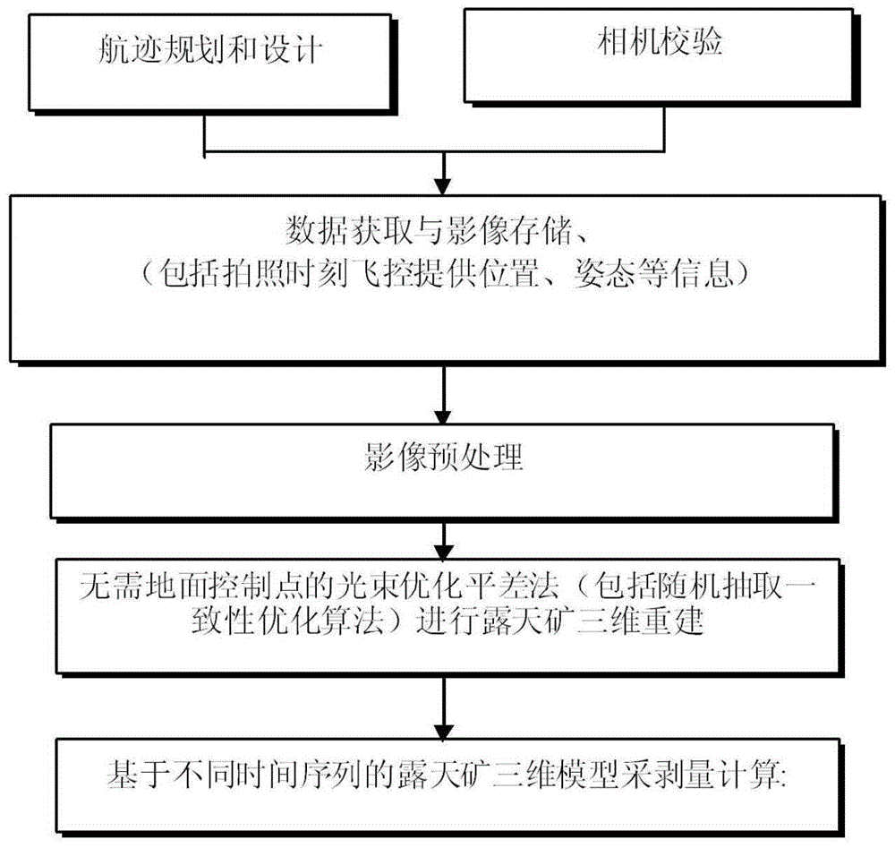
[0029] The specific implementation manner of the present invention will be further described below in conjunction with the accompanying drawings.

[0030] The open-pit mine stripping amount calculation method utilizing aircraft aerial images of the present invention is characterized in that it comprises the following steps:

[0031] A) Mission planning: According to the geographical conditions of the open-pit mine, plan and design the flight path of the aircraft; check and calibrate the digital camera carried by the aircraft, and measure the focal length, principal point, and pixel size parameters of the camera;

[0032] B) Data acquisition: Control the aircraft equipped with a digital camera to take off at a flight altitude of 100-500 meters; control the digital camera to take aerial photography, set the focus mode to autofocus, and the shooting mode to continuous automatic shooting to ensure that the sequence of images overlaps along the course ≥ 60%, side overlap ≥ 40%, ima...


PUM


Abstract

The invention belongs to the technical field of mine production management, and particularly relates to an open-pit mine mining and stripping quantity calculating method utilizing plane image aerial-photographing. The method includes utilizing plane image aerial-photographing technology; performing plane flight path planning and designing according to geographic conditions of an open-pit mine; checking a digital camera carried by a plane; controlling the digital camera for aerial photographing and image acquiring and storing at the same time; recording plane position and posture information provided during photographing; building an open-pit mine earth surface three-dimensional point cloud model. The open-pit mine earth surface three-dimensional point cloud model can be built without adopting a bundle adjustment method of control points, an open-pit mine earth surface irregular triangular net model is built, mining quantity and rock discharging quantity are automatically measured and recorded, accumulated volume values of the open-pit mine earth surface triangular net model at different times are subtracted to accurately calculate earth-rock quantity of an excavating or backfilling body, calculating of open-pit mine mining and stripping quantity is realized, open-pit mine measuring work efficiency is improved, and statistical accuracy of mining and stripping quantity is improved.

Description

technical field [0001] The invention belongs to the technical field of mine production management, and in particular relates to a method for calculating stripping amount of an open-pit mine by using an aerial image taken by an aircraft. Background technique [0002] At present, the country is carrying out research on geographic national condition monitoring, and mine survey and mine condition monitoring in open-pit mines are one of the important directions. Due to continuous mining, the topography of open pit mines changes rapidly, and because mining and tailings accumulation are carried out at the same time, the topography changes are also relatively complicated. At present, the measurement technology of mining stripping in open-pit mines at home and abroad is still based on total station, GPS single-point measurement and rough statistics, which requires a lot of manual field work, long measurement cycle and long data processing cycle. The latest aircraft aerial photograph...

Claims


Application Information

Patent Timeline
Patent Type & Authority Applications(China)
IPC IPC(8): G06T17/05G06F19/00G06Q50/02
CPCG06T17/05
Inventor 汪忠海陶东海王植徐白山陈国岩刘志龙
Owner ANSTEEL GRP MINING CO LTD
Why Eureka
Eureka Blog
Learn More