A self-adaptive multi-terminal visualization method for geospatial information

A geospatial information and self-adaptive technology, applied in geographic information databases, special data processing applications, electronic digital data processing, etc., can solve problems such as incomplete application, neglect of individual needs, backward research on individual services, etc., and achieve easy-to-use functions , friendly interface effect

Active Publication Date: 2018-09-11
武汉图歌信息技术有限责任公司
View PDF4 Cites 0 Cited by
  • Summary
  • Abstract
  • Description
  • Claims
  • Application Information

AI Technical Summary

Problems solved by technology

For the adaptive processing and service of geospatial data, due to the particularity of spatial data and spatial data processing, conventional cloud computing technology is not fully applicable. There are still adaptive carrier transformation and adaptive transmission transformation in the application of GIS in the cloud computing environment. , data multi-scale transformation and other issues
[0004] The current spatial information service system emphasizes service standardization and normalization, ignoring individual needs. The research on personalized services for spatial information users is relatively backward. There are some defects in the existing existing modeling technology, and the expression of user interests is not complete. Therefore, the final recommendation effect is not ideal, and the update technology of the user model and how to provide timely and automatic services for users according to the needs of users need to be improved.

Method used


Image

  • A self-adaptive multi-terminal visualization method for geospatial information
  • A self-adaptive multi-terminal visualization method for geospatial information
  • A self-adaptive multi-terminal visualization method for geospatial information

Examples


Embodiment Construction

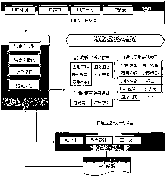
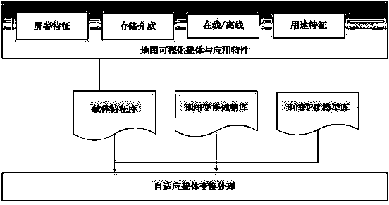
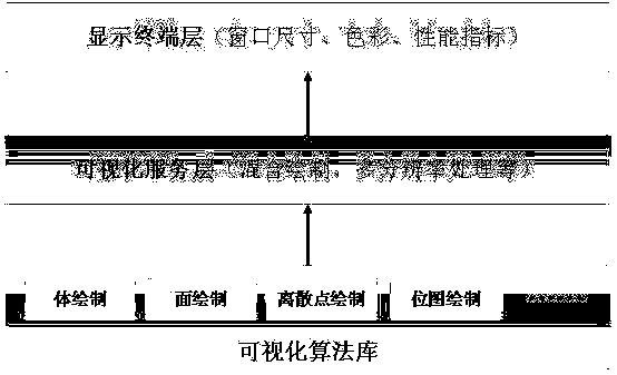
[0011] Such as Figure 1-Figure 3 , the implementation of the present invention needs to solve the following problems: establish user models suitable for different types of users, establish standards for classifying users of geospatial data visualization systems, establish data management mechanisms that can be dynamically constructed and reconfigured according to user needs, consider self- Adaptive graphic and symbolic display and user interface with adaptive features, etc.

[0012] Adaptive geospatial data visualization is based on user scenarios, human-computer interaction behaviors, knowledge reasoning mechanisms, and user feedback evaluation. It has self-organization and self-navigation capabilities based on user models and adaptive hardware, and the ability to predict user behavior. Based on technologies such as webpage application framework design for adaptive terminals and program application framework design for adaptive terminals provided by mainstream mobile termina...


PUM


Abstract

Disclosed is a geographic space information self adaption multiple terminal visualization method. The geographic space information self adaption multiple terminal visualization method is characterized by being based on a three layer architecture system structure, wherein a top layer of the three layer architecture system structure is a spatial data visualization interface layer directly interacted with a user, and used to display spatial data in graphic mode according to a self adaption graphic design scheme, and simultaneously generates various interfaces adaptive to the user according to situations of the user, and presents the various interfaces to the user, a function layer of the three layer architecture system structure is used to achieve the whole self adaption spatial data visualization process, and comprises various core control modules for adaptively visualizing the spatial data, which are respectively a self adaption graphic format model, a self adaption graphic representation model and a self adaption map symbol design model, and a data layer of the three layer architecture system structure is a spatial data library, and comprises user management and geographical space time data analyzing and processing models. Compared with an existing terminal visualization method, the geographic space information self adaption multiple terminal visualization method further considers initiative, spatial attributes and a method adaptive to multiple terminals on the premise of keeping personalized, and really meets exact demands of the multiple terminals based on geographic space information service.

Description

technical field [0001] The invention relates to the intersecting field of computer cloud computing technology, spatial database design and modeling, and visual display of geographic spatial data, in particular to an adaptive multi-terminal visualization method for geographic spatial information. Background technique [0002] As mobile phones, tablets, vehicles, and other embedded devices with network communication functions continue to be widely and deeply used, the traditional adaptive terminal visualization technology only emphasizes the adaptive comprehensive selection and filtering of the application environment-related map thematic content and the automatic level of detail. Adapt to simplified expression, lack of knowledge, behavior and cognitive ability of users, and the symbol library and binding symbol configuration method for specific applications are difficult to actively adapt to a variety of terminals, there are visualization method specifications and design princ...

Claims


Application Information

Patent Timeline
Patent Type & Authority Patents(China)
IPC IPC(8): G06F17/30
CPCG06F16/29G06F16/9537
Inventor 刘福江林伟华徐战亚郭艳黄彩春郭振辉
Owner 武汉图歌信息技术有限责任公司
Why Eureka
Try Eureka