Method for imaging geometric model based on Pluecker straight line

A geometric model and straight line technology, which is applied in the field of imaging geometric models, can solve the problems of easy bending and deformation of the external orientation elements of the image, and difficult realization

Active Publication Date: 2015-04-22
SUZHOU ZHONGKE IMAGE SKY REMOTE SENSING TECH CO LTD
View PDF1 Cites 4 Cited by
  • Summary
  • Abstract
  • Description
  • Claims
  • Application Information

AI Technical Summary

Problems solved by technology

There are two main problems in the traditional imaging geometric model: first, there are few obvious points (intersections and corners) in most remote sensing images, and because of the mutual occlusion of photographic targets and the occlusion of the target itself, it is very difficult to extract

Method used


Image

  • Method for imaging geometric model based on Pluecker straight line
  • Method for imaging geometric model based on Pluecker straight line
  • Method for imaging geometric model based on Pluecker straight line

Examples


example

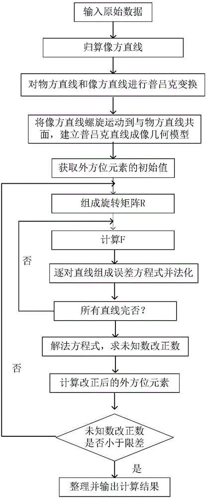
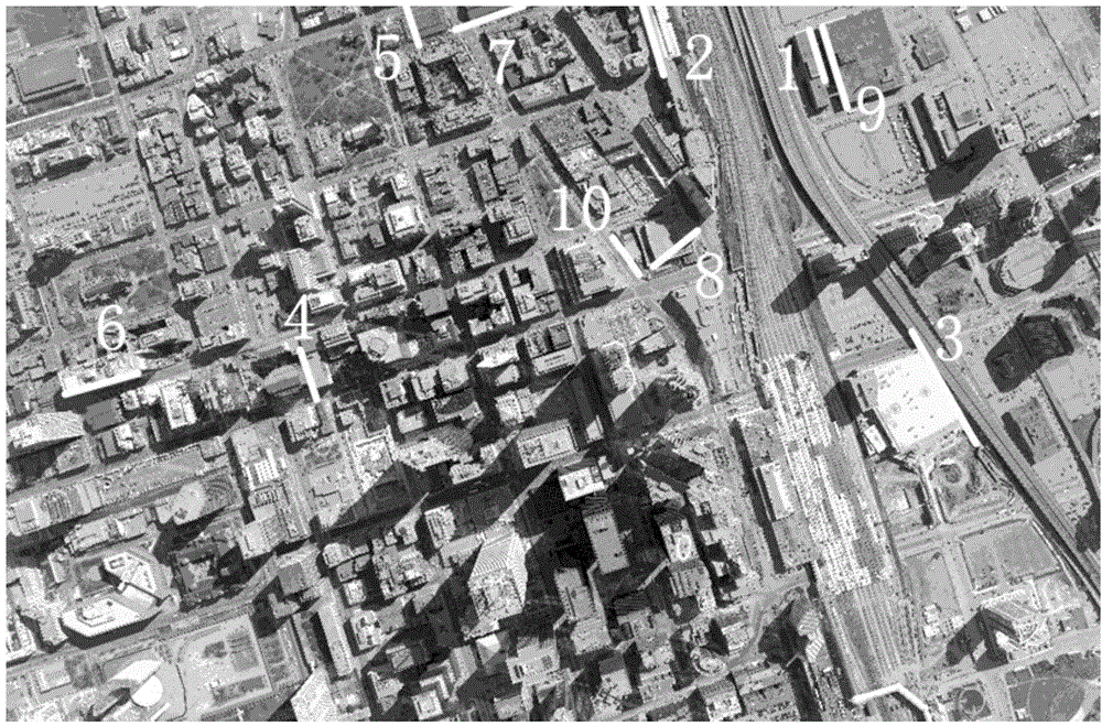
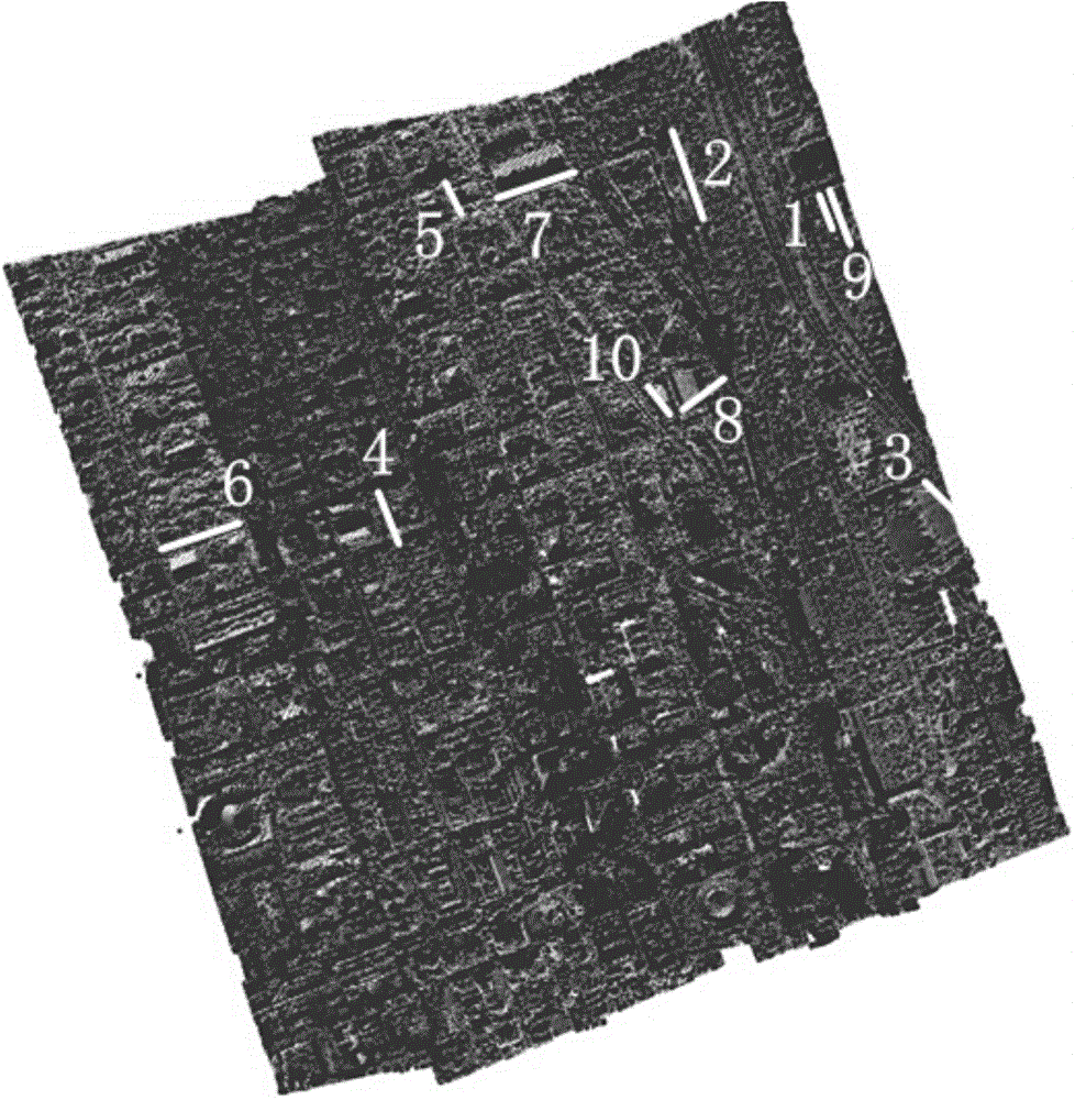
[0124] The aerial image is geometrically positioned according to the airborne LiDAR point cloud of a city. The aerial image is captured by the UltraCam-D (UCD) large-format digital camera of Vexcel. The focal length of the UCD camera is 101.4mm, the CCD pixel size is 9μm, About 1600m, the ground resolution of the image is 15cm, the radiation resolution is 8 bits, and the image size is 7500×11500 pixels, such as figure 2 shown. The LiDAR point cloud is collected by Optech's ALTM ORION M ultra-small airborne lidar, with an average flight altitude of 650m, a speed of 120 nautical miles per hour, and a point cloud density of about 6.0 points / m 2 . like image 3 shown. exist figure 2 and image 3 Among them, 10 image-space straight lines and corresponding object-space straight lines are selected respectively, and they are represented by white, and the image-space straight lines and corresponding object-space straight lines in the figure are marked with numbers. The coordinat...


PUM


Abstract

The invention discloses a method for an imaging geometric model based on a Pluecker straight line, and belongs to the field of surveying and mapping. The method comprises the following steps that a homonymous straight line is extracted from image space and object space; the image space is linearly and spirally moved to be linearly coplanar with the object space, and a coplanar condition equation is obtained; a Pluecker straight line imaging geometric model of a strong geometric condition can be built through the coplanar condition equation; an outer orientation element is calculated through the least square adjustment theory. The spiral movement of a space vector can be visually and clearly represented through the Pluecker straight line, the model is simple, and the geometric meaning is clear. Compared with a traditional method, the imaging geometric model based on the Pluecker straight line is higher in geometric locating precision and more stable in result.

Description

technical field [0001] The invention relates to an imaging geometric model method, which belongs to the field of surveying and mapping science and technology. Background technique [0002] The core problem of photogrammetry is to establish the imaging geometric model, that is, starting from the relationship of various elements in the ground object space, determining the mapping relationship of various spatial elements from the three-dimensional object space to the two-dimensional image space, and restoring the three-dimensional space from the two-dimensional image Correspondence between elements. There are two main problems in the traditional imaging geometric model: first, there are few obvious points (intersections and corners) in most remote sensing images, and because of the mutual occlusion of photographic targets and the occlusion of the target itself, it is very difficult to extract sufficient and accurate feature points. Difficult to realize; secondly, when point ph...

Claims


Application Information

Patent Timeline
IPC IPC(8): G06T7/00
CPCG06T7/13G06T2207/10032
Inventor 盛庆红邵飒王青陈姝文费利佳
Owner SUZHOU ZHONGKE IMAGE SKY REMOTE SENSING TECH CO LTD
Why Eureka
Try Eureka