Transmitting and measuring method of sea-crossing height

A measurement method and elevation measurement technology, which is applied in height/horizontal measurement, measurement devices, surveying and navigation, etc., to reduce adverse effects, improve accuracy and speed, and solve the effect of high-precision cross-sea elevation transfer measurement

Active Publication Date: 2015-04-29
CHINA MAJOR BRIDGE ENERGINEERING
View PDF3 Cites 10 Cited by
  • Summary
  • Abstract
  • Description
  • Claims
  • Application Information

AI Technical Summary

Problems solved by technology

Under such conditions of station shaking, the cross-river leveling method (including technical

Method used


Image

  • Transmitting and measuring method of sea-crossing height
  • Transmitting and measuring method of sea-crossing height
  • Transmitting and measuring method of sea-crossing height

Examples


Embodiment 1

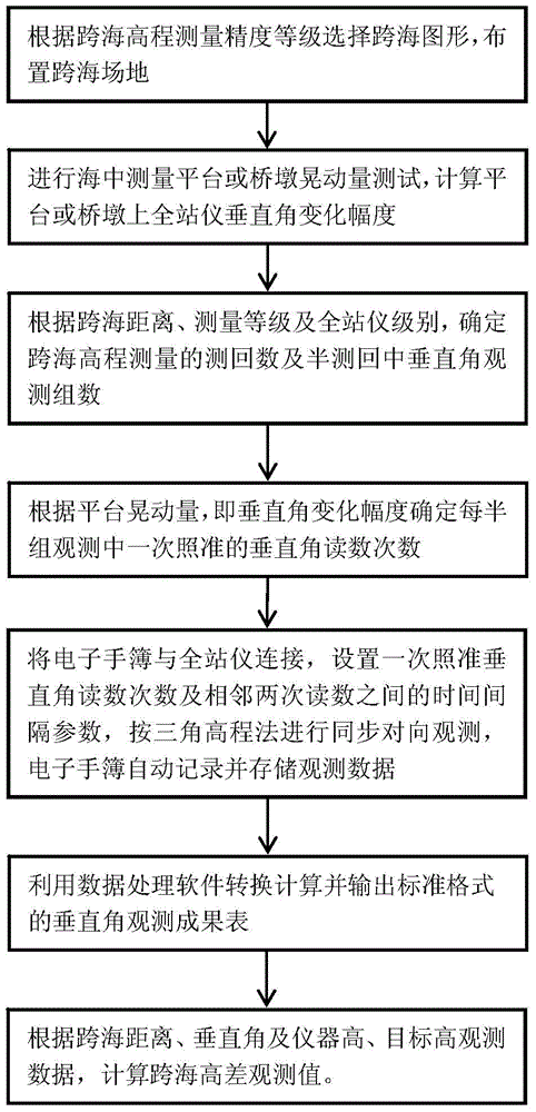
[0021] refer to figure 1 , the specific steps of the cross-sea elevation measurement process are as follows:

[0022] 1) Select cross-sea graphics according to the accuracy level of cross-sea elevation measurement, and arrange cross-sea sites;

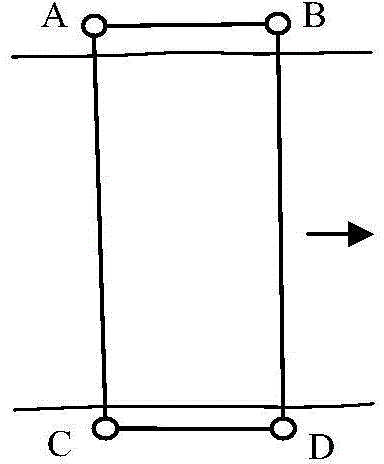
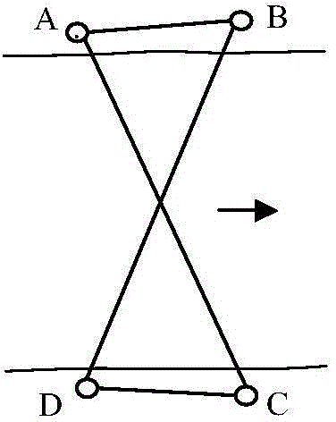
[0023] The two sea-crossing stations are located on the survey platform in the sea, which is convenient for frequently changing the position of the instrument for multiple rounds of observation. Figure 2a ] or an isosceles trapezoid [see Figure 2b ] method to arrange the cross-sea site, using two total stations for synchronous observation; third and fourth-class cross-sea elevation measurement, according to the parallelogram [see Figure 2a ] or an isosceles trapezoid [see Figure 2b ] way to arrange the cross-sea site, using two total stations for synchronous opposite observation; or according to the zigzag [see Figure 2c ] Set up a cross-sea site and use 1 instrument for observation.

[0024] The four sea-crossing points A, B...

Embodiment 2

[0083] Embodiment 2, with embodiment 1, difference is,

[0084] 1) Select cross-sea graphics according to the accuracy level of cross-sea elevation measurement, and arrange cross-sea sites;

[0085] One end of the station is located on the survey platform in the sea, which is convenient for changing the position of the instrument for multi-round observation, and the other end is located on the top of the pier in the sea with a narrow space, which is not convenient for frequently changing the position of the instrument for multi-round observation. according to Figure 2a parallelogram or Figure 2b The cross-sea site is arranged in an isosceles trapezoidal manner. Place the instrument at points A and D, and place the measurement target at points B and C. The cross-sea line-of-sight length (AC, BD) is about 2.1km, measured according to the national second-class cross-sea elevation measurement accuracy.

[0086] The length of each side and the height difference between sea-cr...


PUM


Abstract

The invention relates to a transmitting and measuring method for a sea-crossing height. The method comprises the following steps: according to the measurement accuracy class of the sea-crossing height, choosing a sea-crossing graph, and arranging a sea-crossing site; measuring the waggle quantity of an offshore platform so as to obtain a change range of a vertical angle of a total-station instrument of the platform; according to the sea-crossing distance, the measurement class and the level of the instrument, determining the survey time number of the sea-crossing height measurement and an observing and surveying group number of the vertical angle during semiobservation; according to the wobble quantity of the platform, determining the number of times of reading the vertical angle collimated once; connecting an electronic data recorder with the total-station instrument, setting parameters of the number of the times of reading the vertical angle collimated once, a time interval between the twice adjacent reading and the like, performing synchronous opposite direction observation by a triangulated height method, and automatically recording and storing observation data by the electronic data recorder; calculating and outputting an observing and surveying outcome table of the vertical angle in a standard format by using interior work software; according to observation data of the sea-crossing distance, the altitude of the vertical angle, the altitude of the instrument, the altitude of a target and the like, calculating a sea-crossing altitude difference observing and surveying value. The transmitting and measuring method disclosed by the invention is particularly suitable for transmitting and measuring the sea-crossing height of the total-station instrument of a measuring station under the condition of wobble.

Description

technical field [0001] The invention relates to the technical field of cross-sea elevation transfer, in particular to a method for measuring the cross-sea elevation of a total station under the condition of station shaking, which is applicable to the cross-sea elevation transfer measurement of a survey platform in the sea or a bridge pier in the sea under various sea conditions . Background technique [0002] The cross-river leveling method stipulated in the "National First and Second Class Leveling Standards" (GBT12897-2006) is only applicable to the cross-sea elevation measurement where the stations at both ends of the cross-sea route are on stable structures. The vertical angle change value of the total station placed on the stable ground or other stable structures is less than 1 second, but in the cross-sea elevation transfer measurement, one or both ends of the cross-sea route are located on unstable structures such as measurement platforms or bridge piers in the sea O...

Claims


Application Information

Patent Timeline
IPC IPC(8): G01C5/00
CPCG01C5/00
Inventor 吴迪军熊伟曹诗荣李剑坤郑强
Owner CHINA MAJOR BRIDGE ENERGINEERING
Why Eureka
Try Eureka