Airplane onboard GPS and inertial navigation system combined positioning method

An inertial navigation system and combined positioning technology, which is applied in the field of aircraft airborne GPS and inertial navigation system combined positioning, can solve problems such as the failure to combine GPS and INS technology, and achieve the effect of improving positioning accuracy and reliability

Active Publication Date: 2015-04-29
CETC AVIONICS
View PDF3 Cites 16 Cited by
  • Summary
  • Abstract
  • Description
  • Claims
  • Application Information

AI Technical Summary

Problems solved by technology

[0003] At present, the development of civil aircraft in my country is still in its infancy, and the development of combined positioning of airborne GPS and airborne inertial navigation is still blank. The related design of combined positioning mainly adopts hard switching, which fails to effectively combine GPS and INS technology.

Method used


Image

  • Airplane onboard GPS and inertial navigation system combined positioning method
  • Airplane onboard GPS and inertial navigation system combined positioning method
  • Airplane onboard GPS and inertial navigation system combined positioning method

Examples


Embodiment Construction

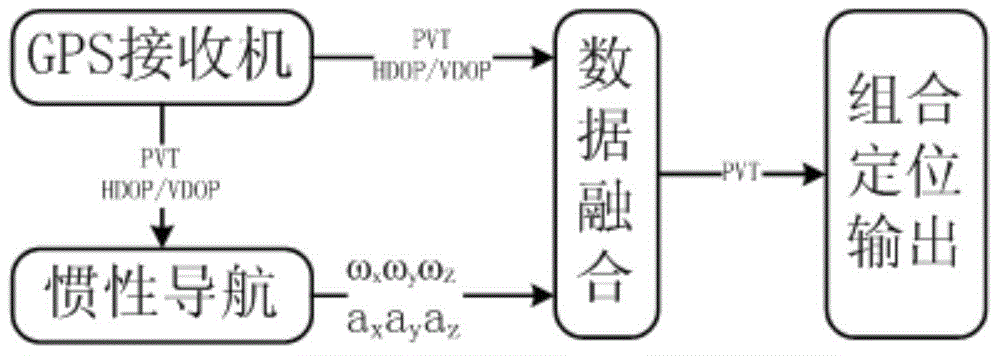
[0018] figure 1 Among them, is the principle diagram of GPS and inertial navigation combined positioning function of the present invention. As shown in the figure, PVT represents the position, velocity and time information output by the GPS receiver; the inertial navigation (referred to as inertial navigation or INS) output ωxωyωZ represents the three-axis angular velocity output by the inertial navigation system gyroscope, and the inertial navigation output axayaz represents the acceleration of the inertial navigation system That is, output three-axis acceleration, data fusion mainly includes GPS and inertial navigation weight design, and KALMAN data fusion.

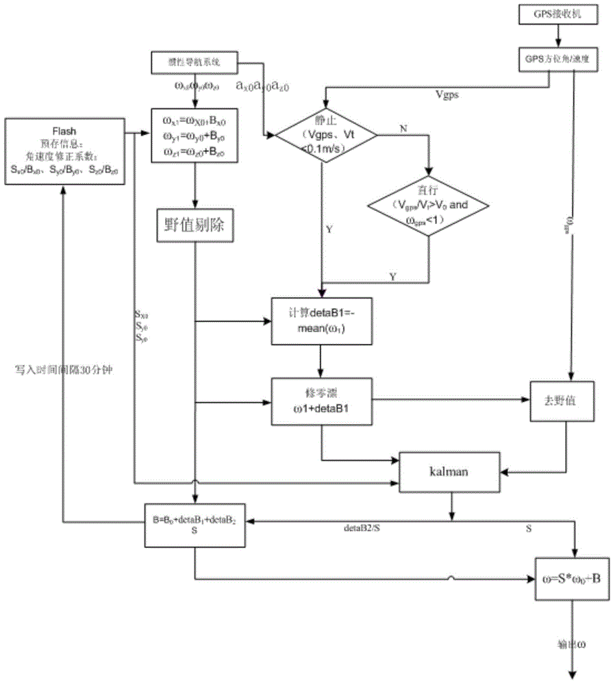
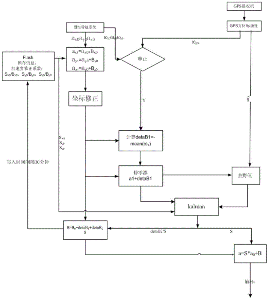
[0019] Figure 2 to Figure 4 Shown, relate to a kind of aircraft airborne GPS and inertial navigation system combined positioning method of the present invention, it comprises following construction steps:

[0020] a. Construct the inertial navigation angular velocity error model, and correct the inertial navigation a...


PUM


Abstract

The invention discloses an airplane onboard GPS and inertial navigation system combined positioning method. The method includes the following constructing steps that firstly, an inertial navigation angular speed error model is constructed, and an inertial navigation angular speed error is corrected through a GPS; a gyroscope output angular speed error model is constructed, an inertial navigation angular speed zero drift error is corrected through static or horizontal linear movement, an inertial navigation angular speed linear error is corrected through linear fitting of a Kalman filter, and finally the inertial navigation angular speed error is corrected; secondly, an accelerometer output acceleration error model is constructed, and an inertial navigation acceleration speed error is corrected by correcting an inertial navigation acceleration zero drift error and correcting an inertial navigation acceleration linear error through the Kalman filter. According to the airplane anboard GPS and inertial navigation system combined positioning method, due to the fact that the gyroscope output angular speed error model and the accelerometer output acceleration error model are constructed and the INS three-axis angular speed and the three-axis acceleration are corrected dynamically through the GPS, the GPS and the INS technology can be effectively combined.

Description

technical field [0001] The invention relates to a combined positioning method of an aircraft airborne GPS and an inertial navigation system. Background technique [0002] The current airborne navigation systems mainly include GPS navigation system and inertial navigation system. The GPS navigation system is the core system of the aircraft's radio navigation system, providing position, speed and time information for the entire avionics system of the aircraft; the inertial navigation system provides the aircraft with the current triaxial acceleration and triaxial angular velocity information. [0003] At present, the development of civil aircraft in my country is still in its infancy, and the development of combined positioning of airborne GPS and airborne inertial navigation is still blank. The related design of combined positioning mainly adopts hard switching, which fails to effectively combine GPS and INS technology. Contents of the invention [0004] The object of the ...

Claims


Application Information

Patent Timeline
Patent Type & Authority Applications(China)
IPC IPC(8): G01S19/47
CPCG01S19/47
Inventor 冯众保候静姚宪国
Owner CETC AVIONICS
Why Eureka
Try Eureka