

Indoor navigation method based on combination of region location, inertial navigation and map path
An inertial navigation and regional positioning technology, applied in the field of navigation technology, can solve the problems of high maintenance cost and insufficient positioning accuracy, and achieve the effects of reduced deployment and maintenance costs, improved accuracy, and high positioning and navigation accuracy and accuracy
- Summary
- Abstract
- Description
- Claims
- Application Information
AI Technical Summary
Problems solved by technology
Method used
Image

Examples
Embodiment Construction
[0014] The present invention will be further described in detail below in conjunction with the accompanying drawings and embodiments.
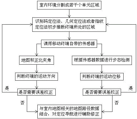
[0015] Such as figure 1 As shown, an indoor navigation method based on regional positioning combined with inertial navigation and map path, the specific steps are as follows.
[0016] S1, area identification and positioning.
[0017] The indoor environment in which the mobile terminal is located and needs positioning and navigation is divided into several unit areas, for example, a grid-like square of 3 meters by 3 meters is used as an area, or an area with an irregular shape. Then, based on one or more signal sources of WiFi, Bluetooth, geomagnetism, light, and sound waves, the area where the terminal is located is preliminarily inferred by using the identification code positioning method, geometric positioning method or fingerprint positioning method.
[0018] According to the existing technology, the regional judgment has a high accuracy ...
PUM
 Abstract
Description
Claims
Application Information