Reservoir water storage amount remote sensing and ground concurrent monitoring method

A technology of water storage and reservoir water level, which is applied in the direction of volume measurement instruments/methods, open-air water source survey, and measurement capacity, can solve the problems of reservoir water storage estimation errors and reservoir characteristic curves are difficult to update regularly, and achieve the goal of improving accuracy Effect

Inactive Publication Date: 2015-05-13
CHINA INST OF WATER RESOURCES & HYDROPOWER RES
View PDF2 Cites 25 Cited by
  • Summary
  • Abstract
  • Description
  • Claims
  • Application Information

AI Technical Summary

Problems solved by technology

[0003] The main purpose of the present invention is to provide a method for remote sensing and ground collaborative monitoring of reservoir water storage, which overcomes the error probl

Method used


Image

  • Reservoir water storage amount remote sensing and ground concurrent monitoring method
  • Reservoir water storage amount remote sensing and ground concurrent monitoring method
  • Reservoir water storage amount remote sensing and ground concurrent monitoring method

Examples


Embodiment Construction

[0038] In order to make the technical problems, technical solutions and advantages to be solved by the present invention clearer, the following will describe in detail with reference to the drawings and specific embodiments.

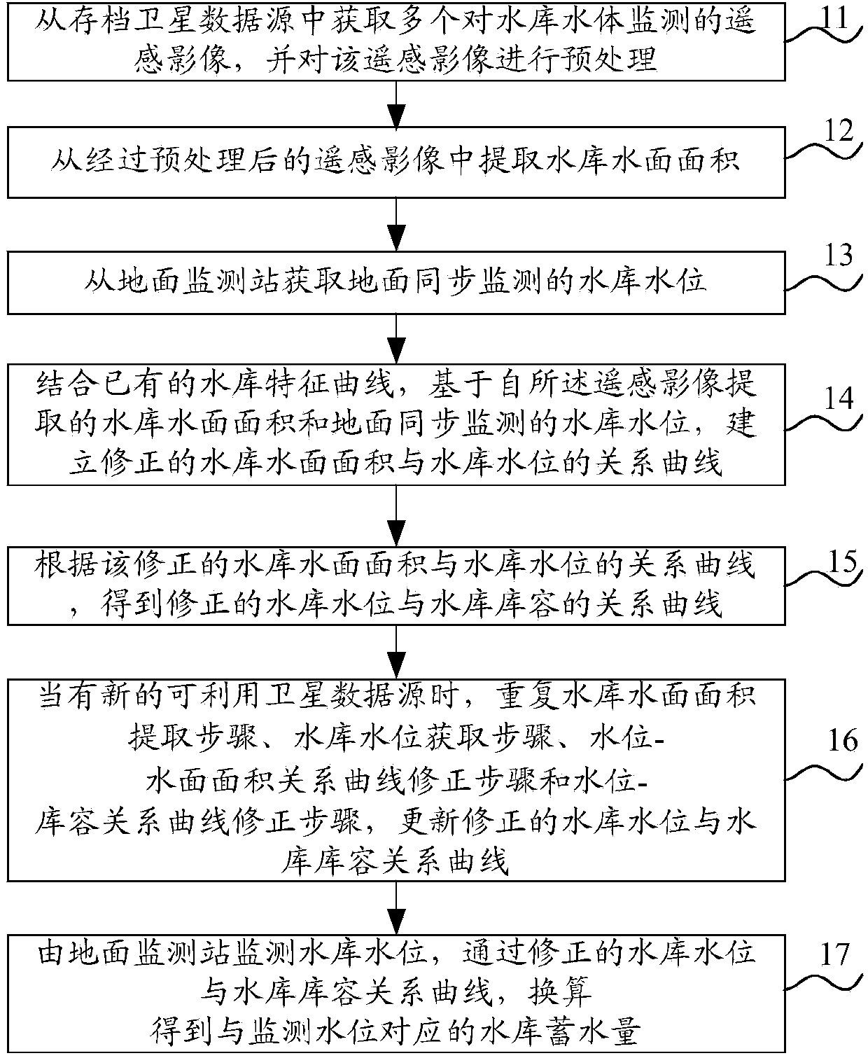
[0039] Such as figure 1 As shown, the reservoir water storage monitoring method described in the embodiment of the present invention comprises:

[0040] Preprocessing step 11: Obtain multiple remote sensing images of reservoir water monitoring from archived satellite data sources, and preprocess the remote sensing images;

[0041] Reservoir water surface area extraction step 12: extracting the reservoir water surface area from the preprocessed remote sensing images;

[0042] Reservoir water level acquisition step 13: Obtain the ground synchronously monitored reservoir water level from the ground monitoring station;

[0043] Water level-water surface area relationship curve correction step 14: combined with the existing reservoir characteristic curve, b...


PUM


Abstract

A reservoir water storage amount remote sensing and ground concurrent monitoring method is as follows: multi-period reservoir water monitoring remote sensing images can be acquired from archived satellite data sources, and the remote sensing images can be pretreated; reservoir water surface area can be extracted from the pretreated remote sensing images; ground synchronous monitoring reservoir water level can be acquired from a ground monitoring station; a correctional relation curve of the reservoir water level and the reservoir water surface area can be established; according to the correctional relation curve of the reservoir water level and the reservoir water surface area, a correctional relation curve of the reservoir water level and reservoir storage capacity can be acquired; when a new satellite data source is available, the above steps are repeated, the relation curve of the reservoir water level and the reservoir storage capacity can be updated and corrected; the reservoir water level can be monitored by the ground monitoring station, and the reservoir water storage capacity corresponding to the monitoring water level can be obtained by conversion according to the corrected relation curve of the reservoir water level and the reservoir storage capacity. The reservoir water storage amount remote sensing and ground concurrent monitoring method can effectively eliminate the influence of the characteristic curve changes of the reservoir after a long time running on reservoir water storage amount, and improves the accuracy of the reservoir water storage condition monitoring.

Description

technical field [0001] The invention relates to the field of monitoring and evaluation of reservoir water storage conditions, in particular to a remote sensing and ground collaborative monitoring method for reservoir water storage. Background technique [0002] There are 98,002 small-scale or above reservoirs in my country, and 2,865 lakes with a water area larger than 1 square kilometer all year round. Most of these small and medium-sized water bodies in these surface water sources lack direct and objective monitoring information. come difficult. On the other hand, a large number of large and medium-sized reservoirs have been built for many years. Due to the change of bank slope shape caused by sedimentation and erosion in the reservoir area, the characteristic curve of the reservoir has changed. However, the characteristic curve of the reservoir is remeasured according to the traditional ground measurement method. The volume is huge, and it is difficult to carry out regula...

Claims


Application Information

Patent Timeline
IPC IPC(8): G01C13/00G01F22/00
CPCG01C13/00G01C13/008Y02A90/30
Inventor 赵红莉蒋云钟朱鹤马淑娇张双虎冶运涛陈德清成建国
Owner CHINA INST OF WATER RESOURCES & HYDROPOWER RES
Why Eureka
Try Eureka