Reconstruction method for terrain of shallow-sea large-sized complicated sand wave area

A shallow sea, large-scale technology, applied in the direction of surveying devices, instruments, surveying and navigation, etc., can solve the problems of inability to meet high-precision terrain reconstruction, complex spatial layout, etc., and achieve the effect of great practical value

Active Publication Date: 2015-05-13
SECOND INST OF OCEANOGRAPHY MNR
View PDF7 Cites 8 Cited by
  • Summary
  • Abstract
  • Description
  • Claims
  • Application Information

AI Technical Summary

Problems solved by technology

However, the inventive method can only achieve good results in the terrain reconstruction of sand wave areas in small areas with simple sand wave shapes and regular distribution. The layout is complex and still cannot meet the requirements of high-precision terrain reconstruction

Method used


Image

  • Reconstruction method for terrain of shallow-sea large-sized complicated sand wave area
  • Reconstruction method for terrain of shallow-sea large-sized complicated sand wave area
  • Reconstruction method for terrain of shallow-sea large-sized complicated sand wave area

Examples


Embodiment 1

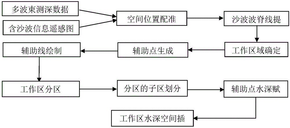
[0041]Experiments are carried out according to the shallow sea large-scale complex sand wave area terrain reconstruction method of the present invention, such as figure 1 As shown, it specifically includes the following steps:

[0042] (1) Adopt the method of the first step in the invention patent method (ZL201310043013.2) to obtain the remote sensing image containing sand wave information in the coverage area of ​​the multi-beam bathymetry data, and use the geometric correction method to perform positioning and registration of the remote sensing image to realize the integration with the multi-beam Basic registration of bathymetric data space:

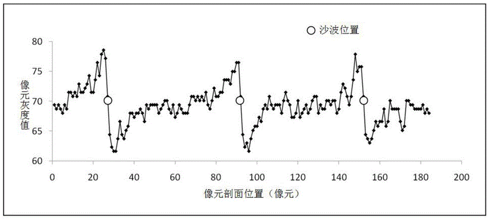
[0043] Select remote sensing images with higher resolution in the study area to check the clarity and integrity of the sand wave texture information in the images. The spatial registration between the remote sensing image and the multibeam bathymetric data is carried out before the sand wave ridge information is extracted. Image regi...


PUM


Abstract

The invention discloses a reconstruction method for terrain of a shallow-sea large-sized complicated sand wave area. According to the reconstruction method, the terrain reconstruction is carried out on multi-beam depth sounding data of the shallow-sea large-sized complicated sand wave area acquired in an interval measuring line way by utilizing characteristic information (sand wave ripples and wave ridges) in a remote sensing image and the distribution rule of the sand wave terrain, so that complete sand wave terrain information can be acquired. Aiming at the surveying and mapping requirement of the shallow-sea sand wave area which is widely distributed, the sand wave ripples and the sand wave ridges in the remote sensing image are used as reference control information to be introduced into the multi-beam depth sounding data terrain reconstruction, the high-precision terrain reconstruction of the multi-beam depth sounding data acquired in the interval measuring line way in the shallow-sea large-sized complicated sand wave area can be realized by virtue of partition combination and overlap continuous assignment treatment of the large-sized complicated sand wave area can be realized, and the reconstruction method is an innovation on the aspect of cross application of a remote sensing information technology and a multi-beam depth sounding technology and is relatively high in practical value.

Description

technical field [0001] The invention belongs to the field of remote sensing technology application and seabed topography surveying and mapping, and specifically relates to a method that can use the sand wave and sand ridge characteristic information contained in the remote sensing image, as desired, to analyze large-scale complex sand wave areas in shallow seas obtained by means of interval survey lines. A method for efficient terrain reconstruction from multibeam bathymetric data. Background technique [0002] Seabed topographic mapping is the first step in exploring and studying the ocean, the first condition for developing and protecting the ocean, and an urgent need for oceanographic research today. Before the invention of the echo sounder, the water depth was mainly measured by the sounding rod and the sounding hammer, and the measurement accuracy was poor. After the echo sounder appeared in the 1920s, the drawing of sea charts in the modern sense was realized. Howeve...

Claims


Application Information

Patent Timeline
Patent Type & Authority Applications(China)
IPC IPC(8): G01C13/00
CPCG01C13/00Y02A90/30
Inventor 张华国傅斌何谢锴厉冬玲史爱琴楼琇林
Owner SECOND INST OF OCEANOGRAPHY MNR
Why Eureka
Try Eureka