Existing railway measuring method based on LIDAR (Light Detection and Ranging) track point cloud data

A technology based on point cloud data and existing railways. It is applied in the directions of measuring devices, measuring distances, surveying and navigation, etc. It can solve the problems of many operators on the road, poor measurement flexibility, and limited measurement length.

Active Publication Date: 2015-05-20
CHINA RAILWAY FIRST SURVEY & DESIGN INST GRP
View PDF6 Cites 23 Cited by
  • Summary
  • Abstract
  • Description
  • Claims
  • Application Information

AI Technical Summary

Problems solved by technology

[0005] The purpose of the present invention is to provide an existing railway measurement method based on LIDAR track point cloud data, which overcomes the problems of poor measurement flexibility of existing existing lines, limited measurement length, and many times of operators on the track

Method used


Image

  • Existing railway measuring method based on LIDAR (Light Detection and Ranging) track point cloud data
  • Existing railway measuring method based on LIDAR (Light Detection and Ranging) track point cloud data
  • Existing railway measuring method based on LIDAR (Light Detection and Ranging) track point cloud data

Examples


Embodiment Construction

[0056] The present invention will be described in detail below in combination with specific embodiments.

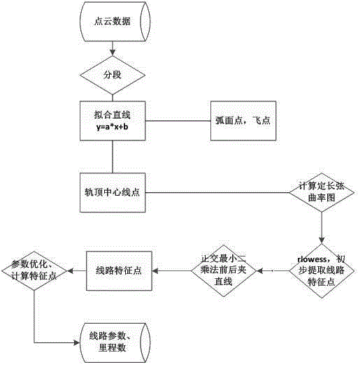
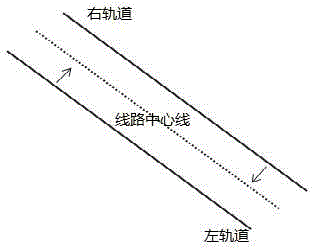
[0057] The existing railway measurement method based on LIDAR track point cloud data involved in the present invention is an existing railway remeasurement method based on track point cloud data. The recorded continuous three-dimensional coordinate data includes left track and right track data, and the measurement method specifically includes the following steps:

[0058] Step 1: Extract the center line of the two rails according to a certain length of the left and right rails.

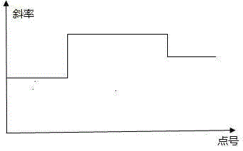
[0059] According to a certain length, the left and right rails extract n data sequentially from the original point set, and extract the centerlines of the two rails according to the least square method;

[0060] Q ≡ Q ( a , b ) = Σ i ...


PUM


Abstract

The invention relates to an existing railway measuring method based on LIDAR (Light Detection and Ranging) track point cloud data. The existing railway line measurement has the defects of poor flexibility and limited measuring length. The method comprises the following steps: recording continuous three-dimensional coordinate data in a track running process by using a vehicle-mounted LIDAR measurement instrument for serving as track point cloud data; extracting a center line between two tracks, translating o obtain a route center line, and calculating the fixed-length chord slope of the route center line: evaluating the slope by taking new data serving as a point set as a difference, generating a fixed-length chord slope sequence, and filtering; picking segmentation points on the basis of the smooth fixed-length chord slope, and decomposing a continuous route into curve units; evaluating the intersection points among the curves according to front and back intermediate straight lines of each unit, fitting the radius and circle center of a circular curve part of the route, and resolving a corresponding route parameter and mileage. A basic unit set of route curve elements is constructed according to the LIDAR track point cloud data, so that the aims of route reconstruction and retesting are fulfilled, high flexibility, high measuring efficiency and a simple process are realized, and measured data is accurate and reliable.

Description

technical field [0001] The invention belongs to the technical field of railway measurement, and in particular relates to an existing railway measurement method based on LIDAR track point cloud data. Background technique [0002] Railway lines (including rails and roadbeds) are the most important infrastructure for railway operations. The rails are directly subjected to huge pressure from the wheelsets of vehicles, causing various deformations and affecting the high-speed and smooth operation of trains. The deformation of the track is described by roughness. Track irregularities are deviations of the track's geometry, size and spatial relative position from its normal state. [0003] The premise of evaluating the smoothness of the line is to obtain the spatial position status of the line, which requires retesting of the existing railway lines. The traditional planar curve measurement method based on the involute principle, in actual operation, has a large error in the fluct...

Claims


Application Information

Patent Timeline
Patent Type & Authority Applications(China)
IPC IPC(8): G01B21/00G01C22/00
CPCG01B21/00
Inventor 李飞任晓春罗文彬
Owner CHINA RAILWAY FIRST SURVEY & DESIGN INST GRP
Why Eureka
Try Eureka