Unmanned aerial vehicle landing position search system based on image treatment

A search system and image processing technology, applied in the field of image processing, can solve the problems of lack of accurate and suitable landform feature data, difficulty in landing, and inability to accurately locate the landing point for drones to land, etc.

Active Publication Date: 2015-05-27
湛江市树淼科技有限公司
View PDF4 Cites 27 Cited by
  • Summary
  • Abstract
  • Description
  • Claims
  • Application Information

AI Technical Summary

Problems solved by technology

[0005] Although UAVs are widely used, compared with the take-off stage, their landing is a difficult problem, especially in the search for landing points with suitable landforms. There has been a l

Method used


Image

  • Unmanned aerial vehicle landing position search system based on image treatment

Examples


Embodiment Construction

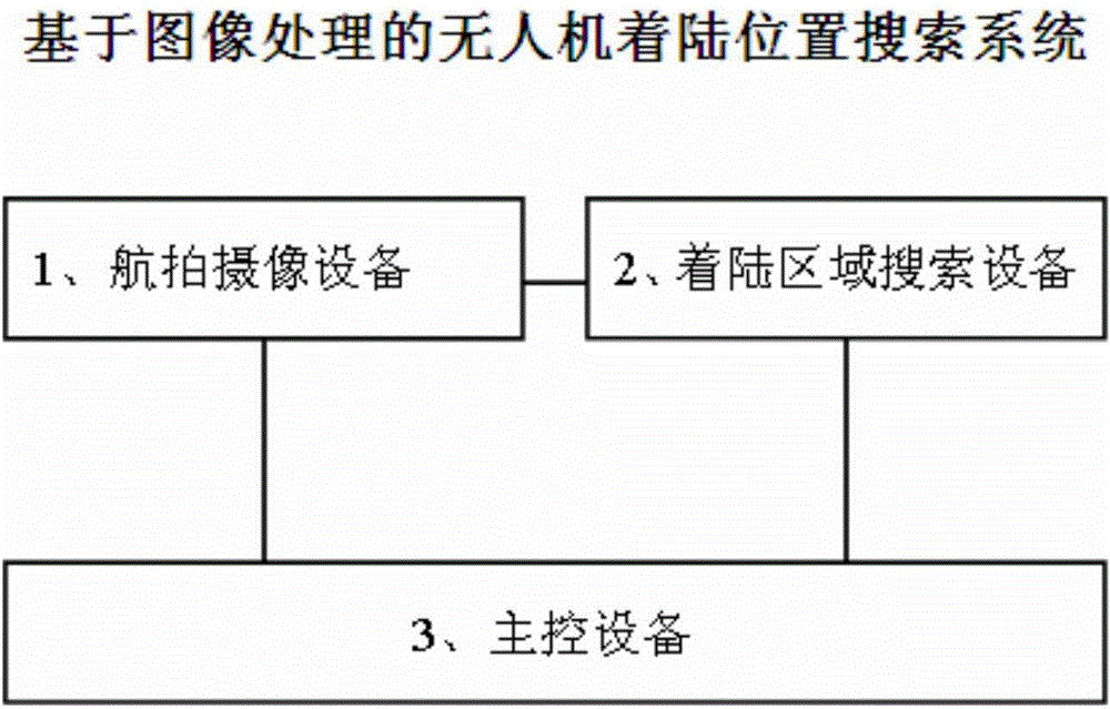
[0014] The implementation of the image processing-based UAV landing position search system of the present invention will be described in detail below with reference to the accompanying drawings.

[0015] At present, the application fields of UAVs are becoming more and more extensive, so people's requirements for the intelligence of UAVs are also getting higher and higher.

[0016] During the take-off stage of the UAV, since the take-off point is fixed, all the parameters on the UAV are the initial parameters after multiple adjustments at the beginning of take-off, so the UAV at this time is extremely controllable , the take-off operation can be completed according to the predetermined level. Relatively speaking, the UAV is in the landing stage, that is, the recovery stage of the UAV. Since the landing point is determined according to the specific terrain, and the various parameters of the UAV have been passed During long-term flight, errors may occur. At this time, the control...


PUM


Abstract

The invention relates to an unmanned aerial vehicle landing position search system based on image treatment. The unmanned aerial vehicle landing position search system is arranged on an unmanned aerial vehicle, and comprises air photograph equipment, landing area search equipment and master control equipment, wherein the air photograph equipment is used for collecting images below an unmanned aerial vehicle body to obtain images below the machine body; the landing area search equipment is connected with the air photograph equipment and is used for carrying out image treatment on the images below the machine body and searching the landing area corresponding to the geomorphic type suitable for landing from the images below the machine body; and the master control equipment is connected with the landing area search equipment, and is used for transmitting landing position information corresponding to the landing area to unmanned aerial vehicle drive equipment to drive the unmanned aerial vehicle to land on the landing position. The unmanned aerial vehicle landing position search system is capable of helping the unmanned aerial vehicle search out the proper landing position to land, so that manual intervention is reduced; and the intelligence level of the unmanned aerial vehicle is improved.

Description

technical field [0001] The invention relates to the field of image processing, in particular to an image processing-based UAV landing position search system. Background technique [0002] Unmanned aerial vehicle (unmanned aerial vehicle or drone) is the abbreviation of unmanned aircraft, and the English abbreviation is "UAV". It is an unmanned aircraft controlled by radio remote control equipment and its own program control device. From a technical point of view, it can be divided into: unmanned helicopter, unmanned fixed-wing aircraft, unmanned multi-rotor aircraft, unmanned airship, unmanned parawing aircraft, etc. [0003] A drone is an unmanned aerial vehicle operated by a radio remote control device or its own program control device. It first appeared in the 1920s and was used as a target drone for training. is a term used by many countries to describe the latest generation of unmanned aircraft. Literally, the term can describe cruise missiles that have evolved from ...

Claims


Application Information

Patent Timeline
IPC IPC(8): G05D1/12
Inventor 不公告发明人
Owner 湛江市树淼科技有限公司
Why Eureka
Try Eureka