Device for measuring sea surface height based on time-delay modification

A height measurement device and time delay correction technology, applied in radio wave measurement systems, instruments, etc., can solve problems such as lack of measurement errors, and achieve the effects of strengthening monitoring capabilities, reducing errors, and reducing computational complexity

Active Publication Date: 2015-06-03
山东航向电子科技有限公司
View PDF3 Cites 11 Cited by
  • Summary
  • Abstract
  • Description
  • Claims
  • Application Information

AI Technical Summary

Problems solved by technology

[0004] In the measurement of sea surface height, there is a lack of a simple and direct solution to the measurement error caused by sea surface roughness

Method used


Image

  • Device for measuring sea surface height based on time-delay modification
  • Device for measuring sea surface height based on time-delay modification
  • Device for measuring sea surface height based on time-delay modification

Examples


Embodiment Construction

[0029] The present invention will be further described in detail below in conjunction with the accompanying drawings.

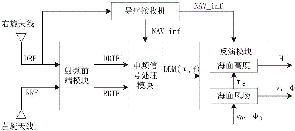
[0030] Such as figure 1 It is the overall structure diagram of the device.

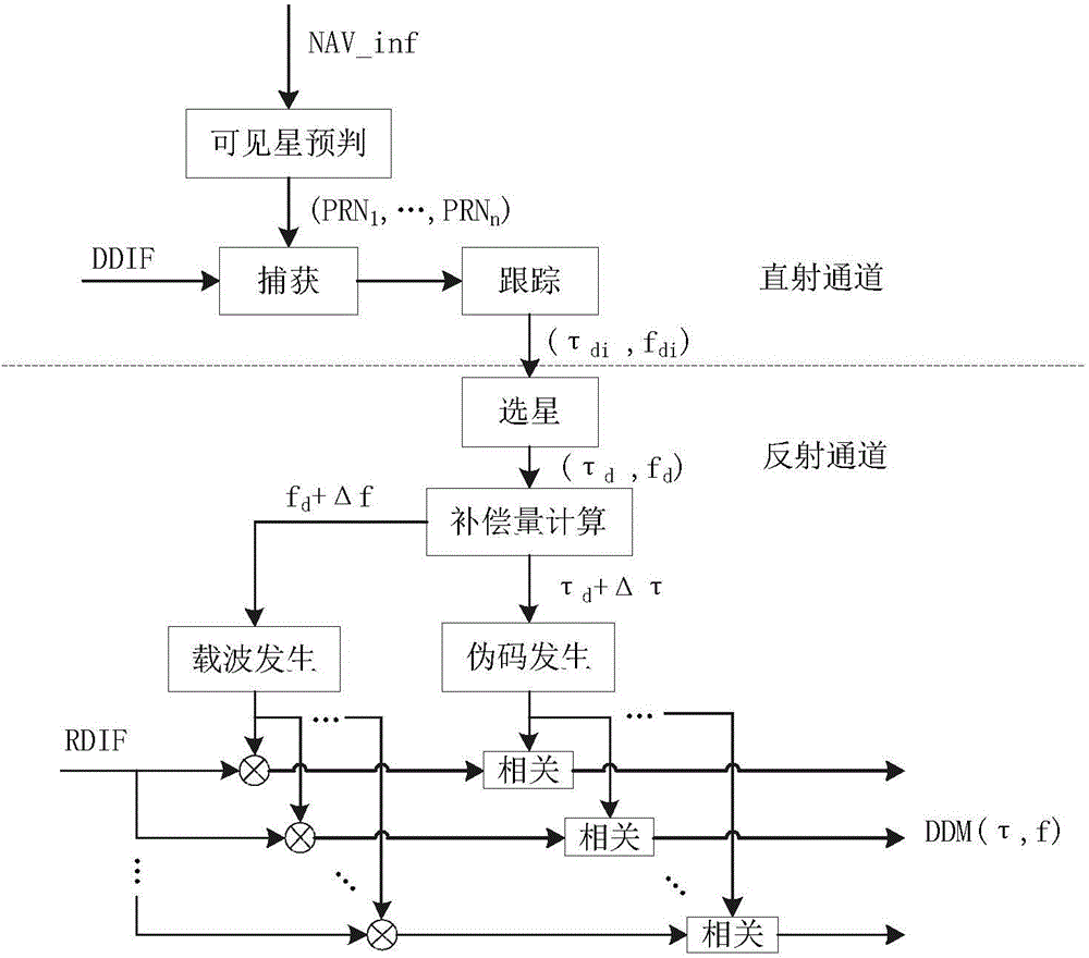
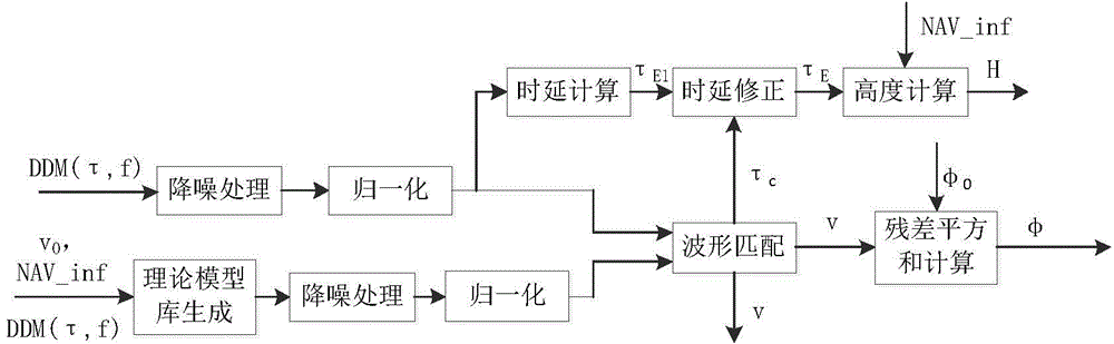
[0031] The device of the invention is composed of a navigation receiver, a commercial GNSS right-handed antenna, a multi-element array type left-handed antenna, a radio frequency front-end module, an intermediate frequency signal processing module and an inversion module. The position connection relationship between them is: the navigation receiver is connected with the right-handed antenna, the intermediate frequency signal processing module and the inversion module respectively, the right-handed antenna and the left-handed antenna are independent of each other, and together with the RF front-end module, the intermediate frequency signal processing module and the The inversion modules are connected sequentially. The signal direction between them is: the direct RF voltage signal DR...


PUM


Abstract

The invention discloses a device for measuring sea surface height based on time-delay modification. The device comprises a navigation receiver, a right-hand antenna, a left-hand antenna, a radio-frequency front end module, an intermediate frequency signal processing module and an inversion module. The navigation receiver is connected with the right-hand antenna, the intermediate frequency signal processing module and the inversion module, and the right-hand antenna and the left-hand antenna are independent with each other and connected with the radio-frequency front end module, the intermediate frequency signal processing module and the inversion module sequentially; a direct radio-frequency voltage signal transmitted from the right-hand antenna and a reflective radio-frequency voltage signal transmitted from the left-hand antenna are adopted as the input of the radio-frequency front end module, a direct digital intermediate frequency signal and the reflective digital intermediate frequency signal transmitted from the radio-frequency front end module are adopted as the input of the intermediate frequency signal processing module, time-delay doppler two-dimensional related power transmitted from the intermediate frequency signal processing module is adopted as the input of the inversion module, the direct radio-frequency voltage signal transmitted from the right-hand antenna is adopted as the input of the navigation receiver, and navigation information transmitted from the navigation receiver is adopted as the input of the intermediate frequency signal processing module and the inversion module.

Description

technical field [0001] The invention relates to a sea surface height measuring device based on time delay correction. Specifically, the time delay error caused by sea surface roughness in the GNSS-R (Global Navigation Satellites System-Reflectmetry) sea surface wind field inversion result is used to correct the time delay error caused by sea surface roughness in the altimetry process. Thereby improving the measurement accuracy. Background technique [0002] As a new remote sensing method, GNSS-R has attracted extensive attention from scholars at home and abroad. At present, GNSS-R is gradually improving in terms of theory, technology and data retrieval. Ocean remote sensing based on GNSS-R is a major part of the GNSS-R remote sensing field, and its main development direction is sea surface wind field and sea surface height. So far, many experiments have been carried out in the world to detect sea surface wind field and sea surface height, and the theory and algorithm of G...

Claims


Application Information

Patent Timeline
Patent Type & Authority Applications(China)
IPC IPC(8): G01S7/41
CPCG01S7/41
Inventor 杨东凯郝清玉沈海鸿王峰
Owner 山东航向电子科技有限公司
Why Eureka
Try Eureka