Map information processing device, and storage medium
An information processing device and map technology, which is applied in the direction of measuring devices, maps/plans/charts, satellite radio beacon positioning systems, etc., can solve the problem of not being able to set the attributes of the parking lot
- Summary
- Abstract
- Description
- Claims
- Application Information
AI Technical Summary
Problems solved by technology
Method used
Image
Examples
no. 1 Embodiment approach
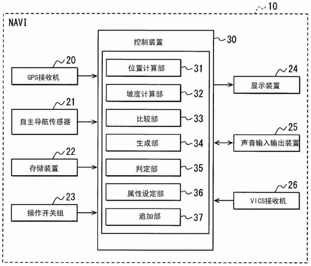
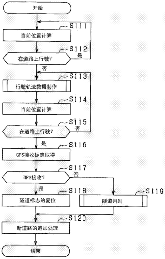
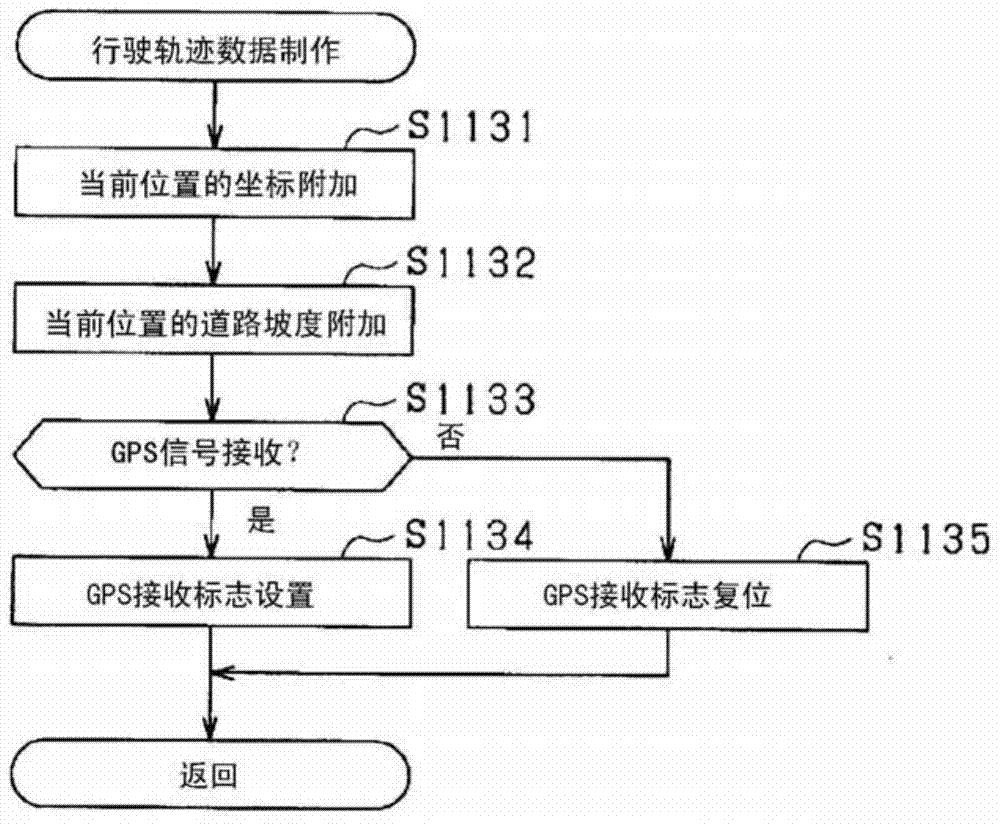
[0040] figure 1 It is a figure which shows the structure of the navigation apparatus 10 when the map information processing apparatus concerning 1st Embodiment of this disclosure was applied to the navigation apparatus (NAVI) 10. The navigation device 10 determines whether or not the new road is a tunnel, and adds new road data to the map data. The navigation device 10 includes a global positioning system (GPS) receiver (GPS REC) 20, an autonomous navigation sensor (SELF-CONT NAVI SENS) 21, a storage device (STORAGE) 22, an operation switch group (SWITCH) 23, and a display device (DISPLAY) 24. Audio input and output device (AUDIO) 25, VICS (registered trademark) receiver (VICS REC) 26, control device (CONTROL) 30.
[0041] The GPS receiver 20 receives GPS signals transmitted from GPS satellites, and detects the absolute position and the absolute orientation of the vehicle. The current position of the vehicle detected by the GPS receiver 20 and the reception strength of the ...
no. 2 Embodiment approach
[0083] About the navigation device 10 which concerns on 2nd Embodiment, the point which differs from the navigation device 10 which concerns on 1st Embodiment is demonstrated. The navigation device 10 according to the second embodiment determines whether or not a new road is an underpassing road, and adds new road data to map data.
[0084] The determination unit 35 of the navigation device 10 according to the second embodiment stores the background information stored in the storage device 22 in the case where the travel trajectory data generated by the generation unit 34 includes data indicating that there is no GPS signal reception. The data is read out, and it is judged whether the driving track of the vehicle overlaps with the railway on the ground. Therefore, the determination unit 35 functions as an overlap determination unit.
[0085] Further, the attribute setting unit 36 sets the underpass road attribute to the traveling trajectory data on the condition that the ve...
no. 3 Embodiment approach
[0102] About the navigation device 10 which concerns on 3rd Embodiment, the point which differs from the navigation device 10 which concerns on 1st Embodiment is demonstrated. The navigation device 10 according to the third embodiment determines whether or not a new road is an underpassing road, and adds new road data to map data.
[0103] The judging unit 35 of the navigation device 10 according to the third embodiment determines whether the traveling trajectory of the vehicle is downward when the traveling trajectory data generated by the generating unit 34 includes data indicating that there is no GPS signal reception. cross the road. Specifically, based on the heights of the start point and end point of the travel trajectory taken out from the road data stored in the storage device 22, and the gradient of the travel trajectory included in the travel trajectory data, it is determined whether the travel trajectory is an underpass. the way. Therefore, the determination unit...
PUM
 Abstract
Description
Claims
Application Information
 - R&D
- Intellectual Property
- Life Sciences
- Materials
- Tech Scout
- Unparalleled Data Quality
- Higher Quality Content
- 60% Fewer Hallucinations
Browse by: Latest US Patents, China's latest patents, Technical Efficacy Thesaurus, Application Domain, Technology Topic, Popular Technical Reports.
© 2025 PatSnap. All rights reserved.Legal|Privacy policy|Modern Slavery Act Transparency Statement|Sitemap|About US| Contact US: help@patsnap.com


