Resource information presentation method, device and system based on location based service

A resource information and resource type technology, applied in the field of resource information presentation methods, devices and systems based on LBS, can solve the problems of high positioning cost, inconvenient interaction, weak positioning flexibility, etc., and achieve strong initiative, convenient operation, The effect of meeting diverse needs

Active Publication Date: 2015-07-01
曾方颖
View PDF4 Cites 5 Cited by
  • Summary
  • Abstract
  • Description
  • Claims
  • Application Information

AI Technical Summary

Problems solved by technology

This method needs to type in text, which is not convenient for interaction; the positioning cost is high, and the name of the target geographic location needs to be known; the positioning flexibility is weak

Method used


Image

  • Resource information presentation method, device and system based on location based service
  • Resource information presentation method, device and system based on location based service
  • Resource information presentation method, device and system based on location based service

Examples


no. 1 example

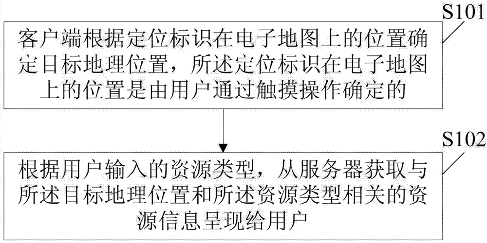
[0061] See figure 1 , is a flow chart of the first embodiment of the LBS-based resource information presentation method provided by the present invention, and the method includes:

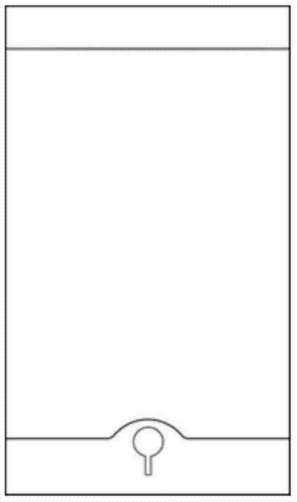
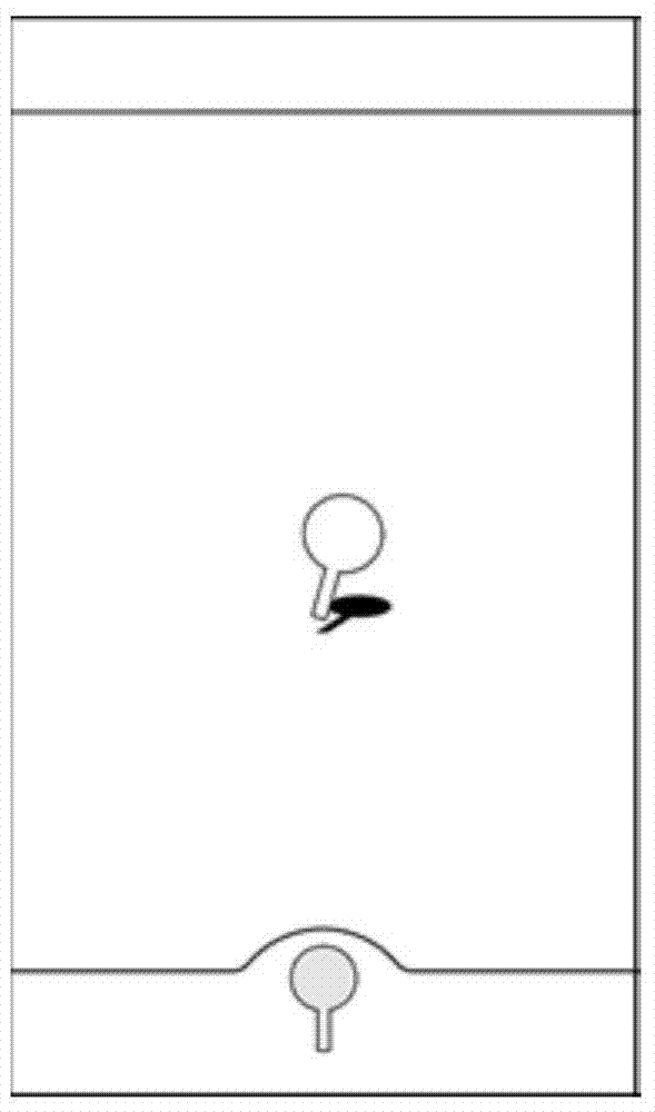
[0062] S101. The client terminal determines the target geographic location according to the position of the positioning mark on the electronic map, and the position of the positioning mark on the electronic map is determined by a user through a touch operation. Existing smartphones, tablet computers, etc. generally use touch screen control. In order to meet the needs of users, preferably, the positioning mark is designed as a touch-type pin, and the touch-type pin is placed in the pin slot (such as Figure 2A shown), the position of the positioning mark on the electronic map is that the user drags the touch pin from the pin slot to the electronic map (such as Figure 2B shown) and release the touch pins (as Figure 2C shown), the position of the touch pin on the electronic map. Specifically, whe...

no. 2 example

[0065] See image 3 , is a flow chart of the second embodiment of the LBS-based resource information presentation method provided by the present invention, and the method includes:

[0066] S301. The client terminal determines the target geographic location according to the position of the positioning mark on the electronic map, and the position of the positioning mark on the electronic map is determined by the user through a touch operation.

[0067] S302. Determine a scanning area according to the target geographic location and a preset scanning size. For example, a circular area with the target geographic location as the center and a preset scanning size as the radius may be used as the scanning area. For another example, a square area with the target geographic location as the center and a preset scan size as the side length may be used as the scan area. Among them, the scanning size can be set and modified by the user, that is to say, the scanning area is adjustable.

...

no. 3 example

[0070] See Figure 4 , is a flow chart of the third embodiment of the LBS-based resource information presentation method provided by the present invention, and the method includes:

[0071] S401. The client terminal determines the target geographic location according to the position of the positioning mark on the electronic map, and the position of the positioning mark on the electronic map is determined by the user through a touch operation.

[0072] S402. The client terminal determines a scanning area according to the target geographic location and a preset scanning size.

[0073] S403. The client sends a resource query request to the server according to the scanning area and the resource type input by the user.

[0074] S404. The server searches the database for resource information related to the resource type in the scan area according to the resource query request, and the resource information related to the resource type includes target resource data under the resource...


PUM


Abstract

The invention discloses a resource information presentation method, device and system based on location based service (LBS). The method comprises the steps: according to the position of positioning identification on an electronic map, determining the objective geographic position by a client, wherein the position of positioning identification on the electronic map is determined through the touch operation by a user; and according to the resource type input by the user, obtaining the resource information related to the objective geographic position and the resource type from a server and presenting to the user by the client. The method allows the user to directly determine the objective geographic position on the electronic map by using the touch operation, rather than the user current position is simply used as the objective geographic position, and the user does not need to manually input the characters to determine the objective geographic position, and the user does not need to select the objective geographic position passively according to the tiled list provided by a developer, so the diversified requirement of the user to the resource information can be satisfied.

Description

technical field [0001] The present invention relates to LBS (Location Based Service, location-based service) technology, in particular to an LBS-based resource information presentation method, device and system. Background technique [0002] In the LBS application, if the user wants to obtain resource information in a certain geographical area, such as rental housing, second-hand housing, group buying, movies, etc., the user needs to determine the target geographic location through the client, and then send the coordinate data of the target geographic location to the background server. The background server is responsible for determining the data that can be collected with the received coordinates and a certain range of reference coordinates. Then the resource information corresponding to the collected data is obtained through the database. After obtaining the resource information, the server feeds back the resource information to the client, and the client parses the rece...

Claims


Application Information

Patent Timeline
Patent Type & Authority Applications(China)
IPC IPC(8): G06F17/30
Inventor 郭予靖肖皓天
Owner 曾方颖
Why Eureka
Try Eureka