Spatial knowledge service system building method based on collaborative plotting technology

A collaborative plotting and knowledge service technology, which is applied in the field of visual expression of information in hotspot areas, can solve the problems of restricting the development of social application of spatial information, openness restrictions, and low service level, so as to improve the utilization rate of spatial data, The effect of getting rid of the silo effect and enhancing the ability of collaboration and communication

Inactive Publication Date: 2015-07-22
BEIJING AEROSPACE TITAN TECH CO LTD
View PDF3 Cites 26 Cited by
  • Summary
  • Abstract
  • Description
  • Claims
  • Application Information

AI Technical Summary

Problems solved by technology

At present, domestic Internet map drawing is limited to point of interest labeling, and has a complicated review process; while foreign countries have more content collaborative drawing functions, such as Google Map Maker of Google Maps and Waze map service acquired by Google.
Unfortunately, its openness is subject to many restrictions, and users often cannot obtain sufficient freedom for drawing network maps
[0006] However, my country's spatial knowledge information is not rich enough, and the service level remains at a low level, which has begun to restrict the development of social application of spatial information, which urgently requires my country to further increase spatial knowledge mining and service levels

Method used


Image

  • Spatial knowledge service system building method based on collaborative plotting technology
  • Spatial knowledge service system building method based on collaborative plotting technology
  • Spatial knowledge service system building method based on collaborative plotting technology

Examples


Embodiment Construction

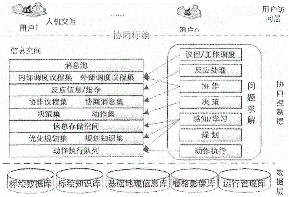
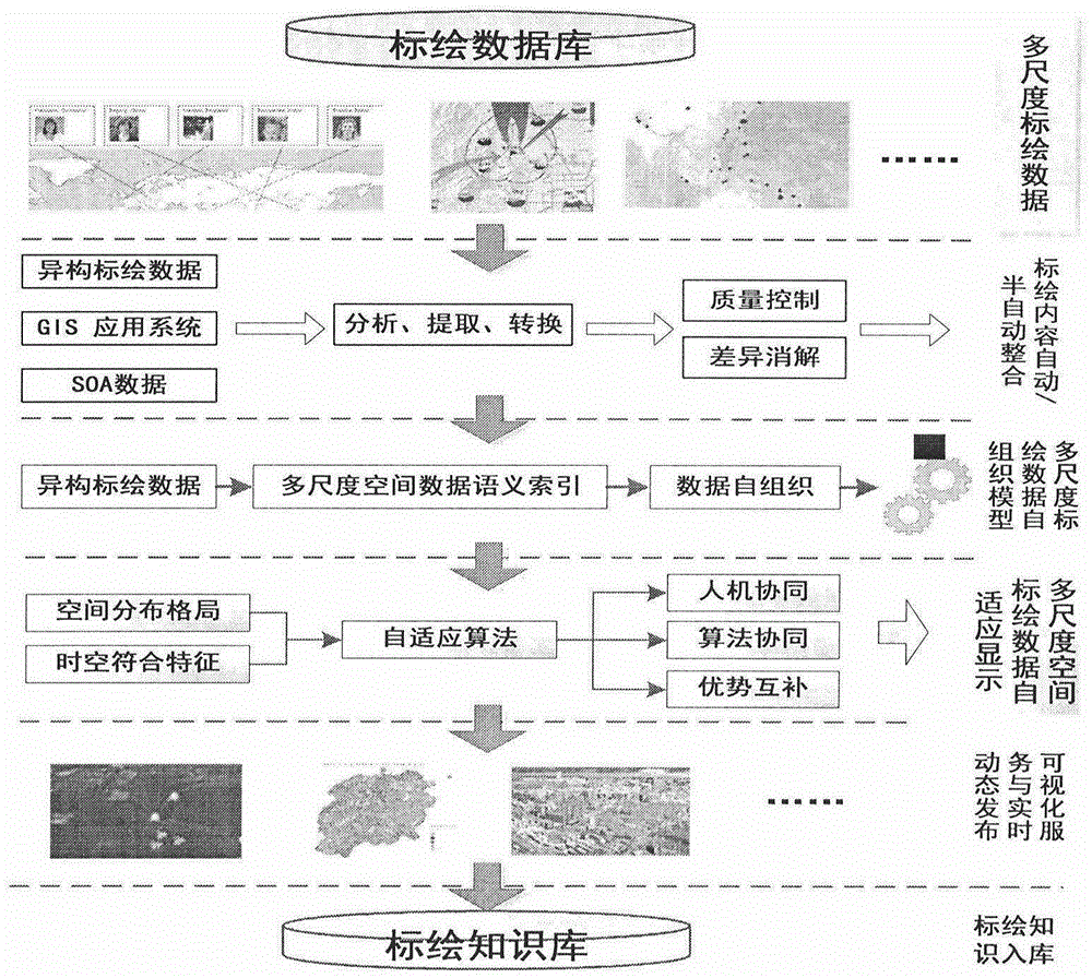
[0101] 1. Collaborative plotting

[0102] 1. Classification of plotted content

[0103] ●Picture plotting

[0104] The user can select a picture plot on the plot layer and select the corresponding icon. The icons currently support common picture formats such as png, jpg, and gif.

[0105] ●flash plotting

[0106] The user can select flash plotting on the plotting layer, and select the corresponding flash animation file. The temporarily supported format is swf file.

[0107] ●Audio plotting

[0108] Users can select audio plotting on the plotting layer, and select the corresponding audio icon. Icons currently support common image formats such as png, jpg, and gif. The corresponding audio can then be selected and uploaded.

[0109] ●Text Plotting

[0110] The user can click the position to be plotted on the plotting layer, click the left button of the mouse to start text input, adjust the size, font, and color of the text, and click OK to save the input text information. ...


PUM


Abstract

The invention discloses a global dynamic heterogeneous spatial information collaborative plotting and spatial knowledge service system. On the basis of plotting data obtained by a collaborative plotting platform, mass related heterogeneous spatial information of Africa is collected, and a plotting knowledge base is generated through data integration and knowledge reasoning; on the basis of the plotting knowledge base, a knowledge model is built by means of data mining, hot spot image-text association and the like, knowledge services with the text that 'a Chinese is attacked in Africa', and the texts of 'China-Africa international cooperation', 'Africa travel' and the like being themes are carried out, visual representation is performed on hot spot area information by means of hot spot image-text generation, network map diaries and the like, a knowledge base (stored data) is built, finally, the African spatial knowledge service system based on the collaborative plotting technology is achieved, and spatial information active services are provided for the public, the government and associated users.

Description

technical field [0001] Based on the global dynamic heterogeneous spatial information collaborative plotting and spatial knowledge service system, the present invention collects a large amount of related heterogeneous spatial information in Africa, and through data integration and knowledge reasoning, visually expresses the information of hotspot areas to realize the generation and release of hotspot images and texts. The construction of the African spatial knowledge service system belongs to the field of GIS spatial analysis application technology, and provides active spatial information services for the public, government and other relevant users. Background technique [0002] With the rapid development of information technology and Internet technology, the amount of information that people come into contact with is increasing. The information service process is actually a process of disseminating information, exchanging information, and making information more valuable. T...

Claims


Application Information

Patent Timeline
Patent Type & Authority Applications(China)
IPC IPC(8): G06F17/30G06Q10/06
Inventor 倪金生刘翔赵国英
Owner BEIJING AEROSPACE TITAN TECH CO LTD
Why Eureka
Try Eureka