Urban vegetation automatic extraction method of multiple-spatial resolution remote sensing image

A remote sensing image, multi-resolution technology, applied in the field of remote sensing images, can solve the problems of low degree of automation, manual interaction selection, affecting the degree of automation of vegetation extraction, etc.

Inactive Publication Date: 2015-08-19
HUAZHONG AGRI UNIV +1
View PDF6 Cites 22 Cited by
  • Summary
  • Abstract
  • Description
  • Claims
  • Application Information

AI Technical Summary

Problems solved by technology

[0007] (2) The degree of automation is not high
In the classification process, the segmentation scale, threshold and features of vegetation classification all need to be selected manually. These intermediate processes seriously affect the automation of vegetation extraction.
In addition, in the segmentation process, the same threshold is used for the entire image, which does not fully consider the differences between different vegetation types (such as grassland, coniferous forest, broad-leaved forest, etc.) on the image.
[0008] (3) Only the multispectral data in the high spatial resolution image is used, and the characteristics of the panchromatic band with higher spatial resolution are not utilized. Multispectral imagery is bundled together
Only the multispectral data in high spatial resolution images are used, and the characteristics of panchromatic bands with higher spatial resolution are not used. In practice, remote sensing data such as WorldView, QuickBird and other high spatial resolution panchromatic and multispectral images is tied together

Method used


Image

  • Urban vegetation automatic extraction method of multiple-spatial resolution remote sensing image
  • Urban vegetation automatic extraction method of multiple-spatial resolution remote sensing image
  • Urban vegetation automatic extraction method of multiple-spatial resolution remote sensing image

Examples


Embodiment Construction

[0075] In order to make it easier for those skilled in the art to understand and implement the present invention, the present invention will be further described in detail below in conjunction with the accompanying drawings and specific embodiments.

[0076] This program automatically extracts urban vegetation areas for high-resolution remote sensing images with panchromatic and multispectral bands such as IKONOS, QuickBird, and WorldView. Specific steps include:

[0077] Step 1. Extraction of initial patches of vegetation based on high spatial resolution multispectral images.

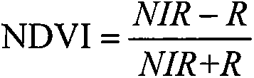
[0078] Calculate the NDVI vegetation spectral index. See (1) for the specific calculation formula.

[0079] NDVI = NIR - R NIR + R - - - ( 1 )

[0080] Among them, NIR r...


PUM


Abstract

The present invention discloses an urban vegetation automatic extraction method of multiple-spatial resolution remote sensing images. The method comprises the steps of extracting vegetation initial plaques based on high-spatial resolution multispectral images, calculating visual perception parameters for the high-spatial resolution multispectral images, calculating textural feature parameters for high-spatial resolution panchromatic Images, automatic growing of multi-feature comprehensive vegetation regions, and obtaining a vegetation region distribution map. With adoption of image sectional division treatment, the image processing speed is accelerated. According to normalized difference vegetation index (NDVI) features, automatic selection of maximal mathematical expectation algorithm adaptive dynamic thresholds is adopted. Panchromatic wave bands and multi-spectrum wave bands of the remote sensing images are fully utilized, the NDVI features, visual features and textural features of the panchromatic wave bands and multi-spectrum wave bands are synthesized, vegetation region judgment is performed on the vegetation, and the accuracy is raised.

Description

technical field [0001] The invention relates to a method for automatically extracting urban vegetation from multi-resolution remote sensing images, belonging to the field of remote sensing images. Background technique [0002] Urban vegetation has the functions of carbon sequestration and release, and plays an important role in maintaining the urban ecological environment. Urban vegetation coverage based on high-resolution remote sensing images is an important indicator for evaluating ecological cities and garden cities. At present, there are mainly the following methods for extracting urban vegetation from high-resolution remote sensing images: [0003] (1) Manual visual interpretation and interpretation. This method mainly uses manual interpretation of the vegetation area, and then draws the boundary of the vegetation. In visual interpretation, the characteristics of vegetation in the image mainly include shape, size, color and tone, shadow, position, texture relationsh...

Claims


Application Information

Patent Timeline
Patent Type & Authority Applications(China)
IPC IPC(8): G06T7/40G06K9/46
Inventor 佃袁勇姚崇怀徐永荣周志翔
Owner HUAZHONG AGRI UNIV
Why Eureka
Try Eureka