Cross-terminal self-adaptation visual electronic map implementation method based on pure network script languages

An electronic map and implementation method technology, applied in the field of network geographic information systems, can solve the problems of labor-intensive, unable to maintain the unified style and performance of WebGIS maps, and achieve the effects of quick start, improved upgrade and maintenance efficiency, and shortened development time.

Inactive Publication Date: 2015-09-02
BEIJING GREATMAP TECH
View PDF5 Cites 5 Cited by
  • Summary
  • Abstract
  • Description
  • Claims
  • Application Information

AI Technical Summary

Problems solved by technology

[0003] The present invention provides a cross-terminal self-adaptive visual electronic map realization method based on pure network scripting language, which is used to overcome the disadvantages in the prior art that are labor-intensive and cannot maintain the unified style and performance of WebGIS maps

Method used


Image

  • Cross-terminal self-adaptation visual electronic map implementation method based on pure network script languages

Examples


Embodiment Construction

[0020] The following will clearly and completely describe the technical solutions in the embodiments of the present invention with reference to the accompanying drawings in the embodiments of the present invention. Obviously, the described embodiments are only some, not all, embodiments of the present invention. Based on the embodiments of the present invention, all other embodiments obtained by persons of ordinary skill in the art without making creative efforts belong to the protection scope of the present invention.

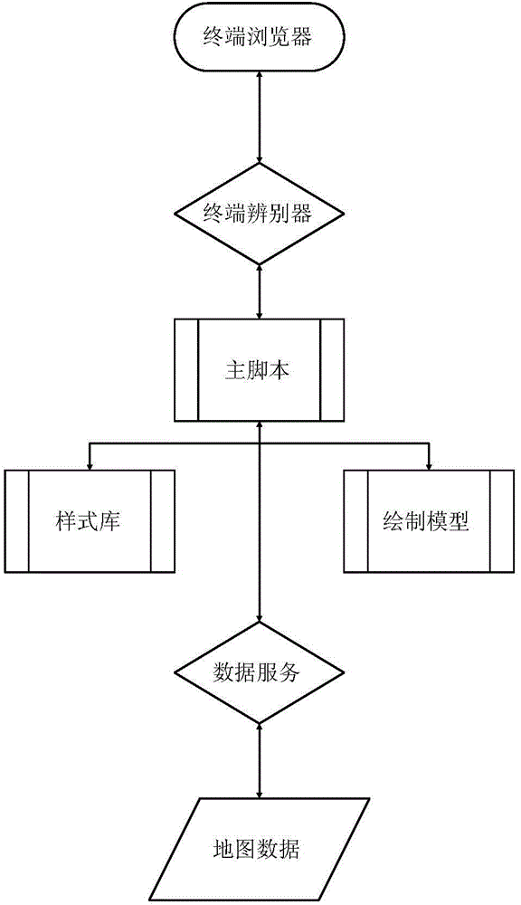
[0021] The implementation process of the present invention is that if you want to realize the self-adaptation of the same program on different terminals, you first need to find a development language that can run on different terminals and different operating systems. This language is the network scripting language. The reason why this judgment is made It is because all kinds of smart terminals, whether it is PC, mobile phone or Pad, are pre-installed with brow...


PUM


Abstract

The invention discloses a cross-terminal self-adaptation visual electronic map implementation method based on pure network script languages. The method includes: receiving an electronic map acquiring request transmitted by a user terminal browser, and distinguishing the type of a user terminal according to the electronic map acquiring request, wherein the electronic map acquiring request contains information for identifying the type of the user terminal and the requested map data information; calling a main script file, acquiring the presenting style library corresponding to the type of the user terminal through the main script file, and calling a vector drawing model matched with the type of the user terminal through the main script file; requesting a rear-end map database to obtain the requested map data through the main script file; transmitting the acquired matching script, the presenting style library, the vector drawing model and the requested map data to the browser of the user terminal for map presenting.

Description

technical field [0001] The invention relates to the field of network geographic information systems, in particular to a method for realizing a cross-terminal self-adaptive visualized electronic map based on a pure network script language. Background technique [0002] In the existing WebGIS field, different terminals need to develop separate WebGIS map software according to the characteristics of each terminal (ie, its display processing capabilities, etc.). The application of different terminals is mainly through the use of different terminals Different development languages ​​that can be used in different development languages, develop applications that adapt to different terminals and corresponding operating systems, such as: PC-side services, mobile phone APPs, Pad-side APPs, etc., and will develop correspondingly according to different operating systems of different terminals, such as : mobile terminal Android system and IOS system, the shortcomings of this adaptation m...

Claims


Application Information

Patent Timeline
Patent Type & Authority Applications(China)
IPC IPC(8): G06F17/30
Inventor 陈菡王嘉欧翔
Owner BEIJING GREATMAP TECH
Why Eureka
Try Eureka