Road surface spectrum and GIS vector data fusion method and system based on semantic technology

A semantic technology, vector data technology, applied in electrical digital data processing, special data processing applications, instruments, etc., can solve the problem of lack of elevation information, achieve the effect of simple and effective operation, ensure consistency, and solve the problem of semantic errors

Inactive Publication Date: 2015-09-09
JIANGSU UNIV OF SCI & TECH
View PDF5 Cites 3 Cited by
  • Summary
  • Abstract
  • Description
  • Claims
  • Application Information

AI Technical Summary

Problems solved by technology

Two-dimensional vector data set is the core data of geographic information system (GIS). Two-dimensional vector data is generally used to represent graphic data such as cities, rivers, national boundaries, roads, railways, regions, terrains, etc. These data are very suitable for spatial analysis operations , but without elevation information

Method used


Image

  • Road surface spectrum and GIS vector data fusion method and system based on semantic technology
  • Road surface spectrum and GIS vector data fusion method and system based on semantic technology
  • Road surface spectrum and GIS vector data fusion method and system based on semantic technology

Examples


Embodiment Construction

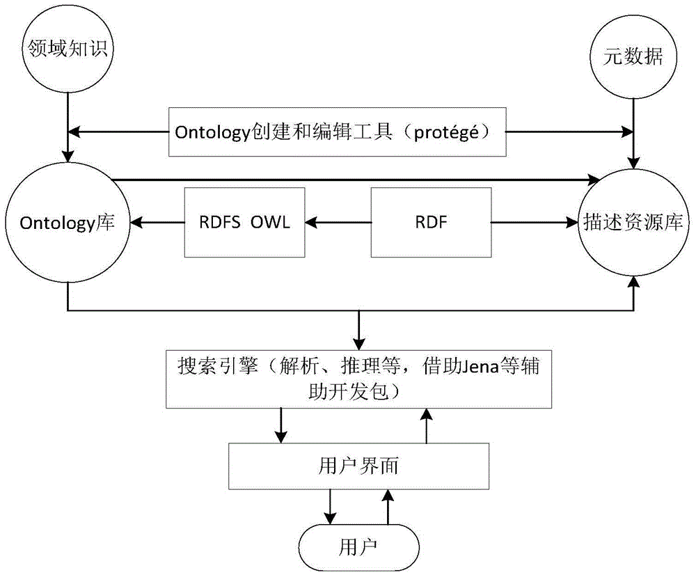
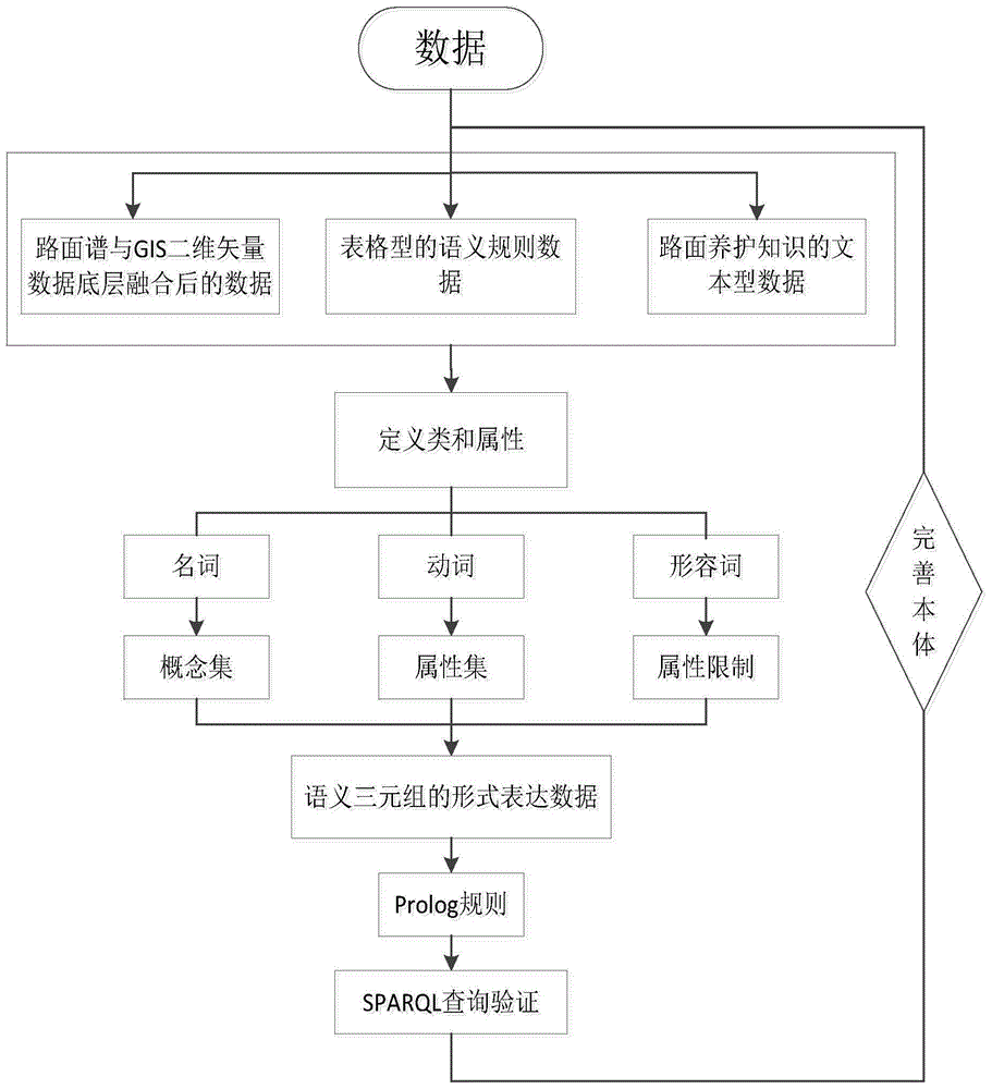
[0028] Such as figure 1 As shown, the fusion method of road spectrum and GIS vector data based on semantic technology and the whole frame diagram of the system, the fusion system of the fusion method of road spectrum and GIS vector data based on semantic technology, consists of the underlying data fusion module, the semantic technology-based It consists of a fusion module and a query interface module. Among them, the fusion module based on semantic technology includes a semantic ontology establishment module, an analysis reasoning module and other parts. Formulate reasoning rules based on the established semantic ontology, so as to retrieve semantically compliant data from metadata and output it on the user interface.

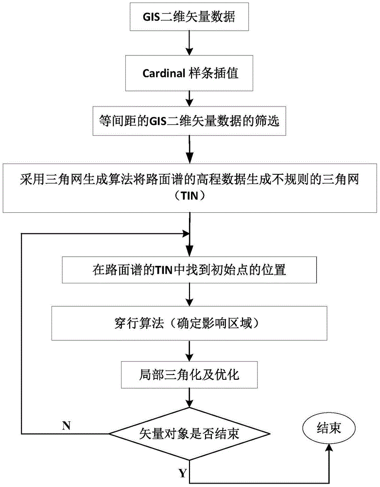
[0029] The underlying data fusion module can fuse road spectrum data with GIS two-dimensional vector data. The fused road spectrum data does not change in shape, and at the same time, it can expand the two-dimensional vector data in dimension and increase eleva...


PUM


Abstract

The present invention relates to a road surface spectrum and GIS vector data fusion method and system based on a semantic technology. According to the method, firstly, a great quantity of ordered interpolating points are calculated by a Cardinal cubic spline curve interpolation algorithm; then points, of which the number is the same with sampling times of a road surface spectrum, are selected at an equal interval from an interpolated point sequence; altitude data of the road surface spectrum is processed by adopting a triangulation network generating algorithm to construct an irregular triangulation network and then GIS two-dimensional vector data is fused into the constructed triangulation network by an embedding algorithm; and next, semantic ontologies are established, according to extracted semantic rules and data fused on the bottom layer, by protege, inference rules are made by the logical relationship between the ontologies and data according with semantics is retrieved from metadata to be output on a query interface. The system consists of a data fusion module on the bottom layer, a fusion module based on the semantic technology, and a query interface module. According to the present invention, a user can know the real condition of a pavement and high-quality data services are provided for realizing intelligent transportation.

Description

technical field [0001] The invention belongs to the data fusion considering real ground objects, in particular relates to the data fusion combining semantic technology and reasoning, and in particular relates to a fusion method and system of road spectrum and GIS vector data based on semantic technology. Background technique [0002] With the rapid development of my country's economy, the demand for small and medium-sized cars in my country has been increasing year by year. According to the data of China Association of Automobile Manufacturers, the output of automobiles in 2012 has exceeded 19 million, a record high in the world, and it has once again ranked first in the world. The investment in road transportation infrastructure, which is closely related to the automobile industry, has also increased year by year, and the total number of roads has continued to grow. The road quality inspection is the key link of the whole road acceptance. The pavement spectrum data used to...

Claims


Application Information

Patent Timeline
Patent Type & Authority Applications(China)
IPC IPC(8): G06F17/30
Inventor 刘庆华刘双双陶峰
Owner JIANGSU UNIV OF SCI & TECH
Why Eureka
Try Eureka