Three-dimensional Douglas-Peucker algorithm based map simulation method for synchronous integration of river network elements and DEM

A simulation method and river network technology, applied in computing, 3D modeling, image data processing, etc., can solve problems such as out-of-synchronization of operations, analysis of geometric or topological contradictions in operations, and achieve quality improvement, quality improvement, and good experimental results Effect

Inactive Publication Date: 2015-10-14
CHINA UNIV OF MINING & TECH (BEIJING) +1
View PDF3 Cites 10 Cited by
  • Summary
  • Abstract
  • Description
  • Claims
  • Application Information

AI Technical Summary

Problems solved by technology

[0004] In order to solve the problem that the two elements of the river network and the DEM data are independently and comprehensively operated, and the operation is not synchronized, it is easy to cause geometric or topological contradictions in the analysis operation, and a river network element based on the three-dimensional Douglas-Peucker algorithm is proposed. Synchronous Synthetic Map Simulation Method with DEM

Method used


Image

  • Three-dimensional Douglas-Peucker algorithm based map simulation method for synchronous integration of river network elements and DEM
  • Three-dimensional Douglas-Peucker algorithm based map simulation method for synchronous integration of river network elements and DEM
  • Three-dimensional Douglas-Peucker algorithm based map simulation method for synchronous integration of river network elements and DEM

Examples


specific Embodiment approach 1

[0038] Specific embodiment one: a kind of synchronous comprehensive map simulation method of the river network elements and DEM based on the three-dimensional Douglas-Peucker algorithm of the present embodiment is specifically prepared according to the following steps:

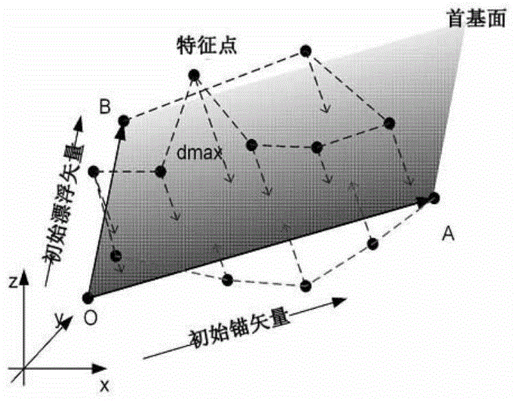
[0039] Step 1. According to the high dependence of the river network on the terrain, extract the river network data and DEM data into three-dimensional discrete point data sets, combine them into the same data set, and then use the improved 3D_DP algorithm for comprehensive operation; the specific comprehensive process is as follows Figure 4 As shown; the river network two-dimensional vector line data is hierarchically selected according to the river network comprehensive selection method, and the selected river network two-dimensional vector line data is extracted into a river network two-dimensional discrete point set, and the elevation attribute is added. Become a three-dimensional discrete point set of the...

specific Embodiment approach 2

[0061] Specific implementation mode two: the difference between this implementation mode and specific implementation mode one is: the river network comprehensive selection method in step one is specifically:

[0062] (1) Calculate the comprehensive index of each river according to formula (3). The selection of rivers is a complicated problem. There are many classic river selection methods at present; the main criterion is the length of the river, supplemented by the river network density and Standards such as level are combined, thereby carry out the calculation of the comprehensive index of river; The present invention has quoted this method;

[0063] Comprehensive index = length × grade α ×(max level-level+1) β (3)

[0064] Among them, the level indicates the river density; the level value depends on the tree structure of the river system, the level value of the mainstream is 1, and the level value gradually increases from the mainstream to the tributary and then to the...

specific Embodiment approach 3

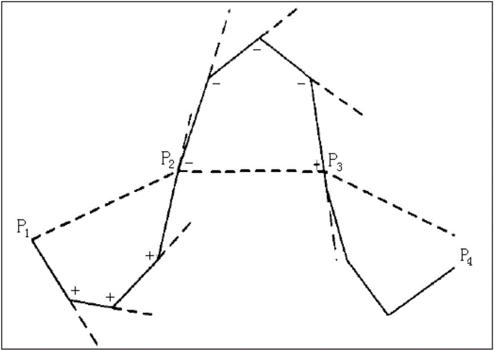
[0067] Embodiment 3: The difference between this embodiment and Embodiment 1 or 2 is that in step 4, the 3D_DP improved by the bending adjustment index, that is, the three-dimensional Douglas-Peucker algorithm, is used to comprehensively operate the merged data set in step 3, and the operation must be followed. The specific rules are:

[0068] The corresponding river synthesis rules need to be added, that is, after the river network is hierarchically selected, the rivers that have been preserved should not be completely simplified during the synthesis due to the large threshold of the 3D_DP algorithm, etc., so formulate the following rules (1) When comprehensive operations are performed at each level of the river network, the starting and ending points of the mainstream and tributaries of all river systems at each level of the river network must be preserved; (2) the intersections of all mainstreams and tributaries at each level of the river network must also be preserved. Oth...


PUM


Abstract

A three-dimensional Douglas-Peucker algorithm based map simulation method for synchronous integration of river network elements and a DEM is provided, and the present invention relates to a map simulation method for synchronous integration of river network elements and a DEM. The present invention solves the problem that integration operations of river network and DEM data are not synchronous. The method provided by the invention is realized through the following steps of: 1, after performing hierarchical grading on a river network, and extracting a river network three-dimensional discrete point set; 2, extracting a three-dimensional discrete point set from a DEM; 3, combining the data point sets; 4, performing an integration operation on the combined data set by using a three-dimensional Douglas-Peucker algorithm that is improved by a bend adjustment index, to obtain an integrated data set; 5, re-separating the integrated data set according to a point set attribute; and 6, reconstructing a triangulation network on a DEM point set by using river line segments as constraint edges, to realize steps such as synchronous integration and expression of the two elements. The method provided by the present invention is applied to a three-dimensional geographic information system mapping and integration field.

Description

technical field [0001] The invention relates to a synchronous comprehensive map simulation method of river network elements and DEM, in particular to a synchronous comprehensive map simulation method of river network elements and DEM based on a three-dimensional Douglas-Peucker algorithm. Background technique [0002] Douglas-Peucker (DP) algorithm is currently the most representative algorithm for simplification of two-dimensional linear elements. At present, some scholars have extended it from 2D to 3D, proposed a 3D Douglas-Peucker algorithm (hereinafter referred to as 3D_DP algorithm), and applied it to the synthesis of DEM; the existing technology has improved the algorithm. Subsequently, the 3D_DP algorithm has been widely used in many fields, such as the geomorphic synthesis of the Loess Plateau, the indirect synthesis of contour lines, the extraction of DEM terrain features, the LOD modeling of regular grid terrain, and the thinning of seabed multi-beam bathymetry da...

Claims


Application Information

Patent Timeline
Patent Type & Authority Applications(China)
IPC IPC(8): G06T17/05
Inventor 窦世卿赵学胜刘成军林亚文张红华
Owner CHINA UNIV OF MINING & TECH (BEIJING)
Why Eureka
Try Eureka