Power network geographic information system (GIS) based mobile terminal collaborative plotting method

A collaborative plotting, mobile terminal technology, applied in ICT adaptation, electronic digital data processing, structured data retrieval, etc., can solve collaborative plotting delays, cannot meet the real-time plotting needs of on-site emergency personnel, and inaccurate plotting information, etc. problem, to achieve the effect of low loss rate

Active Publication Date: 2015-11-18
山东弘石互联网科技有限公司
View PDF5 Cites 10 Cited by
  • Summary
  • Abstract
  • Description
  • Claims
  • Application Information

AI Technical Summary

Problems solved by technology

[0003] At present, the collaborative plotting based on power grid GIS is based on a fixed PC terminal, which cannot meet the real-time plotting needs of on-site emergency personnel anytime, anywhere
For complex electric power business, especially emergency incidents handled by multiple units, on-site emergency personnel can often get relevant information at the first time. The delay in collaborative plotting can also easily lead to inaccurate plotting information in the process of information transmission

Method used


Image

  • Power network geographic information system (GIS) based mobile terminal collaborative plotting method

Examples


Embodiment Construction

[0034] The present invention will be further described below in conjunction with the accompanying drawings and embodiments.

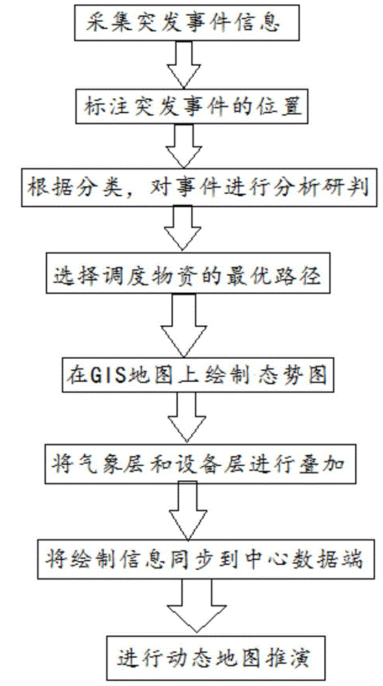
[0035] Such as figure 1 As shown, a mobile collaborative plotting method based on power grid GIS includes the following steps:

[0036] (1) Collect emergency event information and determine the location of the emergency event on the State Grid GIS map;

[0037] (2) Classify according to the needs, judge the type and level of the event, and analyze and judge the scope of the impact of the emergency and the equipment and facilities of the power grid;

[0038] (3) According to the six major categories and 22 subcategories of the incident, the early warning and response level of the incident, and the coordinating unit of the incident, determine the disaster scope of the incident and the type of materials to be called, and combine the GIS system to select the optimal path;

[0039] (4) According to the positioning information of electric power equipment an...


PUM


Abstract

The present invention discloses a power network geographic information system (GIS) based mobile terminal collaborative plotting method comprising the following steps: acquiring emergency information, and determining the location of an emergency on a power network GIS map; classifying according to needs, determining event types and ranks, and performing analysis, research and determination on influence scope of the emergency and power network equipment and facilities to select an optimal path; establishing an equipment map layer and a weather map layer respectively in the power network GIS map according to positioning information of electrical equipment and a weather monitoring station, superimposing the weather map layer and the equipment map layer, intuitively drawing a situation map on the GIS map, and synchronizing plotting information to a center data terminal; gathering and summarizing the plotting information by the center data terminal and then synchronously issuing the information to a collaborative plotting mobile terminal; and setting a playing time scale, playing a prearranged plan data and checking the situation at any time to perform dynamic map deduction. By adopting the power network GIS based mobile terminal collaborative plotting method, rich plotting languages including graphical plotting languages, symbolic plotting languages and the like are used for completely, comprehensively, accurately and timely showing emergency resource situations.

Description

technical field [0001] The invention relates to a mobile terminal collaborative plotting method based on power grid GIS. Background technique [0002] Situation plotting is a common function in application industries such as electric power repair, military command, forest firefighting, and earthquake emergency response. It is the basis for graphically expressing situation analysis, task deployment, and collaborative work. [0003] At present, the collaborative plotting based on power grid GIS is based on a fixed PC terminal, which cannot meet the real-time plotting needs of on-site emergency personnel anytime and anywhere. For complex electric power business, especially emergency incidents handled by multiple units, on-site emergency personnel can often get relevant information at the first time. The delay in collaborative plotting can also easily lead to inaccurate plotting information in the process of information transmission. Contents of the invention [0004] In ord...

Claims


Application Information

Patent Timeline
Patent Type & Authority Applications(China)
IPC IPC(8): G06F17/30G06Q10/04G06Q50/06
CPCG06F16/29G06Q10/047G06Q50/06Y02A90/10
Inventor 邓国强胡明磊陈萌王超
Owner 山东弘石互联网科技有限公司
Why Eureka
Try Eureka