Method and system for extracting region growing seed points based on remote sensing images and sea-land segmentation

A technology of sea and land segmentation and remote sensing images, which is applied in the field of remote sensing image processing, can solve the problem of non-adaptive algorithms, achieve the effect of improving algorithm efficiency and avoiding manual interaction

Active Publication Date: 2015-11-25
SPACE STAR TECH CO LTD
View PDF7 Cites 3 Cited by
  • Summary
  • Abstract
  • Description
  • Claims
  • Application Information

AI Technical Summary

Problems solved by technology

For example, Liu used neural networks to fuse texture features and grayscale information, and achieved good results for cell segmentation, but the algorithm is not self-adaptive and requires human interaction

Method used


Image

  • Method and system for extracting region growing seed points based on remote sensing images and sea-land segmentation
  • Method and system for extracting region growing seed points based on remote sensing images and sea-land segmentation
  • Method and system for extracting region growing seed points based on remote sensing images and sea-land segmentation

Examples


no. 1 example

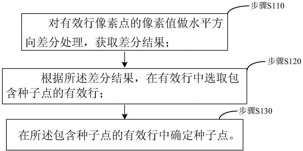
[0037] figure 1 It is the processing flowchart of the region growing seed point extraction method for sea-land segmentation of remote sensing images provided by Embodiment 1 of the invention. This embodiment provides the processing flow of the region growing seed point extraction method for sea-land segmentation of remote sensing images, as figure 1 As shown, the following according to figure 1 Each step of this embodiment will be described in detail.

[0038] The original image described in this embodiment is a grayscale image collected; in the original image, the following steps are performed:

[0039] Step S110, performing horizontal difference processing on the pixel values ​​of the pixel points in the effective row to obtain the difference result;

[0040] Step S120, according to the difference result, select an effective row containing the seed point among the effective rows;

[0041] Step S130, determining a seed point in the valid row containing the seed point.

no. 2 example

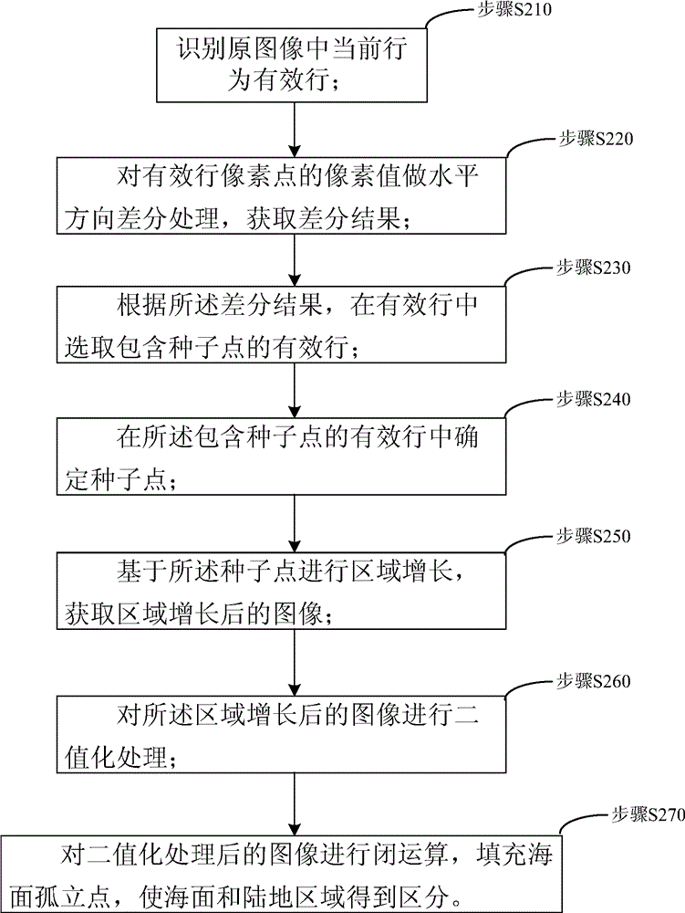
[0043] figure 2 It is the processing flowchart of the region growing seed point extraction method for sea-land segmentation of remote sensing images provided by Embodiment 1 of the invention. This embodiment provides the processing flow of the region growing seed point extraction method for sea-land segmentation of remote sensing images, as figure 2 As shown, the following according to figure 2 Each step of this embodiment will be described in detail.

[0044] Step S210, identifying the current active line in the original image;

[0045] A method for identifying valid lines of the current behavior in the original image, including:

[0046] Perform the following operations on the obtained original image line by line:

[0047] Extract the pixel value of each pixel point in the current row from the obtained original image, and arrange them sequentially to form a one-dimensional array;

[0048] If the number of invalid pixels in the one-dimensional array of pixels is greate...

no. 3 example

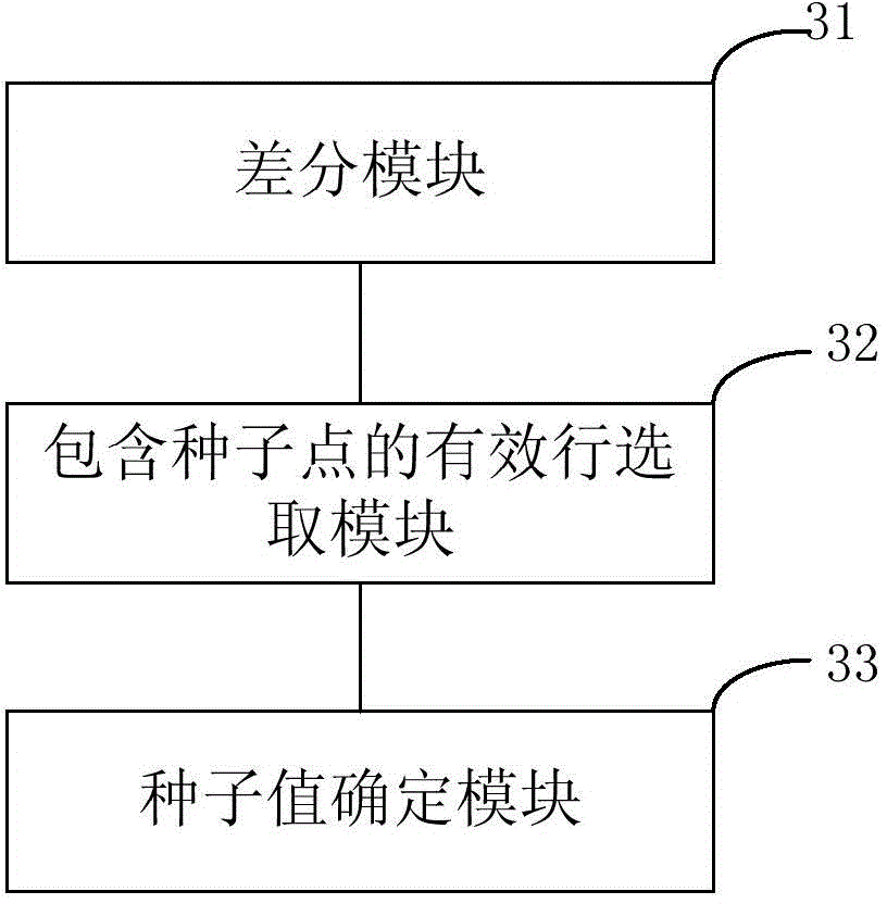
[0088] image 3 It is the block diagram of the region growing seed point extraction system for sea-land segmentation of remote sensing images provided by Embodiment 3 of the invention. This embodiment provides a region growing seed point extraction system for sea-land segmentation of remote sensing images, as image 3 As shown, according to the following image 3 Each module of this embodiment will be described in detail.

[0089] The region growing seed point extraction system for sea-land segmentation of remote sensing images includes a difference module 31, a valid line selection module 32 containing seed points and a seed value determination module 33, wherein,

[0090] A difference module 31, which is used to perform horizontal difference processing on the pixel values ​​of the effective row pixels to obtain the difference result;

[0091] Further, once the effective line in the original image is identified as an effective line, immediately use the difference module 31 ...


PUM


Abstract

The invention discloses a method for extracting region growing seed points based on remote sensing images and sea-land segmentation. The method includes: performing horizontal direction difference treatment on pixel values of pixel points of effective rows and obtaining a difference result; according to the difference result, selecting the effective row including the seed points from the effective rows; and determining the seed points in the effective row including the seed points. The seed points are automatically obtained by using scan image data and based on a pixel gradient method. The artificial interaction is avoided, and the algorithm efficiency is improved.

Description

technical field [0001] The invention relates to the field of remote sensing image processing, in particular to a region growing seed point extraction method and system for sea and land segmentation of remote sensing images. Background technique [0002] With the continuous enhancement of remote sensing image data acquisition ability and the improvement of its resolution, it is imminent to utilize and develop remote sensing image interpretation technology. Among them, the use of remote sensing data for ship target detection has great practical significance in both civilian and military fields. [0003] Since visible light images have obvious advantages in showing details such as the shape, structure, texture, and color of ground targets, they can better detect, classify, and identify targets, and use satellite visible light images to monitor, detect, and identify ground targets, especially maritime targets. Detection is a growing concern. The detection and separation of oce...

Claims


Application Information

Patent Timeline
Patent Type & Authority Applications(China)
IPC IPC(8): G06K9/00G06K9/36G06K9/46
Inventor 王健邹同元李驰王振飞
Owner SPACE STAR TECH CO LTD
Why Eureka
Try Eureka