Ground point target push-scanning imaging task parameter spaceborne solving method

A ground target and ground point technology, applied in the field of aerospace remote sensing imaging tasks, can solve the problems of being unable to deal with newly discovered targets, and the inability of the satellite-ground link to achieve full-time interoperability, etc.

Active Publication Date: 2015-12-02
SHANGHAI SATELLITE ENG INST
View PDF2 Cites 16 Cited by
  • Summary
  • Abstract
  • Description
  • Claims
  • Application Information

AI Technical Summary

Problems solved by technology

Since the satellite-ground link cannot achieve full-time interoperab

Method used


Image

  • Ground point target push-scanning imaging task parameter spaceborne solving method
  • Ground point target push-scanning imaging task parameter spaceborne solving method
  • Ground point target push-scanning imaging task parameter spaceborne solving method

Examples


Embodiment Construction

[0095] The present invention will be described in detail below in conjunction with specific embodiments. The following examples will help those skilled in the art to further understand the present invention, but do not limit the present invention in any form. It should be pointed out that for those of ordinary skill in the art, a number of modifications and improvements can be made without departing from the concept of the present invention. These all belong to the protection scope of the present invention.

[0096] The on-board method for solving the parameters of a push-broom imaging task for a ground point target according to the present invention includes the following steps:

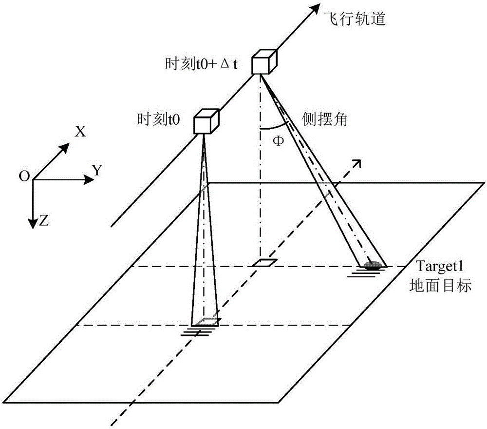
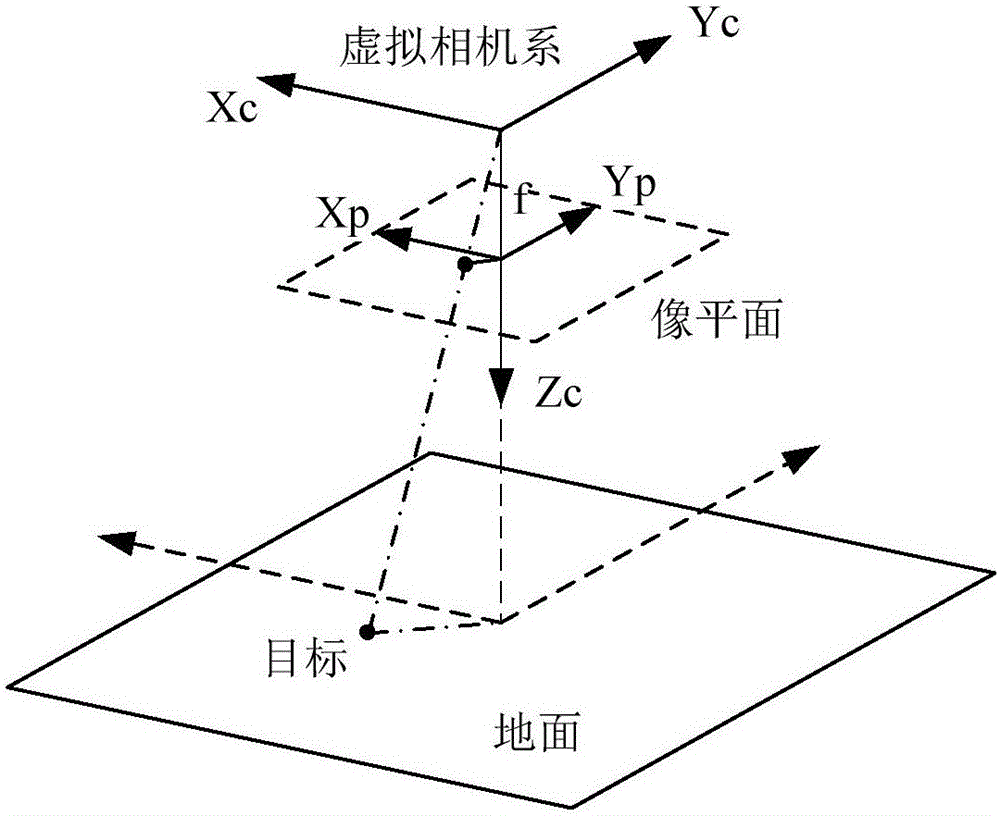
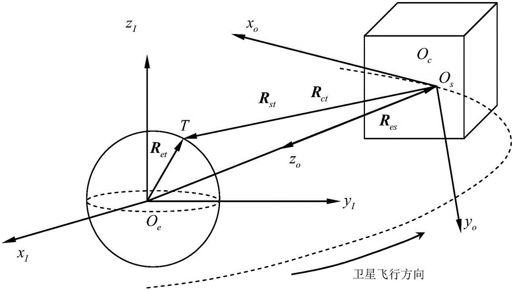
[0097] Step 1: Establish a coordinate system, the coordinate system includes the instantaneous inertial coordinate system, the satellite orbit coordinate system, the satellite body coordinate system, the virtual camera coordinate system, and the virtual image plane coordinate system, and define the rela...


PUM


Abstract

The invention provides a ground point target push-scanning imaging task parameter spaceborne solving method. The method comprises 1, building a coordinate system and defining vectors of a satellite, a ground object and the earth's core, 2, building an optical system equivalent optical path with a scanning mirror, 3, acquiring sub-satellite point solar altitude information, a satellite position and ground target information, 4, solving motion state characterization parameters of the satellite and ground target in an instantaneous inertial coordinate system, 5, calculating an expression of ground target coordinates and rate of change over time in the instantaneous inertial coordinate system, 6, calculating an expression of ground target coordinates and rate of change over time in a satellite body coordinate system and 7, building a constraint equation and calculating imaging task parameters. After acquiring ground point target coordinates, the satellite in orbit can automatically, fast and accurately adjust a scanning mirror in real time so that the scanning mirror targets an object and thus object imaging is ensured.

Description

Technical field [0001] The invention relates to the technical field of aerospace remote sensing imaging missions, in particular to a spaceborne method for solving the parameters of a ground point target push-broom imaging mission. Background technique [0002] The push-broom imaging camera uses linear array delay integral as the receiver to solve the problem of insufficient light flux of traditional area array cameras through multiple exposures. Due to the limitation of the camera's field of view, it is necessary to image a specific target on the ground. According to the relative relationship between the star and the ground, it is often necessary to adjust the camera's pointing by attitude or camera swing. The adjusted field of view, as the satellite flies, will be able to capture specific ground targets at a certain moment. [0003] Traditional ground remote sensing satellites need to complete imaging of a specific area, usually through satellite-ground joint control. The target ...

Claims


Application Information

Patent Timeline
IPC IPC(8): G01C11/00
CPCG01C11/00
Inventor 崔本杰邓武东成飞范凯胡明亮陈占胜
Owner SHANGHAI SATELLITE ENG INST
Why Eureka
Try Eureka