Multi-mode satellite navigation-based parafoil flight path control system

A flight track and multi-mode satellite technology, applied in the field of parafoil flight track control system, can solve the problems of disregarding meteorological conditions and terrain environment, GPS navigation system is easy to fail, etc., to overcome the limitations of use and solve blindness , The effect of increasing the reachability rate

Active Publication Date: 2015-12-02
AEROSPACE LIFE SUPPORT IND LTD
View PDF5 Cites 19 Cited by
  • Summary
  • Abstract
  • Description
  • Claims
  • Application Information

AI Technical Summary

Problems solved by technology

[0006] The technical problem to be solved by the present invention is to provide a multi-mode satellite navigation system that uses a multi-mode satellite navigation system that is easy to fail due to the single GPS navigation system of parafoil control in the prior art, and does not consider the meteorological conditions and terrain environment. Parafoil Flight Track Control System Monitoring with Terrain Environment

Method used


Image

  • Multi-mode satellite navigation-based parafoil flight path control system
  • Multi-mode satellite navigation-based parafoil flight path control system
  • Multi-mode satellite navigation-based parafoil flight path control system

Examples


Embodiment Construction

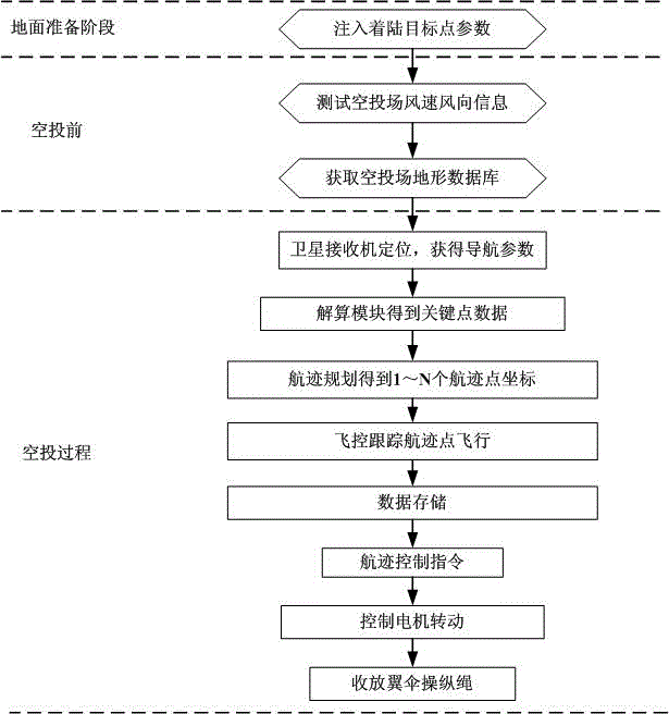
[0030] In order to make the object, technical solution and advantages of the present invention clearer, the present invention will be further described in detail below in conjunction with the accompanying drawings and embodiments. It should be understood that the specific embodiments described here are only used to explain the present invention, not to limit the present invention.

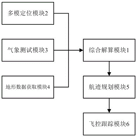
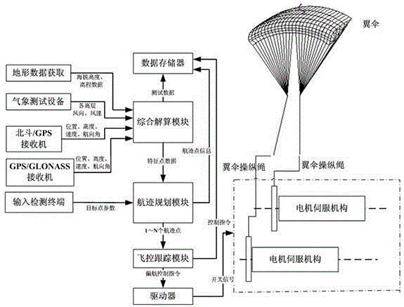
[0031] Such as figure 1 As shown, it is a system block diagram of the parafoil flight track control system adopting multi-mode satellite navigation of the embodiment of the present invention, including a comprehensive calculation module 1 arranged on the parafoil, and a multi-mode positioning module 2 and a multi-mode positioning module connected thereto. Track planning module 5, track planning module 5 is also connected with flight control tracking module 6; also includes meteorological test module 3 and terrain data acquisition module 4 arranged at the airdrop site.

[0032] The multi-mode posit...


PUM


Abstract

The present invention discloses a multi-mode satellite navigation-based parafoil flight path control system, which comprises a comprehensive solution module arranged on a parafoil, a multi-mode positioning module and a path planning module. The multi-mode positioning module and the path planning module are connected with the comprehensive solution module. The path planning module is also connected with a flight control tracking module. The system further comprises a meteorological testing module and a landform data acquisition module, wherein the meteorological testing module and the landform data acquisition module are arranged at an air-drop place. According to the technical scheme of the invention, the navigation reliability and the navigation precision are improved. At the same time, the blind-action problem during the conventional parafoil flight path control process can be solved. Therefore, the achievable rate of the landing precision is improved.

Description

technical field [0001] The invention relates to the field of parafoil control, in particular to a parafoil flight track control system using multi-mode satellite navigation. Background technique [0002] In the remote control airdrop system, firstly, the position, altitude, speed and other information of the airdrop system in the air are obtained through the navigation module. The track completes the flight. [0003] In the prior art, the parafoil flight track controller adopts a single GPS satellite positioning and navigation, and obtains navigation information by receiving GPS satellite signals for positioning calculation. A single GPS navigation control system can normally perform navigation and positioning functions under good conditions of use, such as open areas, no occlusion, stable system working conditions and no interference. However, due to the limitation of a single navigation system, when used in special environments such as limited use in local areas and exte...

Claims


Application Information

Patent Timeline
Patent Type & Authority Applications(China)
IPC IPC(8): G05D1/10
Inventor 刘琦张芃贺喜万天军
Owner AEROSPACE LIFE SUPPORT IND LTD
Why Eureka
Try Eureka