
Method for realizing outer space use positioning by earth GNSS satellites

An outer space and satellite technology, applied in the field of satellite positioning, can solve the problems of low accuracy of ultra-long-distance positioning, and achieve the effect of eliminating clock errors and improving positioning accuracy

Inactive Publication Date: 2015-12-16
BEIHANG UNIV
View PDF4 Cites 9 Cited by
  • Summary
  • Abstract
  • Description
  • Claims
  • Application Information

AI Technical Summary

Problems solved by technology

[0025] In view of this, the embodiment of the present invention provides a method for realizing outer space user positioning by earth GNSS satellites, which can solve the technical problems of existing GNSS ultra-long-distance positioning accuracy and low accuracy

Method used


Image

  • Method for realizing outer space use positioning by earth GNSS satellites
  • Method for realizing outer space use positioning by earth GNSS satellites
  • Method for realizing outer space use positioning by earth GNSS satellites

Examples


Embodiment 1

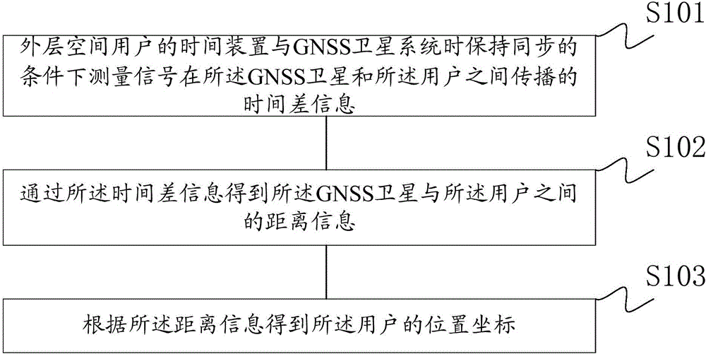
[0046] In order to solve the technical problems such as the low precision of the existing GNSS ultra-long-distance positioning, the embodiment of the present invention provides a method for the earth GNSS satellite to realize user positioning in outer space, such as figure 1 As shown, the method described in this embodiment includes the following steps:

[0047] Step S101: Under the condition that the time device of the user in outer space is synchronized with the time of the GNSS satellite system, the time difference information of the signal propagating between the GNSS satellite and the user is measured; wherein, the time of the GNSS satellite system refers to all the time differences of the GNSS system Satellites are uniformly synchronized and maintained by an atomic time system.

[0048] The method of this embodiment eliminates the clock error unknown quantity in the existing GNSS pseudo-range by synchronously calibrating the system time of the time device and the GNSS sa...


PUM


Abstract

The invention discloses a method for realizing outer space user positioning by earth GNSS satellites. The method includes: measuring time difference information of transmission of a signal between GNSS satellites and a user under the condition that a time device of an outer space user is kept synchronous with GNSS satellite system time; obtaining information of distance between the GNSS satellites and the user through the time difference information; and obtaining position coordinates of the user according to the distance information. The method provided by the invention eliminates time difference of the satellites and the user by using the time device of the user, thereby improving positioning accuracy of the user.

Description

technical field [0001] The invention belongs to the technical field of satellite positioning, and in particular relates to a method for realizing user positioning in outer space by earth GNSS satellites. Background technique [0002] The full name of GNSS (Global Navigation Satellite System) is Global Navigation Satellite System, which refers to all satellite navigation systems, including global, regional and enhanced, such as GPS in the United States, Glonass in Russia, and Galileo in Europe. (Galileo), China's Beidou satellite navigation system, and related augmentation systems. [0003] At present, the GNSS system adopts the pseudo-range positioning system of time-of-arrival measurement. The pseudo-range obtained by measuring the propagation time of the signal transmitted by the GNSS satellite with the clock carried by the user is as follows: [0004] ρ = c · ( t u ...

Claims


Application Information

Patent Timeline
Patent Type & Authority Applications(China)
IPC IPC(8): G01S19/42
CPCG01S19/42
Inventor 孙国良
Owner BEIHANG UNIV
Learn More