Method for quickly calculating fuzzy degree between RTK reference stations in Beidou-compatible GPS/GLONASS network

A technology of ambiguity and reference stations, applied in satellite radio beacon positioning systems, measuring devices, instruments, etc., can solve the problem of weakening correlation of system errors, difficulty in accurately solving the entire ambiguity value, and increasing system error residuals And other issues

Active Publication Date: 2015-12-30
SOUTHEAST UNIV
View PDF2 Cites 14 Cited by
  • Summary
  • Abstract
  • Description
  • Claims
  • Application Information

AI Technical Summary

Problems solved by technology

With the increase of the baseline distance between reference stations, the correlation of systematic errors gradually weakens, and the systematic error residuals in double-difference observations

Method used


Image

  • Method for quickly calculating fuzzy degree between RTK reference stations in Beidou-compatible GPS/GLONASS network
  • Method for quickly calculating fuzzy degree between RTK reference stations in Beidou-compatible GPS/GLONASS network
  • Method for quickly calculating fuzzy degree between RTK reference stations in Beidou-compatible GPS/GLONASS network

Examples


Example Embodiment

[0038] The present invention will be further explained below in conjunction with the drawings.

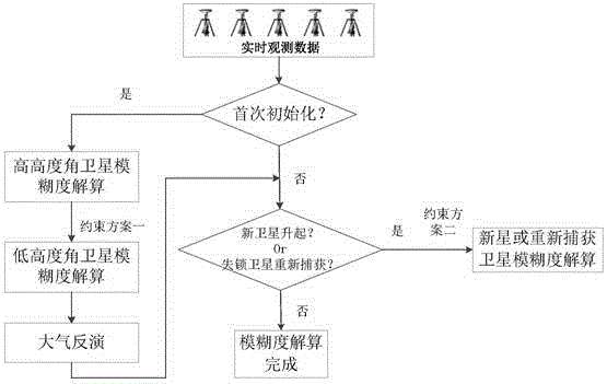
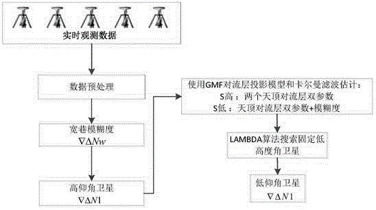
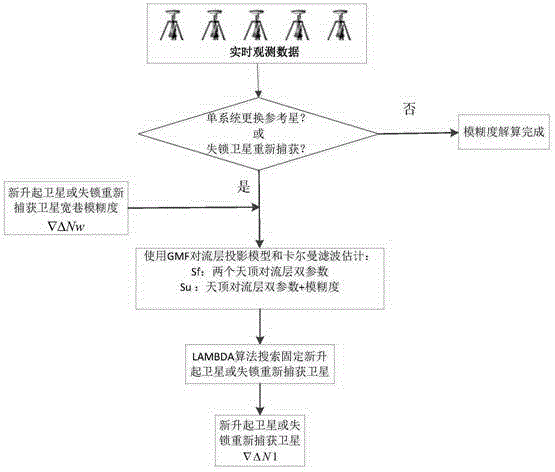
[0039] In the multi-system fusion network RTK, according to the network RTK ambiguity resolution model with the constraint of atmospheric delay prior information, the high altitude satellites are first fixed, and then the satellite observation values ​​with fixed ambiguities are constrained to constrain the atmospheric delay. The corresponding observation equations of low-altitude satellites, newly rising satellites or reacquisitioned satellites are solved simultaneously, and the ambiguity of unfixed ambiguity satellites can be quickly fixed. The general flow chart is as follows figure 1 Shown.

[0040] It includes the following steps:

[0041] 1) The control center performs the first initialization judgment based on the real-time observation data: when the control center is initialized for the first time, the ambiguity of the low-altitude satellite is solved through the constraint plan ...


PUM


Abstract

The invention discloses a method for quickly calculating the fuzzy degree between RTK reference stations in a Beidou-compatible GPS/GLONASS network. In a network RTK model, the calculation accuracy of the fuzzy degree between RTK reference stations has a direct bearing on the precision of space error modeling of the troposphere, the ionosphere, and the like. In the multi-constellation fusion network RTK, the number of satellites increases significantly, which provides favorable conditions for quickly calculating the fuzzy degree. According to the invention, first, a high-altitude angle satellite is fixed according to a network RTK fuzzy degree calculation model with atmospheric delay priori information, and then, calculation is performed based on the observed value constraint atmospheric delay of a satellite of which the fuzzy degree is fixed and an observation equation corresponding to a low-altitude angle satellite or a newly rising satellite or an unlocked recaptured satellite so as to quickly fix the fuzzy degree of a satellite of which the fuzzy degree is not fixed. By adopting the method, the time for calculating the fuzzy degree between network RTK reference stations is obviously shortened, and the precision and reliability of network RTK positioning are improved.

Description

technical field [0001] The invention belongs to the field of network RTK positioning, and in particular relates to ambiguity resolution between Beidou-compatible GPS / GLONASS multi-system network RTK reference stations. Background technique [0002] With the development of global satellite navigation and positioning systems, compatible positioning based on multi-constellation satellite navigation systems has become a research hotspot in the field of navigation and positioning. The Beidou satellite navigation system is a global satellite positioning and communication system (BDS) developed by my country itself, and it is the third mature satellite navigation system after GPS and GLONASS. Compatible positioning between Beidou and GPS / GLONASS is of great significance. Users can use different constellation system combinations for compatible positioning according to actual needs, so as to avoid the problem of too few satellites and over-reliance on this specific constellation when...

Claims


Application Information

Patent Timeline
IPC IPC(8): G01S19/44G01S19/33
Inventor 潘树国王胜利高成发吴波
Owner SOUTHEAST UNIV
Why Eureka
Try Eureka