Quantitative remote sensing method of suspended sediment

A technology of sediment content and sediment, applied in the field of remote sensing, can solve the problem of non-uniformity of the nonlinear relationship of the model

Inactive Publication Date: 2016-02-03
GUANGZHOU INST OF GEOGRAPHY GUANGDONG ACAD OF SCI
View PDF2 Cites 17 Cited by
  • Summary
  • Abstract
  • Description
  • Claims
  • Application Information

AI Technical Summary

Problems solved by technology

[0003] At present, there are many researches on remote sensing of suspended solids that are at the domestic leading level, but most of them are remote sensing monitoring with coarse resolution, and the nonlinear relationship of the model is not unified, and some researches are only qualitative analysis of sediment distribution and flow field; However, there are few reports on the unified study of all estuaries near the coast as a whole.

Method used


Image

  • Quantitative remote sensing method of suspended sediment
  • Quantitative remote sensing method of suspended sediment
  • Quantitative remote sensing method of suspended sediment

Examples


Embodiment

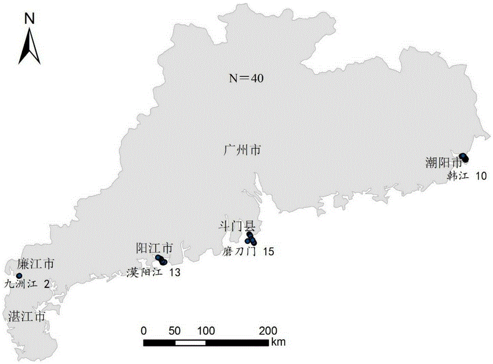
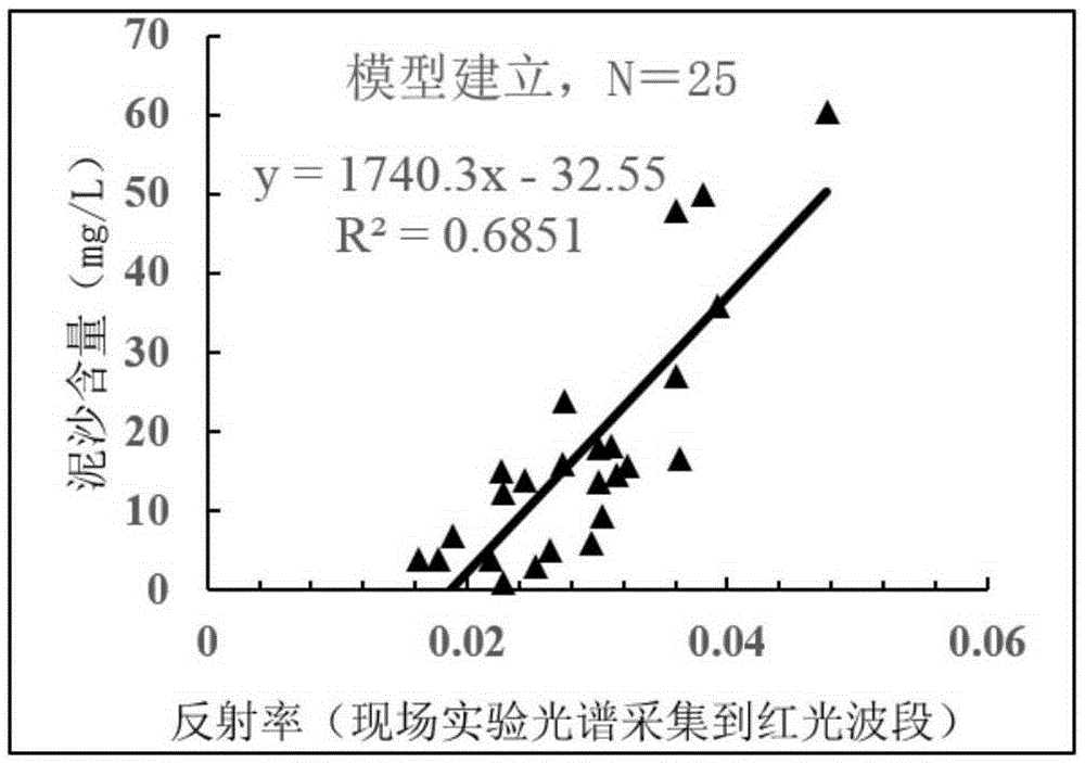
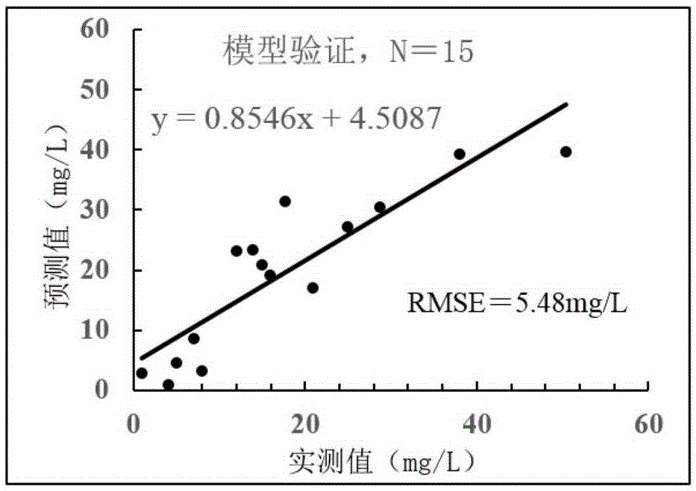
[0035] 1. Study area and characteristics of water and sediment:

[0036] In a preferred embodiment of the present invention, the research area is the main estuary into the sea and its coastal waters in Guangdong Province. It mainly includes the Pearl River: a total length of 2,214 kilometers, a drainage area of ​​453,690 square kilometers, and an annual runoff of more than 330 billion cubic meters, ranking second in the country's river system; Han River: the Han River Basin is located in eastern Guangdong and southwestern Fujian. The second largest river basin in Guangdong Province except the Pearl River Basin, with a drainage area of ​​30,112 square kilometers, the average annual sediment load of the Han River is 6.9322 million tons, and the average annual sediment load modulus is 212.68 tons per square kilometer. The volume is 0.258 kilograms per cubic meter; Modaomen: Modaomen is located in Qirenshi, Hongwan, Zhuhai City, Guangdong Province. It is the main outlet gate of th...


PUM


Abstract

The invention discloses a quantitative remote sensing method of suspended sediment. The quantitative remote sensing method comprises the following steps: step S1, carrying out field water body spectral measurement and suspended sediment content measurement; step S2, carrying out equivalent remote sensing reflectivity calculation; step S3, randomly dividing collected water samples into a modeling sample and a verification sample; step S4, establishing a sediment remote sensing quantitative model by the modeling sample; step S5, acquiring a satellite image and pre-processing the satellite image; and step S6, carrying out inversion to obtain the content of the suspended sediment in a research region. By establishing the sediment remote sensing quantitative model, the sediment remote sensing quantitative model is applied to a satellite remote sensing image through ENVI (The Environment for Visualizing Images) software and spatial and temporal distribution of the sediment in the research region can be automatically drawn; and the method is a scientific and efficient river-mouth off-shore sediment research method.

Description

technical field [0001] The invention relates to the technical field of remote sensing, in particular to quantitative inversion and remote sensing monitoring of suspended sediments in estuaries entering the sea and their coastal waters. Background technique [0002] Suspended sediment is one of the most important water quality parameters in water bodies. Its content and the law of sedimentation movement directly affect the management of estuaries and the safety of flood discharge. The conventional suspended sediment determination method is to collect water samples on site, then filter the water samples, dry and weigh them, and then calculate the concentration. This method is time-consuming, laborious, and difficult to meet the requirements of large-area monitoring. With its macroscopic and large-area monitoring characteristics, remote sensing technology can provide remote sensing images of large-scale water areas at the same time, so it has its unique advantages in water env...

Claims


Application Information

Patent Timeline
Patent Type & Authority Applications(China)
IPC IPC(8): G01N15/06
Inventor 王重洋陈水森姜浩李丹杨骥黄思宇刘尉
Owner GUANGZHOU INST OF GEOGRAPHY GUANGDONG ACAD OF SCI
Why Eureka
Try Eureka