Method for simultaneously realizing panorama remote-vision imaging and boring locus measurement

An implementation method and panoramic image technology, applied in the field of detecting the virtual core of the borehole and measuring the trajectory of the borehole, can solve the problem of no borehole imaging

Inactive Publication Date: 2016-02-17
WUHAN UNIV
View PDF2 Cites 17 Cited by
  • Summary
  • Abstract
  • Description
  • Claims
  • Application Information

AI Technical Summary

Problems solved by technology

[0004] It is known that there is no method for combining borehole imaging technology and borehole trajectory measurement technology in the prior art

Method used


Image

  • Method for simultaneously realizing panorama remote-vision imaging and boring locus measurement
  • Method for simultaneously realizing panorama remote-vision imaging and boring locus measurement
  • Method for simultaneously realizing panorama remote-vision imaging and boring locus measurement

Examples


Embodiment Construction

[0064] The present invention will be further described below in conjunction with the accompanying drawings and embodiments.

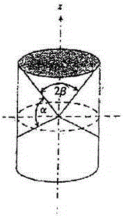
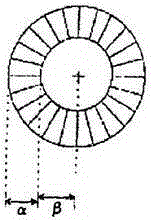
[0065] The main purpose of the present invention is to apply the drilling trajectory measurement technology used in the process of directional well drilling to the process of the drilling imager performing panoramic remote viewing imaging on the drilling wall, so that the two can be carried out simultaneously, that is, the panoramic imaging technology is combined with borehole trajectory measurement technology into the same method. The present invention can compare the intermediate values ​​and results of the coordinate operations involved in the two processes to ensure the accuracy of the obtained coordinate information and the reliability of the obtained panoramic image and drilling trajectory. The equipment has high economy and reliability.

[0066] A method for simultaneously realizing panoramic remote viewing imaging and borehole trajectory measur...


PUM


Abstract

The invention provides a method for simultaneously realizing panorama remote-vision imaging and boring locus measurement. When a bore is actually detected, an elevation and horizontal coordinates in bore position parameters can be measured, including such information as a bore diameter, a bore depth and the like, in particular, some positions which do not accord with a predetermined drilling locus, occurring in detection of actual boring, for instance, a variable diameter position of the bore, positions including a direction deviation of the bore and the like are measured and recorded, accordingly, assistance of correct space coordinate information can be provided for a hole wall panorama picture of each position of the bore, and thus the picture splicing quality and the data reliability are improved; and detailed three-dimensional position coordinates of all exploration points and an accurate probe movement locus graph can be obtained, assistance is provided for work personnel in determining detailed positions of image interest points, and a detailed basis is provided for analyzing various structure constructions and mineral reserve distribution in the bore.

Description

technical field [0001] The invention belongs to the field of engineering detection, in particular to a method for detecting a virtual rock core of a borehole and measuring a trajectory of the borehole. Background technique [0002] Panoramic imaging technology is the basic technology in borehole imaging. At present, all borehole imagers on the market use this technology to perform panoramic imaging of the detected borehole, and generate a three-dimensional virtual core columnar map of the borehole and its planar expansion map. Suitable for fracture zone formations where actual cores are not available. [0003] Borehole trajectory measurement is a common technique for directional well drilling. Due to the influence of factors such as formation anisotropy and the ability of deflection tools, the actual drilling trajectory often cannot advance along the designed trajectory. In order to accurately drill to the target point, it is necessary to keep abreast of the variation of th...

Claims


Application Information

Patent Timeline
Patent Type & Authority Applications(China)
IPC IPC(8): G06T7/00G06T3/40
CPCG06T3/4038G06T7/0004G06T2207/30108
Inventor 关岳周凡
Owner WUHAN UNIV
Why Eureka
Try Eureka