Unmanned aerial vehicle motion target tracking and positioning method under geographic information space-time constraint

A geographic information and moving target technology, applied in the field of UAV moving target tracking and positioning, can solve problems such as difficult to meet real-time positioning, difficult moving target tracking, and inability to obtain high-precision geographic coordinates of the target, so as to achieve high-precision positioning of the target , Improve tracking accuracy and reliability, improve tracking reliability and efficiency

Active Publication Date: 2016-02-24
WUHAN UNIV
View PDF3 Cites 20 Cited by
  • Summary
  • Abstract
  • Description
  • Claims
  • Application Information

AI Technical Summary

Problems solved by technology

[0009] In addition, the existing target tracking methods generally only obtain the pixel coordinates of the target on the video image, and cannot obtain the real high-precision geographic coordinates of the target, which is difficult to meet the needs of tasks such as aerial reconnaissance, target surveillance, and real-

Method used


Image

  • Unmanned aerial vehicle motion target tracking and positioning method under geographic information space-time constraint
  • Unmanned aerial vehicle motion target tracking and positioning method under geographic information space-time constraint
  • Unmanned aerial vehicle motion target tracking and positioning method under geographic information space-time constraint

Examples


Embodiment Construction

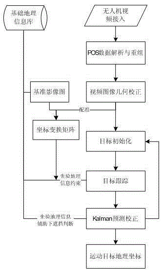
[0036] The technical solutions of the present invention will be described in detail below in conjunction with the drawings and specific embodiments.

[0037] Step 1: Analysis and reorganization of UAV POS (Position and Orientation System, positioning and orientation system) data.

[0038] This step is to obtain the outer azimuth element and the outer azimuth line element of the aerial photo according to the attitude angle and the geometric center position of the IMU in the POS data. The implementation process of this step is a prior art.

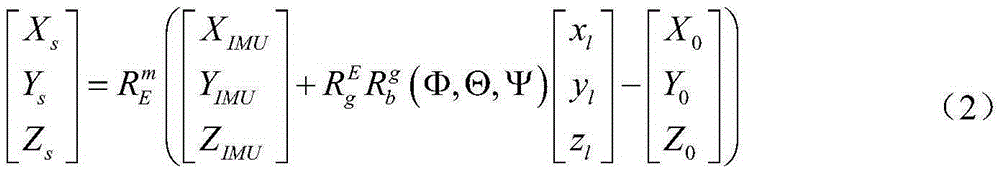
[0039] The inertial measurement unit (IMU) can obtain the attitude angle of the UAV. It usually uses the HPR (heading, pitch, roll) system. The heading, pitch, and roll refer to the yaw angle, pitch angle, and roll angle, respectively. In the field of photogrammetry, the OPK system is generally used to represent the outer azimuth elements of aerial photographs. Therefore, it is necessary to convert the attitude angle (Φ, Θ, Ψ) measured by t...


PUM


Abstract

The present invention discloses an unmanned aerial vehicle (UAV) motion target tracking and positioning method under geographic information space-time constraint. The method comprises the steps of: acquiring angle elements of exterior orientation and line elements of exterior orientation of an aerophotograph according to UAV POS data; conducting geometric correction on the aerophotograph by combination with the altitude data to obtain an orthoimage; conducting accurate rectification on the orthoimage by using a basic image in a basic geographic information database, so as to obtain the mapping relation of the geometric correction coordinate and the geographic coordinate of the orthoimage; selecting a target to be tracked namely an initial target on a first frame of the orthoimage; tracking the target frame by frame on an orthoimage sequence; and splicing the orthoimage sequence and displaying a motion trajectory of the target. The invention increases the precision and reliability of tracking and ensures the stability of target tracking.

Description

technical field [0001] The invention belongs to the technical field of visual tracking and spatial positioning, and in particular relates to a method for tracking and positioning a moving target of an unmanned aerial vehicle under the constraints of time and space of geographical information. Background technique [0002] Object tracking is of great value in science and engineering. Unmanned aerial vehicles (UAVs) have been developed and used unprecedentedly because of their advantages such as high mobility, low cost, and flexible operation. Since UAVs equipped with video sensors have the ability to acquire dynamic information and respond quickly, vision-based UAV target tracking and positioning are of great significance in applications such as aerial reconnaissance, target surveillance, and real-time positioning. [0003] The difficulty of the target tracking algorithm is how to design a robust and stable tracking algorithm to adapt to illumination changes, target occlusio...

Claims


Application Information

Patent Timeline
IPC IPC(8): G01C21/20
CPCG01C21/20
Inventor 眭海刚吕枘蓬涂继辉蔡肖芋
Owner WUHAN UNIV
Why Eureka
Try Eureka