Automatic cloud detection method and system for multi-spectral remote sensing satellite image

A technology of remote sensing satellites and satellite images, applied in the field of surveying and mapping science, can solve problems such as low efficiency

Active Publication Date: 2016-02-24
WUHAN UNIV
View PDF2 Cites 40 Cited by
  • Summary
  • Abstract
  • Description
  • Claims
  • Application Information

AI Technical Summary

Problems solved by technology

The texture feature method mainly uses the difference between the cloud and ground texture features. Generally speaking, the cloud texture details are obviously less than that of the ground, and the texture features are usually calculated by c

Method used


Image

  • Automatic cloud detection method and system for multi-spectral remote sensing satellite image
  • Automatic cloud detection method and system for multi-spectral remote sensing satellite image
  • Automatic cloud detection method and system for multi-spectral remote sensing satellite image

Examples


Embodiment Construction

[0079] The technical solution of the present invention will be described in detail below in conjunction with the embodiments and accompanying drawings.

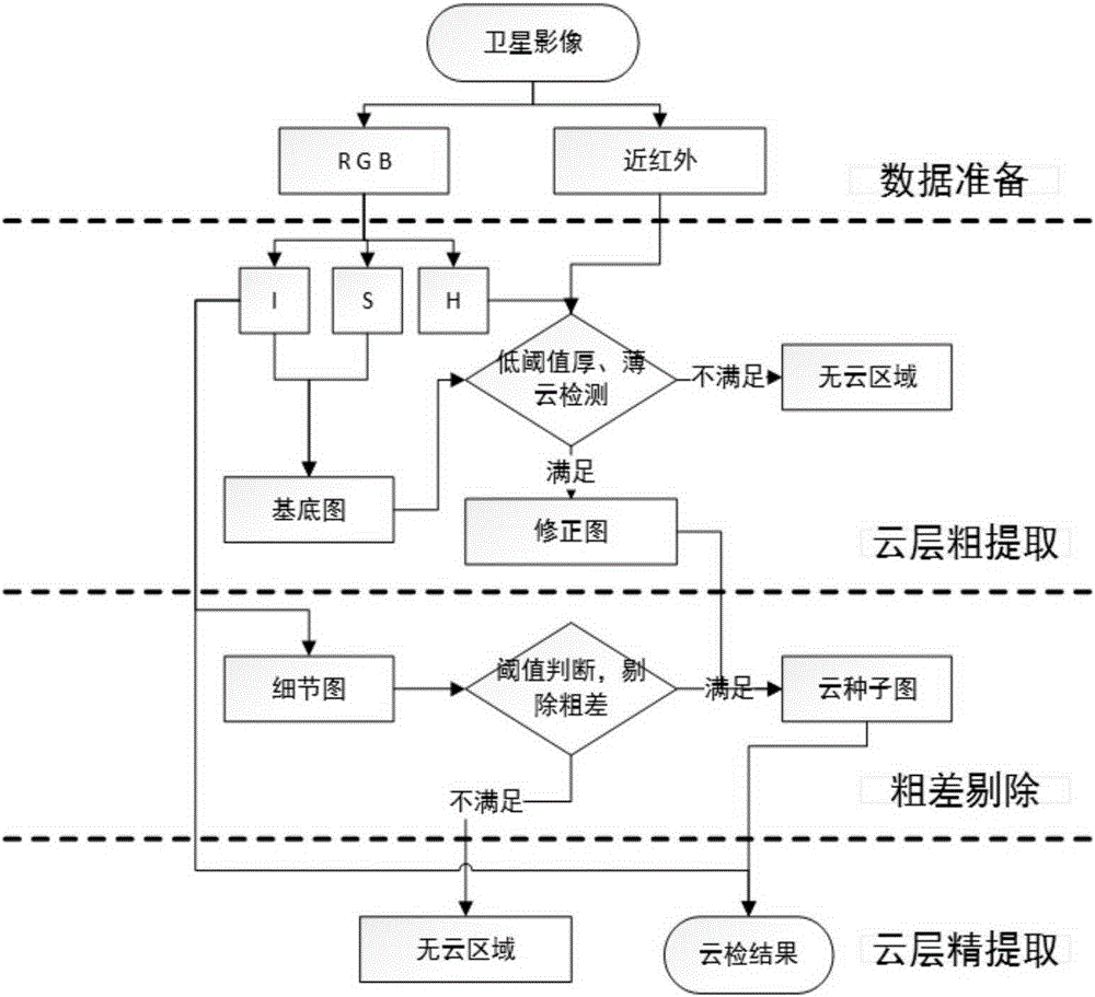
[0080] The present invention provides a fast, accurate and fully automatic automatic cloud detection method for multi-spectral remote sensing satellite images based on threshold segmentation and texture information. It mainly uses the spectrum and texture information of the image for cloud extraction, and firstly uses the spectral information for preliminary detection of cloud results. , and then use the texture information to eliminate the errors in the initial detection results, and finally use the spectral information to accurately detect the cloud layer. The input data are all kinds of high-resolution remote sensing satellite images that can provide data in red, green, blue, and near-infrared bands. see figure 1 The specific implementation method provided by the embodiment includes the following steps:

[0081] Step 1: ...


PUM


Abstract

The present invention provides an automatic cloud detection method and system for a multi-spectral remote sensing satellite image. The method comprises: preparing data; roughly extracting clouds; extracting texture information on an image intensity information channel by combining histogram equalization and bilateral filtering; segmenting a texture information map by using a two-dimensional Otsu threshold; removing an error from a rough detection result by using a binary detail map after segmentation; using intensity information of a raw image as a guide map; and based on the rough detection result with the error being removed, performing accurate extraction on the clouds through edge seed expansion. The technical scheme actually realizes automatic, fast, and accurate detection of cloud.

Description

technical field [0001] The invention belongs to the field of surveying and mapping science and technology, and relates to a multi-spectral remote sensing satellite image automatic cloud detection technology based on threshold value segmentation and texture information. Background technique [0002] During the imaging process of satellite images, due to the influence of the atmosphere, there will be cloud occlusion, which will seriously affect the image quality. Thick clouds cause irreparable damage to ground spectral information. Although thin clouds do not completely cover ground feature information, they still cause spectral distortion of the original ground features, seriously affecting follow-up work such as ground feature interpretation and production of surveying and mapping satellite products. Therefore, realizing accurate cloud detection before production has important practical significance. [0003] At present, it mainly uses the characteristics of cloud spectrum,...

Claims


Application Information

Patent Timeline
IPC IPC(8): G06T7/40
CPCG06T2207/10036G06T2207/30192
Inventor 张永军谭凯童心
Owner WUHAN UNIV
Why Eureka
Try Eureka