Method of extracting sandy coastline by using multiple periods of remote sensing images

A remote sensing image and sand quality technology, applied in the field of space remote sensing, can solve problems such as inaccurate coastlines, achieve the effects of fast extraction process, fully automated operation, and avoid underestimation of coastline positions

Inactive Publication Date: 2016-03-02
THE FIRST INST OF OCEANOGRAPHY SOA
View PDF5 Cites 18 Cited by
  • Summary
  • Abstract
  • Description
  • Claims
  • Application Information

AI Technical Summary

Problems solved by technology

[0006] The invention provides a method for extracting sandy shorelines using multi-phase remote sensing images, which is used to solve the problem of inaccurate coastline extraction from single-scene images in the prior art. Multi-phase remote sensing images are used as the basis for coastline extraction to obtain instantaneous water quality. The position of the sideline is corrected again, and a more accurate sandy coastline can be obtained through the fusion of multi-phase correction water sidelines

Method used


Image

  • Method of extracting sandy coastline by using multiple periods of remote sensing images
  • Method of extracting sandy coastline by using multiple periods of remote sensing images
  • Method of extracting sandy coastline by using multiple periods of remote sensing images

Examples


Embodiment Construction

[0042] In order to make the purpose, technical solutions and advantages of the embodiments of the present invention clearer, the technical solutions in the embodiments of the present invention will be clearly and completely described below in conjunction with the drawings in the embodiments of the present invention. Obviously, the described embodiments It is a part of embodiments of the present invention, but not all embodiments. Based on the embodiments of the present invention, all other embodiments obtained by persons of ordinary skill in the art without creative efforts fall within the protection scope of the present invention.

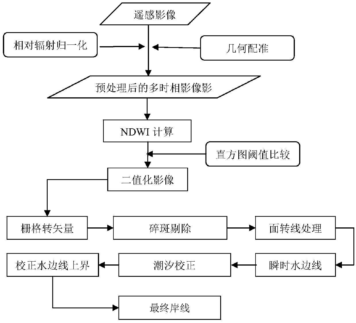
[0043] Such as figure 1 As shown, in this embodiment, a method for extracting sandy shorelines using multi-period remote sensing images is described in detail using multi-period satellite remote sensing images somewhere in the Yellow Sea of ​​China to detect sandy shorelines, including the following steps:

[0044] Step 1: Preprocessing the remot...


PUM


Abstract

The invention discloses a method of extracting a sandy coastline by using multiple periods of remote sensing images. The method comprises the following steps: 1, pretreatment is carried out on remote sensing images acquired via a satellite; 2, an NDWI image is acquired; 3, a binary image with land and water segmentation is acquired; 4, an instantaneous water line is acquired: a raster-vector conversion method is used for converting the binary image into vector data, and through porphyroclast elimination, surface-to-line treatment and false boundary elimination, the instantaneous water line is obtained; 5, tide correction is carried out on the instantaneous water line; and 6, through fusion of multiple periods of corrected water lines, the sandy coastline is acquired. The instantaneous water line is extracted by using the multiple periods of remote sensing images, influences on the coastline position by the tide are also considered, upper lines of multiple water lines through tide correction are fused into an accurate sandy coastline, the coastline extraction process is quick, accurate and fully automatic, and position underestimation of the extracted coastline caused by intertidal zone topografic relief can be effectively avoided.

Description

technical field [0001] The invention relates to a satellite remote sensing coastline detection method, which belongs to the field of space remote sensing technology, in particular to a method for extracting sandy coastlines by using multi-period remote sensing images. Background technique [0002] There are abundant natural resources such as organisms, minerals, energy, and land near the coastline. It is not only an outpost of national defense, but also a link between sea and land transportation, and an area where human economic activities are frequent. Determining the position of the coastline is a necessary technical activity for people to study land-sea interaction, marine geological research, climate change and environmental protection, and it is also an important part of marine topographic mapping and coastal zone surveys. Therefore, rapid and accurate detection of the coastline is of great value. However, due to natural and man-made effects, the actual coastline is in...

Claims


Application Information

Patent Timeline
Patent Type & Authority Applications(China)
IPC IPC(8): G06T7/00
CPCG06T2207/30181
Inventor 孙伟富胡亚斌马毅
Owner THE FIRST INST OF OCEANOGRAPHY SOA
Why Eureka
Try Eureka