Unmanned aerial vehicle hovering precision measurement method based on binocular vision

A technology of hovering precision and binocular vision, which is applied in measuring devices, photogrammetry/video metrology, surveying and navigation, etc. It can solve problems such as the inability to calculate the trajectory of the target and the slow scanning speed of the 3D laser rangefinder.

Active Publication Date: 2016-03-23
STATE GRID INTELLIGENCE TECH CO LTD
View PDF7 Cites 31 Cited by
  • Summary
  • Abstract
  • Description
  • Claims
  • Application Information

AI Technical Summary

Problems solved by technology

Among them, ultrasonic or laser rangefinders are mostly used to measure the distance of the target, while the scanning speed of the 3D laser range

Method used


Image

  • Unmanned aerial vehicle hovering precision measurement method based on binocular vision
  • Unmanned aerial vehicle hovering precision measurement method based on binocular vision
  • Unmanned aerial vehicle hovering precision measurement method based on binocular vision

Examples


Embodiment Construction

[0077] The present invention will be further described below in conjunction with the accompanying drawings and embodiments.

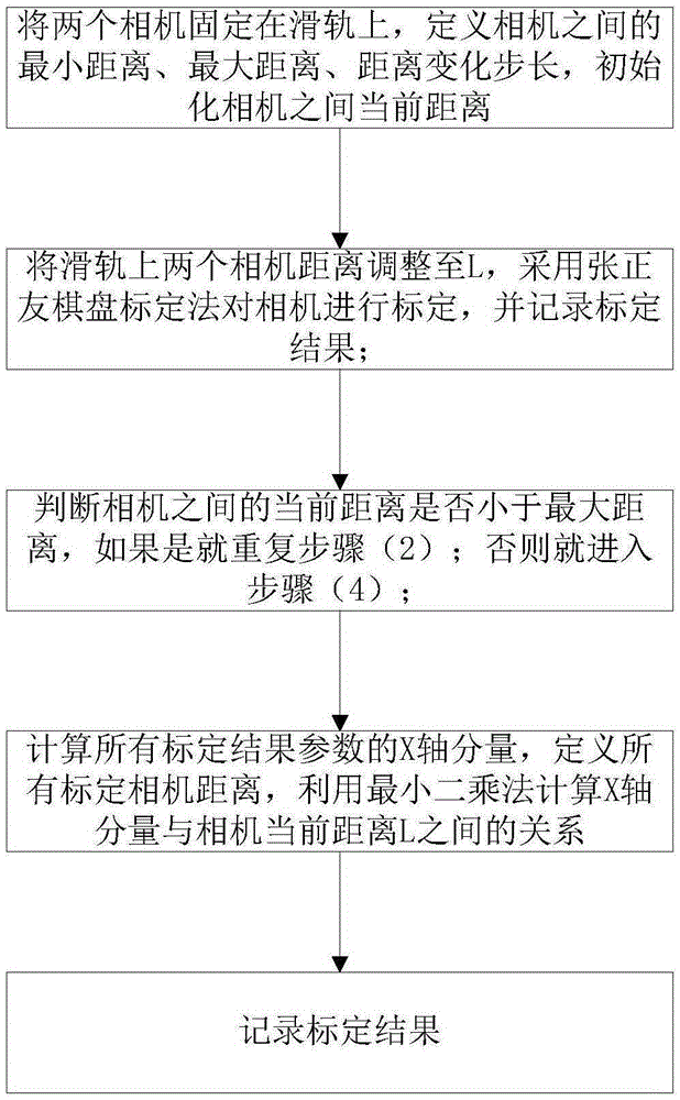
[0078] The hardware consists of: 2 industrial cameras, 1 camera slide rail, 1 set of industrial computer and monitor, and 1 checkerboard calibration version. The whole system structure is as Figure 5 shown.

[0079] 1, 2: Industrial camera. The focal length of the lens is 5mm, the resolution is 1384x1032, and the frame rate is 16 frames per second.

[0080] 3: Camera slide rail. The length is 1.2m, with a scale, and the division value is 1mm.

[0081] 4: Industrial computer and monitor. ADLINK MXC-6000 industrial computer.

[0082] 5: Checkerboard calibration board. The number of squares is 19×17, and the width of each square is 20mm.

[0083] 6: Drones. Unmanned helicopters, multi-rotor drones.

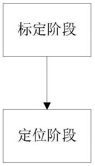
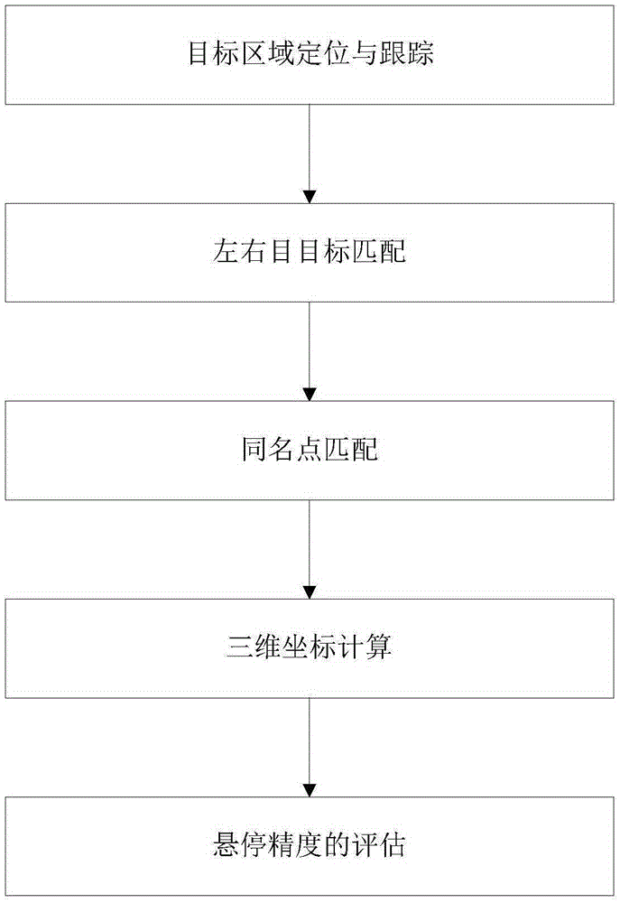
[0084] Such as figure 1 As shown, the whole process is divided into two stages: the calibration stage and the positioning stage. In the calibrati...


PUM


Abstract

The invention discloses an unmanned aerial vehicle hovering precision measurement method based on binocular vision. The method comprises the following steps that in a calibrating stage, a camera is calibrated through a Zhang zhengyou chessboard calibration method to determine a calibration parameter to definite a calibration result parameter; in a positioning stage, when unmanned aerial vehicle hovering precision measurement is performed, a sliding rail is placed under an unmanned aerial vehicle hovering point, the binocular camera is fixed on the sliding rail in parallel according to a set distance and can move in the direction of the sliding rail, camera lenses are vertically and upwards placed, the two camera imaging planes are located at the same plane, and the optical axes of the camera imaging planes are parallel to each other; a left-eye camera body and a right-eye camera body collect unmanned aerial vehicle images and transmit the images to a computer; the computer calculates the three-dimensional position coordinates of an unmanned aerial vehicle according to the left-eye images, the right-eye images and the calibration result parameter; after hovering is finished, the hovering precision is calculated according to the three-dimensional track of the unmanned aerial vehicle. The method has the advantages that target detecting, tracking, precise matching and three-dimensional positioning of the unmanned aerial vehicle are achieved.

Description

technical field [0001] The invention relates to a method for measuring the hovering accuracy of an unmanned aerial vehicle based on binocular vision. Background technique [0002] UAV hovering accuracy is an important indicator of UAV performance, reflecting the core of the UAV - the stability and accuracy of the flight control system. At present, in the inspection and detection process of the flight function of UAVs, the measurement method of hovering accuracy is the method of manual observation, which cannot guarantee its safety, objectivity and standardization. [0003] There are two main ways of UAV three-dimensional space positioning technology: the positioning method based on airborne equipment and the positioning method based on ground equipment. [0004] According to different types of airborne equipment, there are three main positioning technologies based on airborne equipment: Figure 4(a) based on GPS equipment, Figure 4(b) based on airborne video and Figure 4(c) ...

Claims


Application Information

Patent Timeline
IPC IPC(8): G01C11/00G01C11/08
CPCG01C11/00G01C11/08
Inventor 王万国刘俍刘越张方正董罡雍军吴观斌慕世友傅孟潮魏传虎张飞李建祥赵金龙
Owner STATE GRID INTELLIGENCE TECH CO LTD
Why Eureka
Try Eureka