Unmanned plane based geological disaster data collection processing method and device

A technology for data acquisition and processing and geological disasters, applied in image data processing, 3D modeling, instruments, etc., can solve problems such as delaying the best disaster relief time and failing to make corresponding disaster emergency plans in time

Inactive Publication Date: 2016-03-23
武汉地大信息工程股份有限公司
View PDF2 Cites 31 Cited by
  • Summary
  • Abstract
  • Description
  • Claims
  • Application Information

AI Technical Summary

Problems solved by technology

From the acquisition of raw data to the generation of expected products, a large number of software and hardware systems and technical personnel must work together, including data receiving devices, switching devices, storage devices; acquisition systems, processing systems, output systems; image interpretation personnel, GIS data processing personnel , image drawing personnel, etc., in which the data processing system includes professional drawing software (such as PHOTOSHOP), remote sensing image processing software (such as ERDAS / ENVI) and GIS data processing software (such as ARCMAP), so that the response to sudden and urgent geological disasters It is impossible to make a corresponding disaster emergency plan in time, which delays the best time for disaster relief. Therefore, it is urgent to provide a geological disaster data that can automatically collect and process drone images and DEM data, and form a data standardized drawing process. Collection and processing method and device

Method used


Image

  • Unmanned plane based geological disaster data collection processing method and device
  • Unmanned plane based geological disaster data collection processing method and device
  • Unmanned plane based geological disaster data collection processing method and device

Examples


Embodiment Construction

[0026] In order to make the objectives, technical solutions and advantages of the present invention clearer, the present invention will be described in further detail below in conjunction with the accompanying drawings and embodiments. It should be understood that the specific embodiments described here are only used to explain the present invention and are not intended to limit the invention.

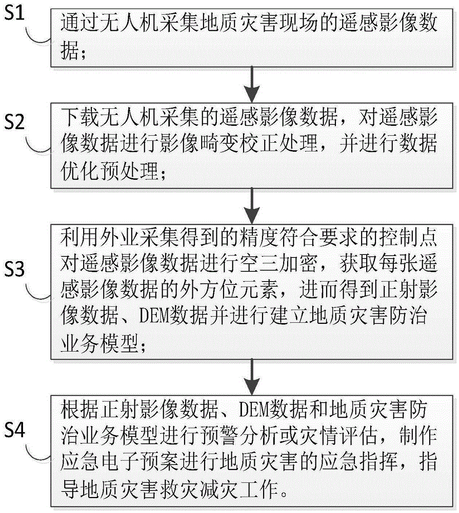
[0027] Such as figure 1 As shown, the embodiment of the present invention provides a method for collecting and processing geological disaster data based on a drone, and the method for collecting and processing geological disaster data based on a drone includes the following steps:

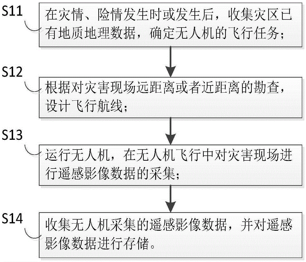
[0028] S1. Collect remote sensing image data of geological disaster sites through drones;

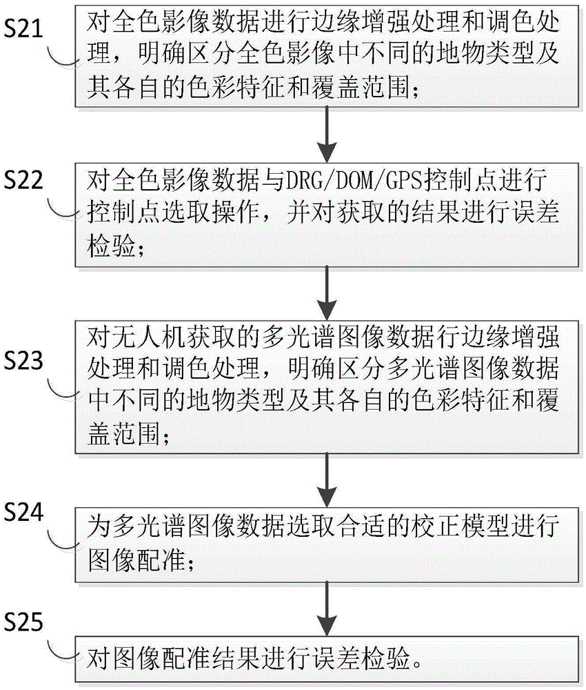
[0029] S2. Download the remote sensing image data collected by the UAV, perform image high-precision distortion correction processing on the remote sensing image data captured by the non-measurement camera mounted o...


PUM


Abstract

The invention provides an unmanned plane based geological disaster data collection processing method and device. High-precision image distortion correction is carried out on remote sensing image data collected by an unmanned plane, and optimizing pre-processing is carried out on the remote sensing image data; control points that satisfy the precision requirement are used to carry out aerial triangulation encryption on the remote sensing image data, exterior orientation elements of each remote sensing image data are obtained, and orthoimage data and DEM data are further obtained, and a geological disaster control service model is established. Image data of the unmanned plane and DEM data are collected automatically in processes, the technical difficulty in processing the image data of the unmanned plane and the DEM data is overcome, a standard data drafting flow is formed, the effectiveness is improved, and the method and device are convenient to popularize and apply; data information obtained by the method and device meets the demand of a geological disaster control service application system, the data input flow in geological disaster investigation and emergency process is thus simplified, and the method and device are timely and efficient.

Description

technical field [0001] The invention relates to the technical field of geological disaster investigation, monitoring, survey design and emergency treatment, in particular to a method and device for collecting and processing geological disaster data based on an unmanned aerial vehicle. Background technique [0002] In recent years, the environmental conditions in geological disaster areas have deteriorated sharply, coupled with the frequent occurrence of local heavy rainfall and various extreme climates, as well as the increasing depth and breadth of human engineering activities (blasting, excavation, stacking, slope cutting, etc.) The possibility and frequency of new geological disasters are increasing, and the situation of prevention and control work is severe and the task is arduous. For a long time, the basic images and DEM data used in geological disaster investigation, monitoring, survey design and emergency response are usually obtained through traditional surveying an...

Claims


Application Information

Patent Timeline
Patent Type & Authority Applications(China)
IPC IPC(8): G06T17/05
CPCG06T17/05
Inventor 马维峰
Owner 武汉地大信息工程股份有限公司
Why Eureka
Try Eureka