Lane level navigation method and system

A navigation method and technology of a navigation system, which are applied to road network navigators, navigation, surveying and mapping, and navigation, etc., can solve the problems of insufficient positioning accuracy, lag in voice prompts, and insufficient map accuracy, and achieve the effect of high positioning accuracy.

Active Publication Date: 2016-05-18
CHINA MERCHANTS CHONGQING COMM RES & DESIGN INST
View PDF11 Cites 54 Cited by
  • Summary
  • Abstract
  • Description
  • Claims
  • Application Information

AI Technical Summary

Problems solved by technology

[0005] In order to solve the problem that the existing lane positioning method is easily affected by external factors such as weather and road markings, the positioning accuracy is insufficient, and the map accuracy is not high enough to cause the voice prompt to lag relatively behind, the present invention proposes a lane-level navigation method and system

Method used


Image

  • Lane level navigation method and system
  • Lane level navigation method and system
  • Lane level navigation method and system

Examples


Embodiment Construction

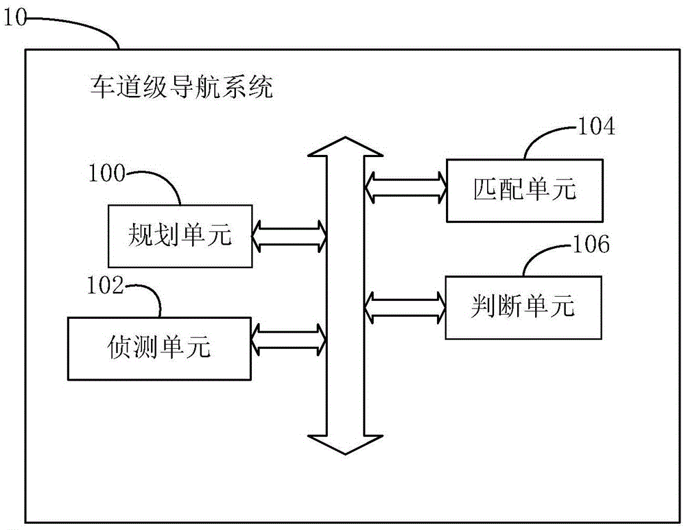
[0047] figure 1 It is a functional block diagram of an embodiment of the lane-level navigation system of the present invention. In the figure, 10 is a lane-level navigation system, 100 is a planning unit, 102 is a detection unit, 104 is a matching unit, and 106 is a judgment unit.

[0048] see figure 1, is a functional block diagram of an embodiment of the lane-level navigation system of the present invention. In this embodiment, the lane-level navigation system 10 performs high-precision positioning on the vehicle and the road section where it is located. The lane-level navigation system 10 includes: a planning unit 100 , a detection unit 102 , a matching unit 104 and a judging unit 106 . The planning unit 100 is used for planning a navigation route for the vehicle according to road information and road condition information. The detection unit 102 is used to monitor in real time whether the distance between the vehicle and the nearest intersection in the driving directio...


PUM


Abstract

Disclosed is a lane level navigation method. High-precision positioning is performed on a vehicle and a road segment where the vehicle is located, and the high-precision positioning accuracy is not lower than the centimeter level. The method comprises the following steps that S20, a navigation path is planned for the vehicle according to road information and road condition information; S21, whether the distance between the vehicle and the nearest road intersection in the driving direction of the navigation path is smaller than or equal to a preset value or not is monitored in real time, if yes, the step S22 is executed; if not, the step S21 is executed continuously; S22, lane matching is performed; S23, whether the vehicle is located on the correct lane or not is judged, and the correct lane is a driving lane planned by a navigation center on the navigation path; if yes, the step S21 is executed again; if not, the step S24 is executed; S24, the path is planned to guide the vehicle into the correct lane, and after the vehicle passes through the road intersection, the step S21 is executed again. The lane level positioning method and system have the advantages that the positioning precision is high, the lane where the vehicle is located can be obtained in real time, the vehicle is planned and guided in real time to enter the correct lane, and the vehicle is not likely to miss the intersection where the vehicle needs to steer.

Description

technical field [0001] The invention relates to the field of Internet of Vehicles, in particular to a lane-level navigation method and system. Background technique [0002] At present, the navigation system is mainly used to provide travelers with route planning before travel and real-time guidance during travel. Some navigation systems can provide static warning information such as real-time road conditions, road speed limit information, and red light capture. The main purpose of the existing navigation system is still to shorten travel time and improve the travel efficiency of travelers, and the safety warning information provided is very limited, and they are all auxiliary functions. However, with the rapid development of the Internet of Vehicles and smart cars, people, cars, and roads are increasingly connected, and travel safety will also become another important factor that needs to be considered by navigation systems. [0003] Due to insufficient positioning accuracy...

Claims


Application Information

Patent Timeline
Patent Type & Authority Applications(China)
IPC IPC(8): G01C21/36
CPCG01C21/3658
Inventor 陈新海谯志王少飞祖晖付建胜李敏张登超
Owner CHINA MERCHANTS CHONGQING COMM RES & DESIGN INST
Why Eureka
Try Eureka