OSG-based visual scene creation method for dynamically programming stereoscopic agriculture in gully district

A three-dimensional agriculture and dynamic planning technology, applied in 3D modeling, 3D image processing, image data processing, etc., can solve the problem of not supporting large-scale crop model human-computer interaction, dynamic cropping function, and unable to provide effective control and dynamic real-time Planning, low-efficiency rendering of large-scale crop models, etc., to avoid loss of materials

Inactive Publication Date: 2016-06-15
INST OF GEOGRAPHICAL SCI & NATURAL RESOURCE RES CAS
View PDF6 Cites 5 Cited by
  • Summary
  • Abstract
  • Description
  • Claims
  • Application Information

AI Technical Summary

Problems solved by technology

However, in the field of agriculture, no one has yet adopted OSG technology for simulation of agricultural planning
[0004] The existing 3D simulation of watershed scenes mainly uses the traditional 3D rendering engine OpenGraphicsLibrary (OpenGL) for rendering. Because it uses a non-object-oriented low-level engine and the method of basic primiti

Method used


Image

  • OSG-based visual scene creation method for dynamically programming stereoscopic agriculture in gully district
  • OSG-based visual scene creation method for dynamically programming stereoscopic agriculture in gully district
  • OSG-based visual scene creation method for dynamically programming stereoscopic agriculture in gully district

Examples


Embodiment 1

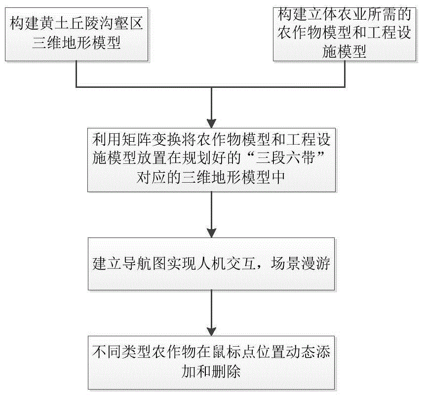
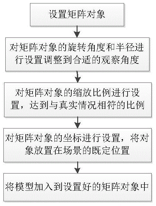
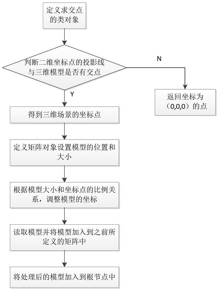
[0033] The technical solution of the present invention will now be described in detail in conjunction with the accompanying drawings. Such as figure 1 As shown, in this embodiment, the scene construction method of the present invention mainly includes the following steps:

[0034] 1. Establish a 3D terrain model of the loess hilly and gully area. Specifically: According to the requirements for the color, direction, and depth of the loess hilly gully area, use the WorldMachine mountain terrain production software to create the scene of the gully area, import the image of the terrain model into 3DSmax as a bitmap and texture in png format, and place it in the scene Add a displacement modifier to the bitmap, set the displacement intensity of the output bitmap to 600, create a material ball, and map the diffuse color, highlight color, highlight level and bump in the scene respectively, using the osgEXP plug-in Export the scene model file in osg format;

[0035] 2. Establish cro...


PUM


Abstract

The invention provides an OSG-based method for establishing a three-dimensional agricultural visualization scene in a gully area, comprising the following steps: constructing a three-dimensional terrain model in a loess hilly gully area, a variety of crop models in a biological shelter belt, and a basic farmland model; The crop model, basic farmland model and water cellar engineering facility model are loaded to the corresponding scene position in the loess hilly gully area; the scene is rendered; the collision detection principle is used to control the dynamic loading of various crop models through the human-computer interaction mechanism, Replace, move and delete for scene updates. The present invention effectively solves the processing efficiency of dynamic scenes of 3990-scale farmland models and multiple different types of crop models, as well as the dynamic cutting and updating of multiple crop models. It provides an auxiliary decision-making method for effective regulation and dynamic planning for experts in the field of land consolidation and utilization.

Description

technical field [0001] The invention belongs to the field of agricultural planning, and in particular relates to an OSG-based method for establishing a visualization scene of three-dimensional agricultural dynamic planning in gully areas. Background technique [0002] The gully area, especially the loess hills, is the area with the most serious soil erosion on the Loess Plateau. Affected by terrain control, vegetation is sparse and soil erosion is serious. How to explore the rural characteristic ecological economic development model in loess hilly and gully areas based on topography and soil erosion laws has practical significance for planning and decision-making in promoting regional ecological construction and poverty alleviation development. Therefore, experts in the field of land consolidation and utilization hope to use virtual reality technology to realize the "three belts and six sections" model that integrates biological (forest, grass, irrigation) measures, engineer...

Claims


Application Information

Patent Timeline
IPC IPC(8): G06T15/00G06T15/50G06T17/05G06T19/20G06Q50/02
CPCG06T15/005G06Q50/02G06T15/50G06T17/05G06T19/20
Inventor 刘彦随张莉谭梁任鑫王介勇李裕瑞
Owner INST OF GEOGRAPHICAL SCI & NATURAL RESOURCE RES CAS
Why Eureka
Try Eureka