DEM data superposition-based marine radar echo simulation method

A technology for nautical radar and echo simulation, applied in radio wave measurement systems, instruments, etc., can solve problems such as loss of elevation information, distortion of echo texture maps, and non-real-time superimposition of radar images, so as to improve simulation accuracy and ensure real-time performance Effect

Active Publication Date: 2016-06-22
ZHENJIANG WATERCRAFT COLLEGE OF PLA
View PDF8 Cites 14 Cited by
  • Summary
  • Abstract
  • Description
  • Claims
  • Application Information

AI Technical Summary

Problems solved by technology

The poor sense of reality of traditional marine radar simulators is mainly reflected in: 1) After replacing the pixel matrix on the scanning line with the echo connected in a band, the radar simulator image generation principle is consistent with the working principle of real radar scanning, but it does not take into account the increasing latitude 2) Using two-dimensional chart shoreline data loses the elevation information of the echo in the real scene, and only using shoreline data cannot reflect the echo on land; 3) Radar image superimposition is not real-time due to the low efficiency of radar image drawing when increasing the resolution of radar echo data or increasing the range

Method used


Image

  • DEM data superposition-based marine radar echo simulation method
  • DEM data superposition-based marine radar echo simulation method
  • DEM data superposition-based marine radar echo simulation method

Examples


Embodiment Construction

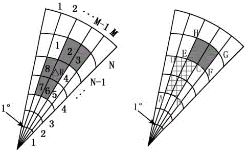
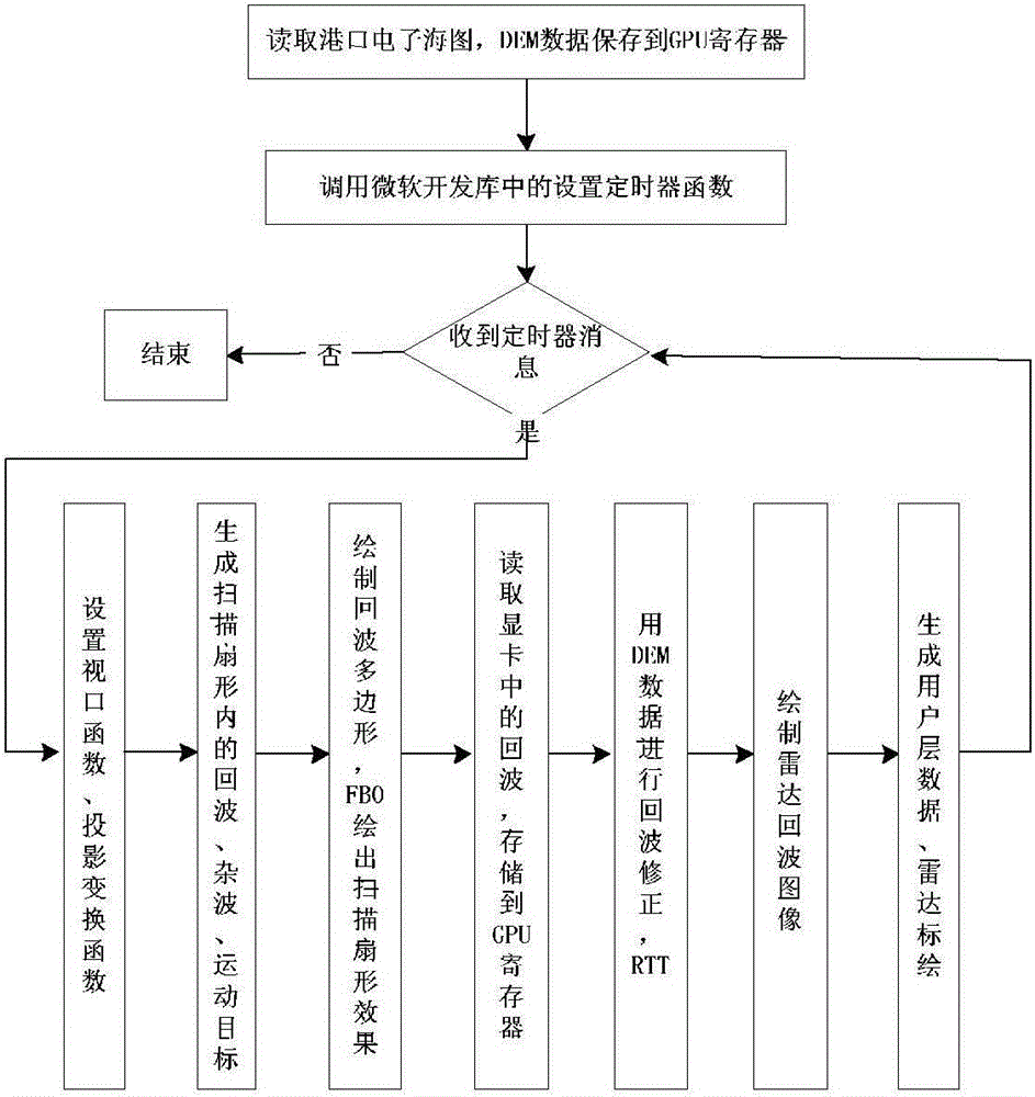
[0029] The present invention is a method for simulating marine radar echoes based on DEM data superposition in an embodiment, comprising the following steps:

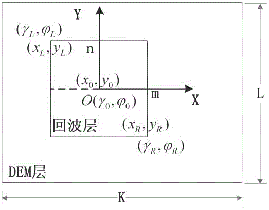
[0030] A. Read the chart data of a certain port, store the DEM data of the area in the GPU texture buffer, store the radar parameters, the latitude and longitude range of the DEM, and the position of the own ship in the radar simulator, and transfer the position information to the GPU constant register. The invention can read the data in the electronic chart and store them as contour data in the form of a linked list. The linked list structure includes: contour elevation, type, sampling points, and contour point data. The DEM data in this area can extract a large amount of surface morphological information. First, use GlobalMapper to open the DEM data and convert it into a bitmap in RGB mode with a depth of 24 bits. Then use matlab to convert the color bitmap into a grayscale image, and use the grayscale value For eleva...


PUM


Abstract

The present invention relates to a marine radar echo simulation system and particularly provides a DEM data superposition-based marine radar echo simulation method. The method comprises the steps of A, reading the electronic sea chart data of a target region, storing a contour in the form of a linked list, storing the position information of a guide control center in a radar simulator, and transferring the information in a GPU constant register at the same time; storing the DEM data of the region in a GPU texture buffer; B, invoking a preset timer function in a Microsoft development library; C, responding to the information of a timer to generate user-layer data, and conducting the radar plotting. According to the technical scheme of the invention, the processing speed of a marine radar simulator is improved. Meanwhile, the simulated radar echo simulation accuracy is improved.

Description

technical field [0001] The invention relates to a navigation radar echo simulation system, in particular to a navigation radar echo simulation method based on DEM (Digital Elevation Model, digital elevation model) data superposition. Background technique [0002] The STCW Convention (The International Convention on Standards of Training, Certification and Watchkeeping for Seafarers, the International Convention on Standards of Training, Certification and Watchkeeping for Seafarers) is one of the most influential conventions on the development of marine simulators. Since 2012, STCW has requested the development of a full-featured simulator for sailing simulators. The poor realism of the target echo is the main problem of the nautical radar simulator. The traditional nautical radar echo simulation is to superimpose the radar image from the two-dimensional electronic chart. Cong Lin et al. (Cong Lin, Ren Hongxiang, Liu Tong, etc. Simulation of Realistic Radar Image in Marine R...

Claims


Application Information

Patent Timeline
Patent Type & Authority Applications(China)
IPC IPC(8): G01S7/40G01S7/41
CPCG01S7/4052G01S7/41
Inventor 程欢王方超卢华平赵柯周滔伍俊周佳虹金乐
Owner ZHENJIANG WATERCRAFT COLLEGE OF PLA
Why Eureka
Try Eureka