Method of realizing satellite remote sensing image high precision geometric correction through slightly modifying RPC parameters

A technology of satellite remote sensing image and geometric correction, applied in image enhancement, image analysis, image data processing and other directions, can solve the problem of model solution uncertainty and so on

Active Publication Date: 2016-07-13
CHINESE ACAD OF SURVEYING & MAPPING
View PDF5 Cites 14 Cited by
  • Summary
  • Abstract
  • Description
  • Claims
  • Application Information

AI Technical Summary

Problems solved by technology

Although the regularization theory has been developed and applied for nearly 40 years, the choice of a reasonable regularization parameter α and a stable functional Ω(Z) has always been a difficulty in the theory and method, and has not been widely recognized so far. The current optimal method for different practical problems brings uncertainty to the solution of the model

Method used


Image

  • Method of realizing satellite remote sensing image high precision geometric correction through slightly modifying RPC parameters
  • Method of realizing satellite remote sensing image high precision geometric correction through slightly modifying RPC parameters
  • Method of realizing satellite remote sensing image high precision geometric correction through slightly modifying RPC parameters

Examples


Embodiment Construction

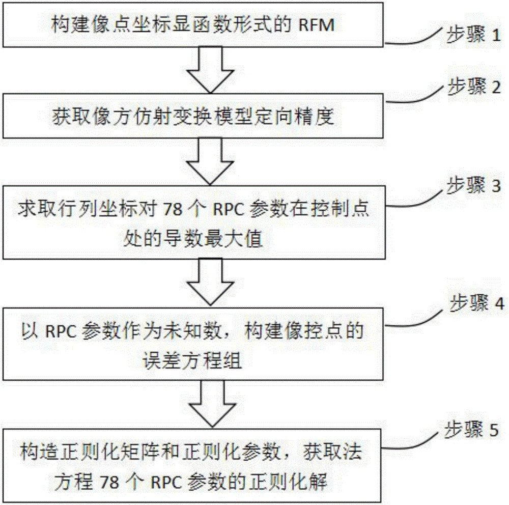
[0081] A method for realizing high-precision geometric correction of satellite remote sensing images by slightly correcting RPC parameters. This method adjusts 78 RPC parameters of RFM after the orientation of traditional RFM image-space affine transformation parameters, and uses image-space affine transformation to orient The precision information adaptively constructs the regularization matrix and regularization parameters, and realizes the refinement of 78 parameters of the satellite remote sensing image RPC parameters. like figure 1 Shown, the present invention is realized through the following steps:

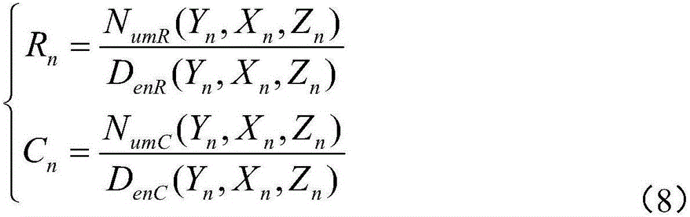
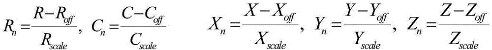
[0082] Step 1. Based on the RFM model, set up the image point row and column coordinates R, the RFM equation of the C explicit function form, and its form is:

[0083] R = R s c a l ...


PUM


Abstract

Provided is a method of realizing satellite remote sensing image high precision geometric correction through slightly modifying RPC parameters, which realizes image high precision geometric correction through adjusting 78 rational polynomial coefficients in RPC parameters of an RPC model after traditional RPC image space affine transformation parameter orientation, wherein a normal equation ill-conditioned problem utilizes precision information after image space affine transformation orientation to adaptively construct a regularizer and regularization parameters, thereby realizing robust resolution of 78 RPC parameters of satellite remote sensing images. Under the condition of sufficient ground control points, the method can obtain higher geometric correction precision than a traditional image space affine transformation RFM recursive model and a precise model, and has obvious advantages than traditional methods in the remote sensing image automatic matching and correction filed based on existing reference geographic data.

Description

technical field [0001] The invention relates to the technical field of geometric processing technology of satellite remote sensing images and the solution of ill-conditioned equations, in particular to a method for realizing high-precision geometric correction of satellite remote sensing images by slightly correcting RPC parameters. Background technique [0002] The form of the rational polynomial model RFM of the general processing model of satellite remote sensing images is as follows: [0003] R n = N u m R ( Y n ...

Claims


Application Information

Patent Timeline
Patent Type & Authority Applications(China)
IPC IPC(8): G06T5/00G06F17/12G06F17/16
CPCG06F17/12G06F17/16G06T5/006G06T2207/10032
Inventor 程春泉黄国满张力赵争张继贤
Owner CHINESE ACAD OF SURVEYING & MAPPING
Why Eureka
Try Eureka