New deformation monitoring method for super high-rise building with troposphere delay influence taken into account

A tropospheric delay and ultra-high-level technology, applied in the direction of electric/magnetic solid deformation measurement, measurement devices, electromagnetic measurement devices, etc., can solve the problem of not considering the correlation between horizontal component parameters and RZTD, difficult to realize adaptive RZTD parameter estimation, and unable to improve RZTD estimation accuracy and other issues, to achieve strong operability and flexibility, improve deformation monitoring accuracy, and improve the effect of monitoring accuracy

Active Publication Date: 2018-11-30
CHANGAN UNIV
View PDF4 Cites 4 Cited by
  • Summary
  • Abstract
  • Description
  • Claims
  • Application Information

AI Technical Summary

Problems solved by technology

[0004] Li Bofeng used a regularization method in "Geometry-specified troposphere decorrelation for subcentimeter real-time kinematic solutions over long baselines [J], Journal of Geophysical Research, 2010, 115, B11404" to better solve the problem of RZTD in LS parameter estimation. Strongly related to elevation, this method can achieve high-precision long-baseline RZTD estimation accuracy through a complex regularization matrix construction method. Although the effect is good, it is more complicated, and it cannot perform multi-epoch cumulative observations to further improve RZTD estimation precision
[0005] Yong W A normalized the RZTD and elevation parameters in "Estimation of troposphere decoration using the combinedzenith-dependent parameter.Proceedings of Ion GNSS, 2008", and achieved the purpose of separating the two by calculating the correlation coefficient between them, but This method does not take into account the correlation between the horizontal component parameters and RZTD, although the correlation is not very obvious relative to the elevation direction
[0006] Kim Don used a spatiotemporal correlation-based forgetting adjustment factor to adjust The main purpose of the RZTD weight of the current epoch and the previous epoch is that the traditional random walk model in the EKF parameter estimation is difficult to adapt to the RZTD sudden change caused by the sudden weather change, but the forgetting factor of this method is also given a priori, which is difficult to achieve True Adaptive RZTD Parameter Estimation

Method used


Image

  • New deformation monitoring method for super high-rise building with troposphere delay influence taken into account
  • New deformation monitoring method for super high-rise building with troposphere delay influence taken into account
  • New deformation monitoring method for super high-rise building with troposphere delay influence taken into account

Examples


Embodiment Construction

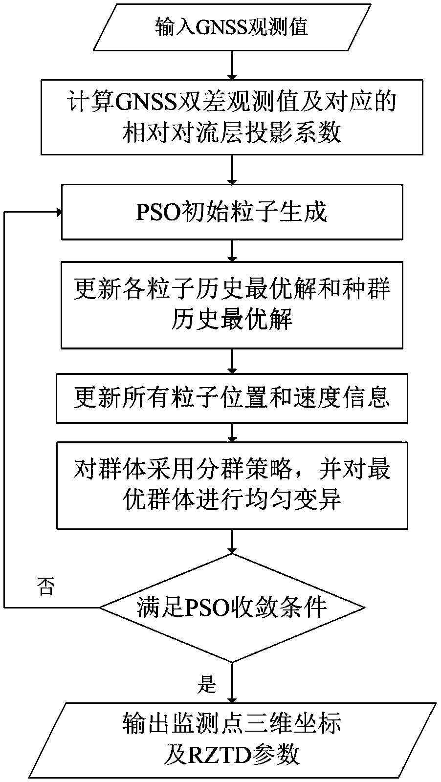
[0051] The present invention will be further described below in conjunction with the accompanying drawings.

[0052] refer to figure 1 , the specific implementation steps of the present invention are as follows:

[0053] Step 1. Calculate the GNSS double difference observation value DD obs , and the relative tropospheric projection coefficient R f .

[0054] DD obs and R f The specific expression is:

[0055]

[0056] R f =f T (θ j )-f T (θ k )

[0057] in is the GNSS carrier observation value, the subscript r and b represent the monitoring station and the base station respectively, the superscript k and j represent the reference star station and the non-reference star respectively, θ j and θ k is the average elevation angle of the satellite (j,k) relative to the two stations, f T is the tropospheric projection function, such as the common NiellMappingFunction (NMF) model.

[0058] Step 2. Construct a four-dimensional search space based on the three-dimensi...


PUM


Abstract

The invention discloses a new GNSS dynamic deformation monitoring method suitable for a super high-rise building. The implementation process comprises the steps that GNSS double difference observed values and corresponding relative troposphere projection coefficients are calculated; a four-dimensional searching space based on monitoring station three-dimensional coordinate X/Y/Z and intersite Relative Zenith Tropospheric Delay (RZTD) is constructed, corresponding Particle Swarm Optimazation (PSO) initiating particles are generated; all particle fitness is calculated based on modified ambiguityfunction method (MAFM); all particle history optimal solution and population history optimal solution are updated; speed and position information of all particles are updated according to all particle history optimal solution and the population history optimal solution; a grouping strategy is adopted for all populations according to the size of fitness, uniform mutation is carried out on an optimal population; if PSO algorithm iteration convergence condition is met, monitoring point three-dimensional coordinates corresponding to optimal particles and RZTD parameter are output, if not, PSO iteration is repeated. The new GNSS dynamic deformation monitoring method suitable for the super high-rise building has high operability and flexibility, high calculation efficiency, and can better weaken troposphere delay error influence caused by a big height difference.

Description

technical field [0001] The invention belongs to the field of GNSS high-precision positioning and application, and relates to GNSS positioning algorithm and super high-rise building deformation monitoring technology. High-precision deformation monitoring of urban super high-rise buildings affected by tropospheric errors. Background technique [0002] Super high-rise buildings are an important symbol of modern urban construction, and deformation monitoring is required during construction and after completion. Global satellite navigation system (GNSS) can be used as an ideal super high-rise building deformation monitoring system due to its advantages of all-weather, simple operation, and high precision. means of monitoring. GNSS super high-rise monitoring generally adopts the relative positioning operation mode. Although the distance between the base station and the monitoring station is relatively close, due to the large height difference, the meteorological difference betwee...

Claims


Application Information

Patent Timeline
Patent Type & Authority Applications(China)
IPC IPC(8): G01B7/16G01S19/42
CPCG01B7/16G01S19/42
Inventor 李昕黄观文赵卫锋刘宁
Owner CHANGAN UNIV
Why Eureka
Try Eureka