Urban intersection lane-level structure extraction method based on time-space trajectory big data

A technology of space-time trajectory and extraction method, which is applied in the traffic control system of road vehicles, traffic flow detection, traffic control system, etc., can solve the problem of plane structure recognition, without further exploration of lane-level road network and intersection plane structure space fusion, etc. problems, to achieve the effect of easy implementation, simple detection method and cost reduction

Active Publication Date: 2016-07-20
WUHAN UNIV
View PDF3 Cites 38 Cited by
  • Summary
  • Abstract
  • Description
  • Claims
  • Application Information

AI Technical Summary

Problems solved by technology

However, the above studies did not conduct an in-depth analysis and identification of the planar structure in the local area of ​​the inte

Method used


Image

  • Urban intersection lane-level structure extraction method based on time-space trajectory big data
  • Urban intersection lane-level structure extraction method based on time-space trajectory big data
  • Urban intersection lane-level structure extraction method based on time-space trajectory big data

Examples


Embodiment Construction

[0033] The technical solutions of the present invention will be described in detail below in conjunction with embodiments and drawings.

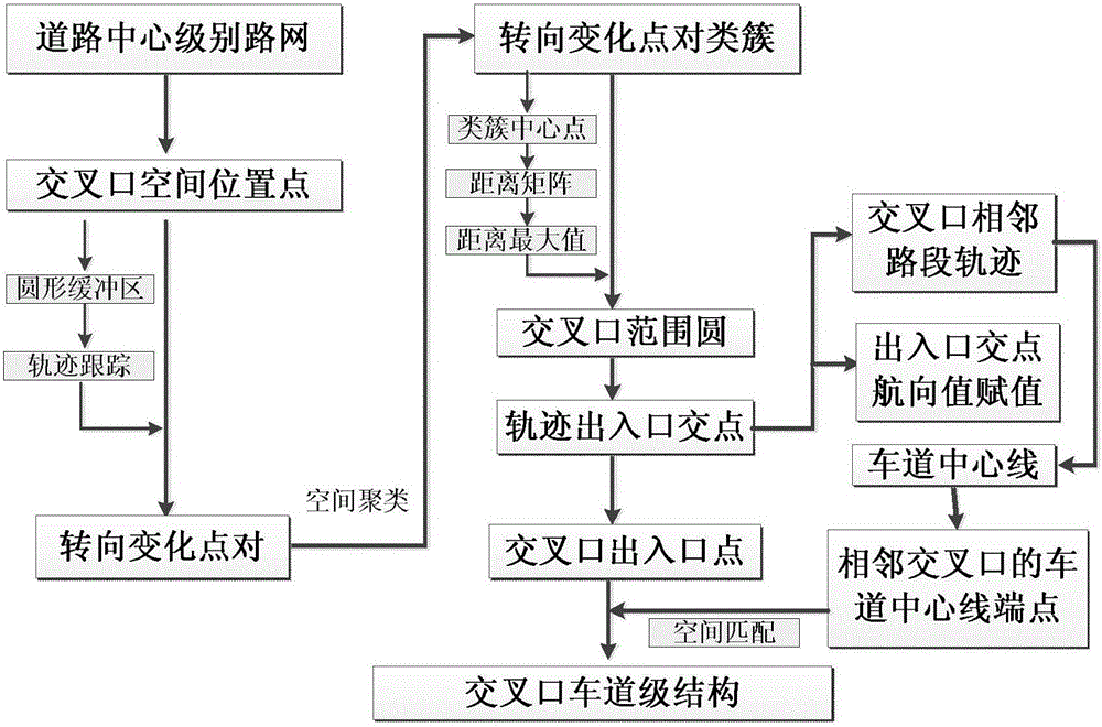
[0034] The technical scheme of the present invention can use computer software to support the automatic operation process. See figure 1 An embodiment of the present invention provides a method for extracting lane-level structure at an urban intersection based on spatio-temporal trajectory data, including the following steps:

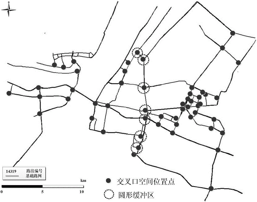
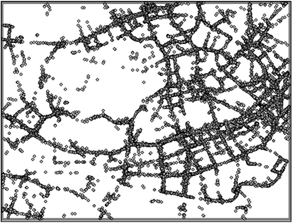
[0035] 1)According to the existing road center-level road network map, obtain the urban intersection spatial location points, and draw a circular buffer with a radius of 50 meters with each intersection spatial location point as the center point; then enter 2) Use trajectory tracking method , Calculate the heading angle change of each trajectory in the circular buffer, extract the trajectory points whose heading angle change value is greater than 45 degrees, and mark them as steering change points; then enter 3) Use density...


PUM


Abstract

The invention provides an urban intersection lane-level structure extraction method based on time-space trajectory big data, which reduces the cost for obtaining urban intersection structure, has simple detection method and is easy to realize. The method comprises following steps: first, obtaining position points of urban intersections according to an existing road axis-level road network graph, and then setting up a circular buffer area; extracting trajectory points whose course angle variation exceeds 45 degrees in trajectory data as turning changing points by means of a trajectory tracking method; secondary, performing clustering to the turning changing points by means of a density clustering method, and establishing an intersection range circle by extracting cluster centers and the spatial distance among them; finally, calculating the intersection points of the trajectory passing through the intersection range circle by means of the trajectory tracking method again, extracting turning entrance points and exit points of the intersection, and matching the turning entrance points and exit points of the intersection with lane axis of adjacent roads by means of spatial matching method to complete the extraction of urban intersection lane-level structure. The accuracy of intersection entrance point and exit point plane structure graph obtained by means of the method is 94.3%.

Description

Technical field [0001] The invention relates to an urban intersection lane-level structure extraction method based on time-space trajectory big data, and belongs to the field of geographic information system and intelligent transportation research. Background technique [0002] Urban road network information is the basis of intelligent transportation related applications. According to the fineness of the urban road network information, the urban road network can be divided into: road centerline network, roadway level network, and lane level network. Among them, the arcs of the road sections and the nodes that express the topological points of the road network are composed of the road network. important parts of. At present, the data sources for obtaining urban road network information include: high-resolution remote sensing images, spatio-temporal trajectory data, laser point cloud data, etc. With the continuous popularization of GPS devices, spatiotemporal trajectory data has b...

Claims


Application Information

Patent Timeline
IPC IPC(8): G08G1/01
CPCG08G1/0125G08G1/0137
Inventor 唐炉亮杨雪牛乐李清泉
Owner WUHAN UNIV
Why Eureka
Try Eureka