
GIS (geographic information system)-based mobile law enforcement system

A technology of mobile law enforcement and law enforcement personnel, applied in the service application field of urban management law enforcement, can solve the problems of reducing the level and efficiency of law enforcement personnel in handling cases, and the office system cannot meet the requirements, and achieve the effect of improving command ability

Inactive Publication Date: 2016-07-27
JIANGSU R & D CENTER FOR INTERNET OF THINGS
View PDF4 Cites 4 Cited by
  • Summary
  • Abstract
  • Description
  • Claims
  • Application Information

AI Technical Summary

Problems solved by technology

[0002] Due to the mobility, suddenness, and urgency of the work of law enforcement agencies, when the majority of law enforcement officers perform various illegal acts while on the move, they cannot timely use the law enforcement information within the department to assist in solving cases and performing official duties, which reduces the quality of law enforcement. Case-handling level and efficiency of personnel
At the same time, law enforcement officers need to collect evidence, check, and record logs on the spot to achieve the purposes of duty, public security, traffic control, and criminal investigation. It is transmitted to the command platform for processing, and GIS refers to the GeographicInformationSystem geographic information system

Method used


Image

  • GIS (geographic information system)-based mobile law enforcement system
  • GIS (geographic information system)-based mobile law enforcement system
  • GIS (geographic information system)-based mobile law enforcement system

Examples


Embodiment Construction

[0022] The present invention will be further described below in conjunction with the accompanying drawings.

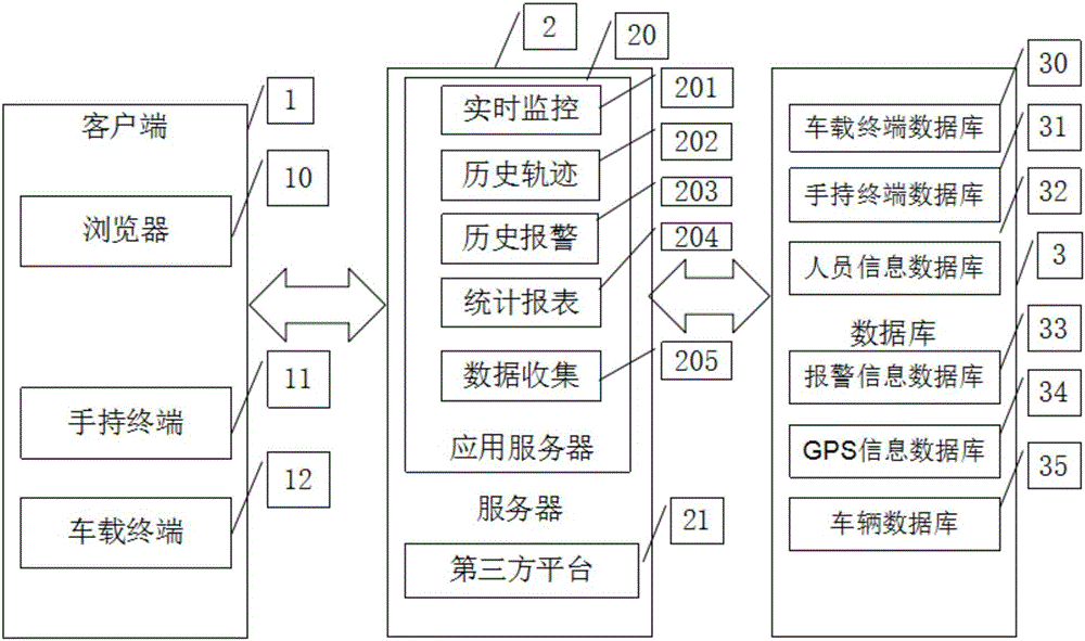
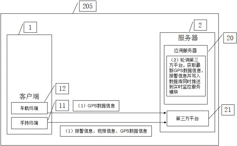
[0023] Such as figure 1 As shown, a GIS-based mobile law enforcement system mainly includes a client 1, a server 2 and a database 3, wherein the client 1 includes a browser 10, a handheld terminal 11 and a vehicle terminal 12, and the browser 10 is used as the mobile law enforcement system. The display platform of the system, the handheld terminal 11 and the vehicle-mounted terminal 12 can regularly send GPS data information to the third-party platform 21; law enforcement officers send alarm information to the third-party platform 21 through the handheld terminal 11 after discovering the police situation; the server 2 includes the application server 20 And the third-party platform 21, the third-party platform 21 is mainly responsible for communicating with the handheld terminal 11 and the vehicle-mounted terminal 12, and the third-party platform 21 can receive and save...


PUM


Abstract

The invention relates to a GIS (geographic information system)-based mobile law enforcement system. According to the GIS-based mobile law enforcement system, a browser is adopted as a display platform; a data collection service module provides positioning parameters for a real-time monitoring service module; a historical track service module displays the historical driving tracks of vehicles or people on a digital map according to historical GPS data information; a historical alarm service module can query historical alarm information; and a statistical report service module carries out statistical calculation on alarm information in a time range selected by a user according to the time range and displays the alarm information in a graphical mode. With the GIS-based mobile law enforcement system of the invention adopted, the positions and driving routes of law enforcement vehicles and law enforcement officers can be monitored in real time; monitoring pictures around the law enforcement vehicles and law enforcement officers can be checked in real time; and therefore, first-hand video data can be provided for urban management law enforcement and assisting a public security organization to handle emergency situations, and law enforcement efficiency can be improved, and the phenomena that law enforcement officers take illegal means in a law enforcement process can be decreased, and disputes caused by the lack of video data evidences can be also decreased.

Description

technical field [0001] The invention relates to a GIS-based mobile law enforcement system, which is used for the service application of urban management law enforcement. Background technique [0002] Due to the mobility, suddenness, and urgency of the work of law enforcement agencies, when the majority of law enforcement officers perform various illegal acts while on the move, they cannot timely use the law enforcement information within the department to assist in solving cases and performing official duties, which reduces the quality of law enforcement. The level and efficiency of personnel handling cases. At the same time, law enforcement officers need to collect evidence, check, and record logs on the spot to achieve the purposes of duty, public security, traffic control, and criminal investigation. It is transmitted to the command platform for processing. GIS refers to the Geographic Information System geographic information system. Contents of the invention [0003...

Claims


Application Information

Patent Timeline
Patent Type & Authority Applications(China)
IPC IPC(8): G06Q50/26G06F17/30G08B25/00
CPCG06Q50/26G06F16/29G08B25/00
Inventor 舒茂军马玉峰台宪青
Owner JIANGSU R & D CENTER FOR INTERNET OF THINGS
Learn More