Farmland consolidation plan intelligent design method supported by GeoDesign

A design method and agricultural land technology, applied in calculation, 3D modeling, geometric CAD, etc., to achieve the effect of improving land utilization, reliable technical support, and improving utilization

Active Publication Date: 2016-08-03
江苏金沙地理信息股份有限公司
View PDF3 Cites 8 Cited by
  • Summary
  • Abstract
  • Description
  • Claims
  • Application Information

AI Technical Summary

Problems solved by technology

In recent years, geographical design has gradually become a research hotspot in the fields of urban and rural planning, digital city, landscape architecture and architectural design, but the research on applying the idea of ​​geographical design to the intelligent design and analysis method of agricultural land consolidation planning is relatively rare.

Method used


Image

  • Farmland consolidation plan intelligent design method supported by GeoDesign
  • Farmland consolidation plan intelligent design method supported by GeoDesign
  • Farmland consolidation plan intelligent design method supported by GeoDesign

Examples


Embodiment Construction

[0021] The present invention will be described in detail below with reference to the drawings and specific embodiments.

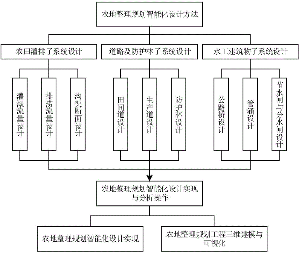
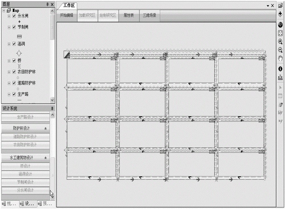
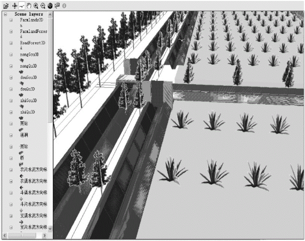
[0022] The present invention takes geographical design as the guiding ideology, comprehensively uses technologies such as GIS, data mining and knowledge discovery, and extracts and expresses geographical abstraction and related knowledge rules for farmland consolidation projects, and completes the farmland irrigation and drainage subsystem, water drainage subsystem, and irrigation system in farmland consolidation planning. Parametric setting of industrial building subsystems, roads and shelterbelt subsystems, and explore the unified organization and management methods of spatial relations, orientation information, attribute information, design parameters, knowledge rules, etc. of agricultural land consolidation engineering geographical objects to realize farmland consolidation planning Intelligent design; on this basis, the comprehensive use of GIS spatial q...


PUM


Abstract

The invention provides a farmland consolidation plan intelligent design method supported by GeoDesign. GIS, data mining, knowledge discovery and other technologies are comprehensively applied based on a geographic design idea, to carry out geography abstraction and extraction and representation of relevant knowledge rules on farmland consolidation engineering, thus completing parameterization setting of a farmland irrigation subsystem, a hydraulic construction subsystem and a road and protection forest subsystem in a farmland consolidation plan; furthermore, a uniform organization and management method for geographic object space relation, orientation information, attribute information, design parameter and knowledge rules of the farmland consolidation engineering is explored, so that intelligent design of a farmland consolidation plan is realized; on the basis of the intelligent design, GIS space inquiry, space analysis and three-dimensional modeling technologies are comprehensively used, so that three-dimensional modeling, three-dimensional visual analysis and other operations of the farmland consolidation planning engineering are realized. According to the method, the efficiency of the farmland consolidation planning and design can be effectively improved, and a technical support and a decision basis can be provided for efficient utilization of farmland resources, farmland informatization management and precise agriculture.

Description

technical field [0001] The invention relates to an intelligent design method for agricultural land arrangement and planning supported by GeoDesign, and the technical application field is agricultural land arrangement and planning. Background technique [0002] Land consolidation is of great significance to increasing cultivated land area, improving land quality, improving agricultural production conditions and ecological environment, and has a certain impact on farmland irrigation and drainage, surface hydrological structure, irrigation water quality, and regional water resource allocation. Using geographic information technology, planning and design, hydraulic engineering and geographic design and other theories and methods to organize land resources and rationally plan and design farmland irrigation and drainage can improve farmland quality and increase agricultural productivity. [0003] In recent years, modern spatial information technologies such as GIS, GPS, photogramm...

Claims


Application Information

Patent Timeline
Patent Type & Authority Applications(China)
IPC IPC(8): G06F17/50G06T17/05G06T19/20
CPCG06F30/13G06T17/05G06T19/20
Inventor 王永志王慧李冬森廖丽霞
Owner 江苏金沙地理信息股份有限公司
Why Eureka
Try Eureka