A security monitoring method for general aviation aircraft and unmanned aerial vehicles

A general aviation and safety monitoring technology, applied in the field of satellite navigation, can solve the problems of single flight safety supervision method and weak strength, and achieve the effect of wide application, ensuring accuracy and update rate

Active Publication Date: 2019-03-22
NO 54 INST OF CHINA ELECTRONICS SCI & TECH GRP
View PDF9 Cites 0 Cited by
  • Summary
  • Abstract
  • Description
  • Claims
  • Application Information

AI Technical Summary

Problems solved by technology

[0004] The purpose of the present invention is to provide a method for real-time status monitoring and control of general aviation aircraft and unmanned aerial vehicles with high reliability, low equipment complexity, and easy deployment, so as to solve the single and weak power of domestic low-altitude airspace flight safety supervision means The problem

Method used


Image

  • A security monitoring method for general aviation aircraft and unmanned aerial vehicles
  • A security monitoring method for general aviation aircraft and unmanned aerial vehicles
  • A security monitoring method for general aviation aircraft and unmanned aerial vehicles

Examples


Embodiment Construction

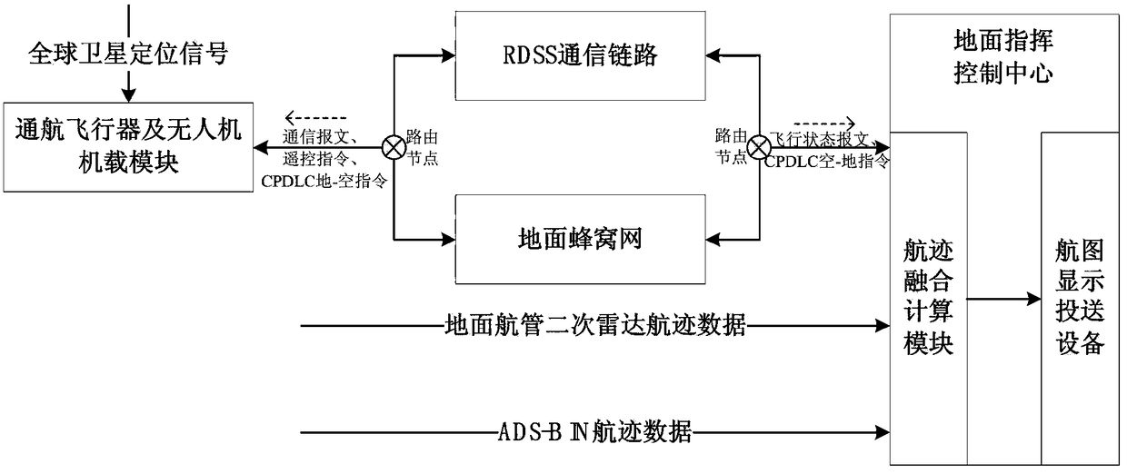
[0033] Taking the ground command and control center as an example to set an electronic fence for a no-fly zone and prohibit aircraft from entering and overflying as an example, the present invention will be further described in conjunction with the accompanying drawings.

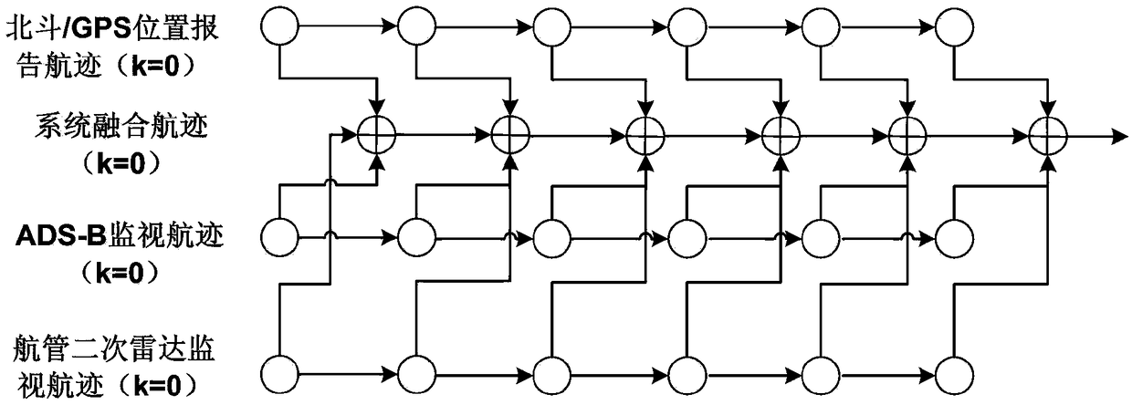
[0034] The basic principles of the safety monitoring technology of the general aviation aircraft of the present invention are as follows: figure 1 as shown,

[0035] (1) Passive positioning of general aviation aircraft and unmanned aerial vehicles;

[0036] (101) down-converting the global satellite positioning spread-spectrum signal to an intermediate frequency signal, and performing intermediate frequency sampling to complete signal digitization;

[0037] (102) Complete the capture of the signal, and realize the coarse synchronization of the carrier and the code;

[0038] The acquisition process of satellite navigation signals is a two-dimensional search process of the code phase and carrier frequency of...


PUM


Abstract

The invention provides a safety monitoring method for a general aviation aircraft and an unmanned aerial vehicle. This invention aims at the current low-altitude flight safety supervision means single and weak, using Beidou RNSS combined with GPSL1 passive positioning technology, RDSS and ground cellular network communication technology to complete the flight status report of general aviation aircraft and UAV, and route service push. The advantages of the present invention are: in cities and areas with high population density and ground cellular network coverage, comprehensive monitoring is carried out by ground air traffic control secondary radar, ADS-B ground station equipment and Beidou / GPS dual-mode positioning technology to ensure aircraft navigation. High accuracy of tracking; while in underdeveloped and remote mountainous areas and areas without secondary radar and ADS-B ground station coverage, use Beidou / GPS dual-mode positioning and Beidou RDSS communication to maintain the minimum performance standard for aircraft surveillance. The invention proposes a low-altitude airspace safety supervision method that is universal, easy to deploy, and possesses my country's independent intellectual property rights.

Description

technical field [0001] The invention relates to the field of satellite navigation and data communication, in particular to a safety monitoring and control method for general aviation aircraft and unmanned aerial vehicles based on Beidou and GPS positioning. Background technique [0002] Since the disappearance of Malaysia Airlines MH370, the country has put the global safety operation monitoring of transport aviation as a key plan on the agenda, and proposed a development strategy for gradually opening up low-altitude airspace. The current low-altitude airspace management basically only relies on the ground air traffic control secondary radar station and ADS-B technology, and the low-altitude airspace management only relies on VHF radio communication technology. There are problems such as asynchronous interference, and the construction cost is relatively high, and the coverage is limited. Therefore, it is very meaningful to carry out the development of airborne satellite na...

Claims


Application Information

Patent Timeline
Patent Type & Authority Patents(China)
IPC IPC(8): G05B19/048
CPCG05B19/048
Inventor 王振华蔚保国李隽李博杜凯邢兆栋范广伟李志国王召
Owner NO 54 INST OF CHINA ELECTRONICS SCI & TECH GRP
Why Eureka
Try Eureka