Automatic processing method for real-situation cases of DTA (Digital Terrain Analysis) modelling knowledge

A technology of digital terrain and automatic processing, which is applied in the fields of electrical digital data processing, special data processing applications, structured data retrieval, etc., to achieve the effect of reducing human intervention

Active Publication Date: 2016-08-24
INST OF GEOGRAPHICAL SCI & NATURAL RESOURCE RES CAS
View PDF2 Cites 7 Cited by
  • Summary
  • Abstract
  • Description
  • Claims
  • Application Information

AI Technical Summary

Problems solved by technology

When describing the case of DTA modeling knowledge, the main factors to consider are the data characteristics of the case and the characteristics of the research area. At present, there is no automatic processing method for the corresponding quantitative description indicators

Method used


Image

  • Automatic processing method for real-situation cases of DTA (Digital Terrain Analysis) modelling knowledge
  • Automatic processing method for real-situation cases of DTA (Digital Terrain Analysis) modelling knowledge
  • Automatic processing method for real-situation cases of DTA (Digital Terrain Analysis) modelling knowledge

Examples


Embodiment Construction

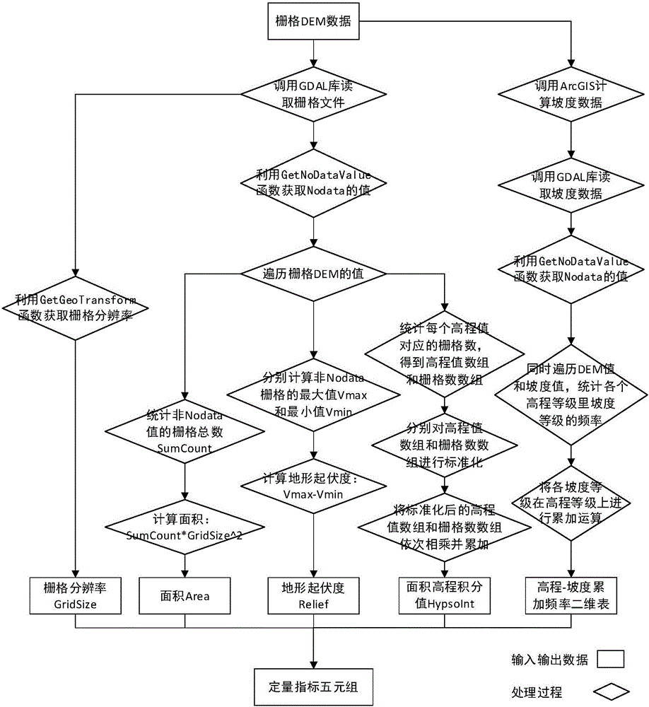
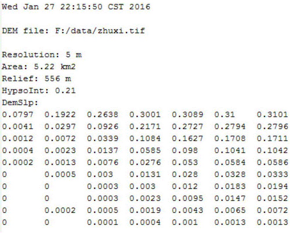
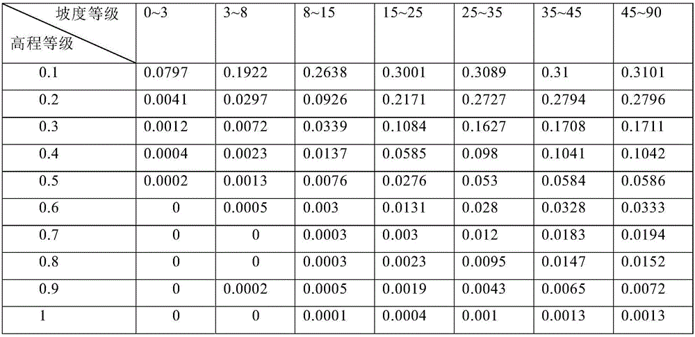
[0027] When describing the case problem of DTA modeling knowledge, in order to quantitatively describe the data characteristics of the case and the characteristics of the study area, the quantitative indicators used are: DEM grid resolution (considering that grid DEM is mainly used in current practical applications, this note Currently for grid DTA applications), area, terrain relief, slope distribution, and development characteristics. Among them, the DEM grid resolution is used to describe the data characteristics; the area, terrain relief, slope distribution, and development characteristics are four indicators used to describe the characteristics of the study area. The three indicators of grid resolution, area, and terrain relief are described by intuitive and commonly used single values; the slope and development characteristics are described by the elevation-slope cumulative frequency two-dimensional table and the area elevation integral curve, respectively. Among them, t...


PUM


Abstract

The invention relates to an automatic processing method for real-situation cases of DTA (Digital Terrain Analysis) modelling knowledge. The automatic processing method for the real-situation cases of the DTA modelling knowledge comprises the following steps of quantitatively expressing a research area applied by digital terrain analysis as a quintuple group which contains five quantitative indexes, namely, grid resolution, area, relief amplitude, elevation-slope cumulative frequency two-dimensional tables, and area elevation integral values; taking a grid DEM (Digital Elevation Model) as input data; automatically processing the above five quantitative indexes by calling a grid data reading function of an open source grid GDAL (Geospatial Data Abstraction Library) and part terrain factor calculating module of geographical information system software ArcGIS, wherein the obtained digital terrain analysis modelling knowledge cases can be used for performing quantitative evaluation on the availability of existing digital terrain analysis modelling knowledge in a certain research area in other research areas. According to the automatic processing method, human intervention is reduced, and technical support can be provided for the real-situation cases of the DTA modelling knowledge and applicable range speculation.

Description

technical field [0001] The invention relates to an automatic quantitative index processing method for case-based digital terrain analysis and modeling knowledge, and belongs to the technical field of application of digital terrain analysis based on case reasoning. Background technique [0002] Digital terrain analysis (DTA, Digital terrain analysis) is a digital information processing technology based on digital elevation model (DEM, Digital Elevation Model) for terrain attribute calculation and feature extraction. DTA application modeling is widely used in the field of physical geography. However, the DTA application modeling process is complex and involves a lot of DTA expertise. In practical applications, details such as algorithm selection and parameter setting often have a great impact on the running results of the entire model, and the model needs to be configured according to the region and data characteristics. Since the region and data characteristics themselves are...

Claims


Application Information

Patent Timeline
Patent Type & Authority Applications(China)
IPC IPC(8): G06F17/30G06F17/50
CPCG06F16/29G06F30/367Y02E60/00
Inventor 吴雪薇秦承志卢岩君朱阿兴
Owner INST OF GEOGRAPHICAL SCI & NATURAL RESOURCE RES CAS
Why Eureka
Try Eureka