Polygon-based main road selection method of urban road network

A polygon and main road technology, applied in the field of geographic information science, can solve the problems of low feasibility of polygon shape descriptors, no separate processing, difficulty in noise reduction of seed polygons, etc.

Active Publication Date: 2016-08-24
CHINA UNIV OF GEOSCIENCES (WUHAN)
View PDF4 Cites 11 Cited by
  • Summary
  • Abstract
  • Description
  • Claims
  • Application Information

AI Technical Summary

Problems solved by technology

However, the current polygon-based method also has some shortcomings: some polygon shape descriptors are less feasible in practical applications; the processing of different

Method used


Image

  • Polygon-based main road selection method of urban road network
  • Polygon-based main road selection method of urban road network
  • Polygon-based main road selection method of urban road network

Examples


Embodiment Construction

[0046] The present invention will be described in detail below in conjunction with specific examples, but the protection scope of the present invention is not limited to the following examples.

[0047] The whole process of this embodiment operates as follows:

[0048] Step 1: Data preprocessing;

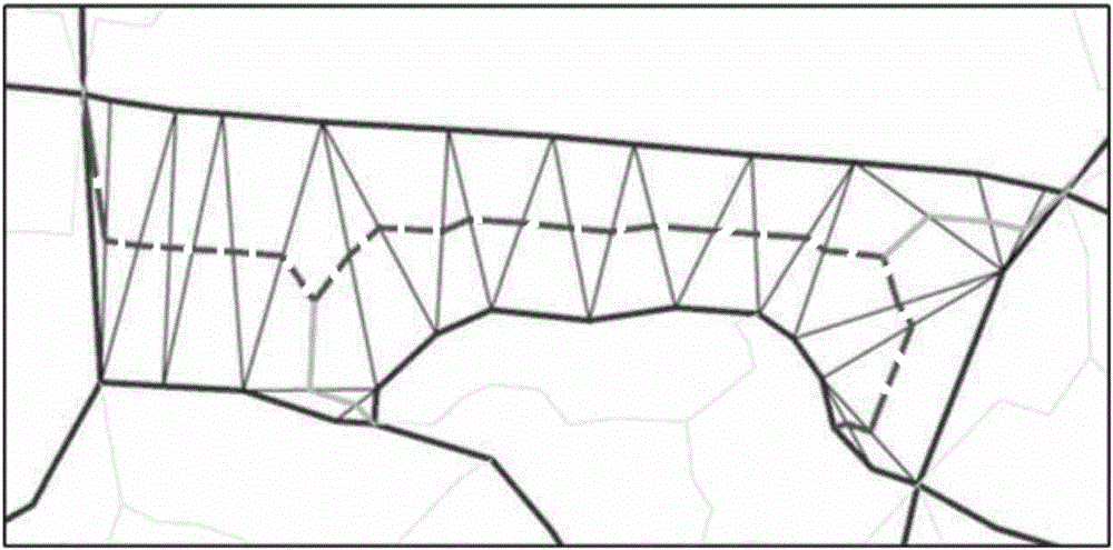
[0049] The present invention is based on the research carried out based on OpenStreetMap (OSM for short) map data as the data source, and selects the roads layer in the OSM of Munich, Germany as the test object. Due to the lack of professional and strict control of the original OSM data input, there are some problems in the quality of OSM data. For example, there are complex intersections between line elements of different road levels and the lack of consistency between the attributes of high-level road line elements. Therefore, we need to perform specific processing on these data in order to correctly generate areas. Here we use GIS software to complete , the specific operation i...


PUM


Abstract

The invention provides a polygon-based main road selection method of an urban road network. The polygon-based main road selection method comprises the following steps: firstly, taking OSM map data as a data source and processing to generate area elements; forming a four-dimensional vector by utilizing four shape descriptors including compactness, width, complexity and circularity, and describing polygons in road network data of the generated area element; marking particle polygons and extracting; classifying the obtained four-dimensional vectors by utilizing a non-linear SVM (Support Vector Machine) classification method, and extracting the corresponding polygons after classification; and combining the extracted particle polygons with the polygons obtained by SVM classification to form seed polygons. The invention provides the shape descriptors capable of relatively effectively describing the polygons of a main road, and the polygons with different shape characteristics of the main rod are processed respectively; and finally, based on topological characteristics among the polygons of the road network, the seed polygons extracted by a support vector machine are further processed to obtain the final main road polygons.

Description

technical field [0001] The invention relates to a method for selecting a main road of an urban road network based on polygons, which combines artificial intelligence, automatic synthesis of road network mapping, and selection of urban main roads, and belongs to the field of geographic information science. Background technique [0002] The automatic cartographic generalization of spatial data in digital environment is one of the core problems of modern cartography research. It is often a time-consuming and labor-intensive process to use large-scale digital map data to produce small-scale maps and to express multi-scale spatial data in geographic information systems. How to use automatic cartographic generalization methods to realize automatic conversion of data under different scales is the subject of extensive research today. In road network selection, the more common methods are link-based and road mesh-based. But these methods perform unsatisfactorily in the case of low ...

Claims


Application Information

Patent Timeline
IPC IPC(8): G06F17/50
CPCG06F30/18
Inventor 陈占龙谢忠吴亮胡宗哲徐永洋龚希叶文
Owner CHINA UNIV OF GEOSCIENCES (WUHAN)
Why Eureka
Try Eureka