An improved walking navigation method and system based on virtual reality
A technology of virtual reality and pedestrian navigation, applied in the field of navigation, can solve the problem that pedestrian navigation cannot meet the individual needs of users, and achieve the effect of increasing fun
- Summary
- Abstract
- Description
- Claims
- Application Information
AI Technical Summary
Problems solved by technology
Method used
Image
Examples
Embodiment Construction
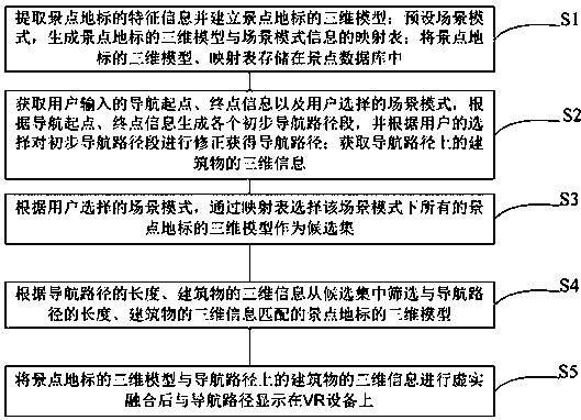
[0061] Such as figure 1 Shown, a kind of improved walking navigation method based on virtual reality, it comprises the following steps:
[0062] S1. Extract feature information of scenic spots and landmarks and build three-dimensional models of scenic spots and landmarks; preset scene mode, generate mapping tables of three-dimensional models of scenic spots and landmarks and scene mode information; store three-dimensional models and mapping tables of scenic spots and landmarks in scenic spots database.
[0063] The scenic spot landmark may be a famous mountain, a famous building, an artificial scenic spot, and the like. According to the characteristics of these landmarks, scene modes such as natural scenery, high-rise buildings, historical buildings, etc., can also be further divided in combination with the style of the building, such as European style, southern town, etc., can be pre-set.
[0064] S2. Obtain the navigation start point and end point information input by the u...
PUM
 Abstract
Description
Claims
Application Information
 - R&D
- Intellectual Property
- Life Sciences
- Materials
- Tech Scout
- Unparalleled Data Quality
- Higher Quality Content
- 60% Fewer Hallucinations
Browse by: Latest US Patents, China's latest patents, Technical Efficacy Thesaurus, Application Domain, Technology Topic, Popular Technical Reports.
© 2025 PatSnap. All rights reserved.Legal|Privacy policy|Modern Slavery Act Transparency Statement|Sitemap|About US| Contact US: help@patsnap.com


