Method and system for determining high-frequency regions for roadside stall business in urban streets

A street and city technology, applied in relational databases, structured data retrieval, instruments, etc., can solve problems such as low efficiency and high time complexity, and achieve the effect of reducing calculations, reducing complexity, and avoiding repeated queries

Inactive Publication Date: 2016-08-31
CHINA AGRI UNIV
View PDF4 Cites 3 Cited by
  • Summary
  • Abstract
  • Description
  • Claims
  • Application Information

AI Technical Summary

Problems solved by technology

[0004] The technical problem to be solved by the present invention is: the existing method for determining

Method used


Image

  • Method and system for determining high-frequency regions for roadside stall business in urban streets
  • Method and system for determining high-frequency regions for roadside stall business in urban streets
  • Method and system for determining high-frequency regions for roadside stall business in urban streets

Examples


Embodiment Construction

[0036] Embodiments of the present invention will be described in detail below with reference to the accompanying drawings.

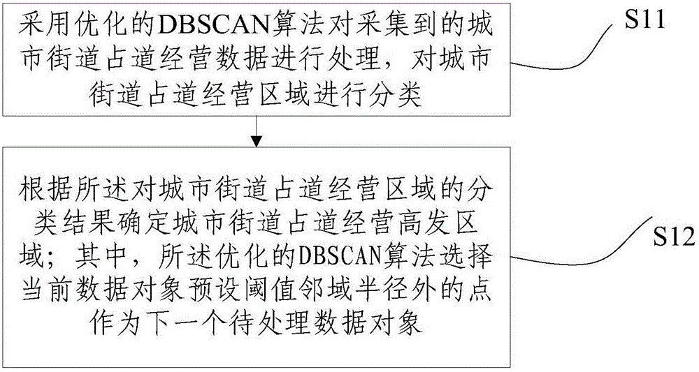
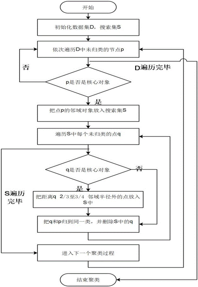
[0037] figure 1 It shows a schematic flowchart of a method for determining a high-incidence area of ​​urban street occupation operations according to an embodiment of the present invention. Such as figure 1 As shown, the method for determining the high-incidence areas of urban street occupation operations in this embodiment includes:

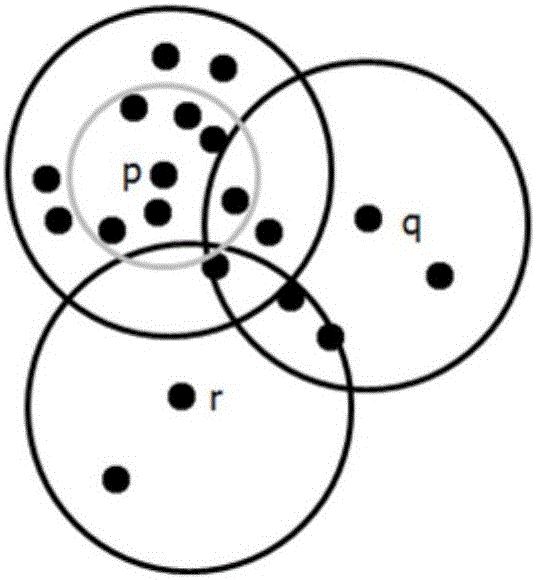
[0038] S11: Use the optimized DBSCAN algorithm to process the collected urban street occupation business data, and classify the urban street occupation business areas;

[0039] S12: Determine the high-incidence areas of urban street occupation operations according to the classification results of the urban street occupation operation areas;

[0040] Wherein, the optimized DBSCAN algorithm selects a point outside the neighborhood radius of the preset threshold value of the current data object as the next data object to b...


PUM


Abstract

The invention relates to a method and system for determining high-frequency regions for roadside stall business in urban streets. The method comprises following steps: utilizing an optimized DBSCAN algorithm to process acquired data of roadside stall business in urban streets and classifying regions for roadside stall business in urban streets; and determining high-frequency regions for roadside stall business in urban streets based on classification results of regions for roadside stall business, wherein the optimized DBSCAN algorithm is used for selecting a point outside of the neighbor radius for pre-set threshold value of a current data object as a next data object to be processed. The method and system for determining high-frequency regions for roadside stall business in urban streets have following beneficial effects: the optimized DBSCAN algorithm is adopted to select the point outside of the neighborhood radius for pre-set threshold value of the current data object as the next data object to be processed; repeated search of objects in public neighborhood is avoided; calculations of neighborhood search for core objects are reduced; complexity of the algorithm is decreased; and determination efficiency of high-frequency regions for roadside stall business in urban streets can be increased for providing information and making decisions for urban management work.

Description

technical field [0001] The invention relates to the technical field of spatial data mining, in particular to a method and a system for determining areas with high incidence of road occupation and operation in urban streets. Background technique [0002] With the rapid development of economy and society, the phenomenon of illegal operation in cities all over the country has been banned repeatedly and it is difficult to cure it. This directly affects the improvement of urban civilization and the quality of life of the surrounding people. In the work of city appearance and environment, road occupation management has become a major chronic disease in the management of city appearance and environmental sanitation. Governments at all levels and functional departments have adopted various means for governance, but with little success. Spatial data mining refers to the process of extracting general knowledge rules of space or non-spatial that are unknown in advance, potentially use...

Claims


Application Information

Patent Timeline
IPC IPC(8): G06F17/30
CPCG06F16/285G06F16/29
Inventor 彭波史春雷张磊
Owner CHINA AGRI UNIV
Why Eureka
Try Eureka