

Method for precisely drawing coast line on satellite cloud picture
A technology of satellite cloud images and coastlines, which is applied in the field of meteorological satellite cloud image processing, and can solve problems such as imperfect images and mapping
- Summary
- Abstract
- Description
- Claims
- Application Information
AI Technical Summary
Problems solved by technology
Method used
Image

Examples
Embodiment Construction
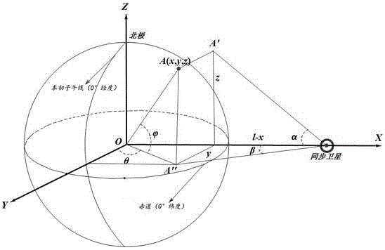
[0037] The technical solution of the present invention is to design a method for accurately drawing the coastline on a satellite cloud image. In order to describe the technical solution of the invention more clearly, the specific embodiments of the present invention will be further elaborated below in conjunction with the accompanying drawings. Obviously, the following description The embodiments are only some embodiments, not all embodiments. According to the embodiments of the present invention, those skilled in the art can realize all other embodiments of the present invention without creative efforts, which all belong to the protection scope of the present invention.
[0038] Step 1: If figure 1 The Cartesian coordinate system is established as shown, and the equation is satisfied according to the spatial geometric relationship:
[0039] y = t a n β ( l - ...
PUM
 Abstract
Description
Claims
Application Information