Navigation route planning method and device

A technology for navigation routes and routes, applied in the field of navigation, can solve problems such as unreasonable local planning of navigation routes, and achieve the effect of improving practicability and accuracy and reducing wasted time.

Active Publication Date: 2016-12-14
BAIDU ONLINE NETWORK TECH (BEIJIBG) CO LTD
View PDF5 Cites 44 Cited by
  • Summary
  • Abstract
  • Description
  • Claims
  • Application Information

AI Technical Summary

Problems solved by technology

[0005] In view of this, the embodiments of the present invention provide a navigation route planning method and device to solve the technical problem of unreasonable partial planning of navigation routes in the prior art

Method used


Image

  • Navigation route planning method and device
  • Navigation route planning method and device
  • Navigation route planning method and device

Examples


Embodiment 1

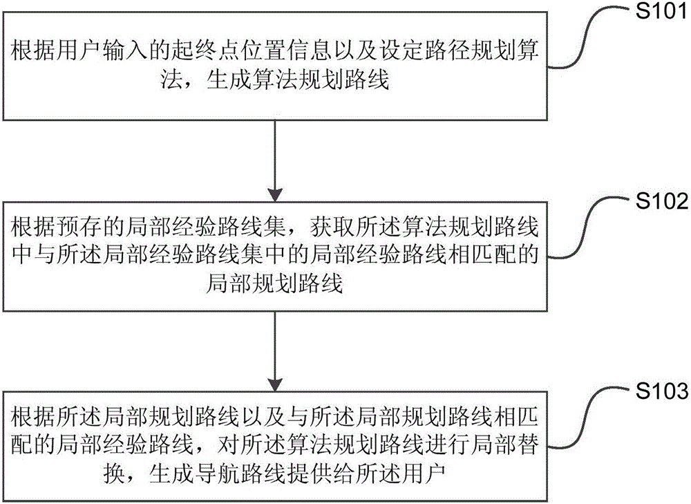
[0024] Embodiment 1 of the present invention provides a navigation route planning method. The method can be executed by a navigation route planning device, wherein the device can be implemented by software and / or hardware, and generally can be integrated in a server corresponding to the navigation client. figure 1 It is a schematic flowchart of the navigation route planning method provided in Embodiment 1 of the present invention. like figure 1 As shown, the method includes:

[0025] S101. Generate an algorithm-planned route according to the starting and ending location information input by the user and setting the route planning algorithm.

[0026] Exemplarily, the user's starting point location information can be obtained directly through GPS positioning, or can be obtained through the user's input operation; the user's end point location information can be obtained through the user's input operation. Here, the user's input can be either the user's manual input or the use...

Embodiment 2

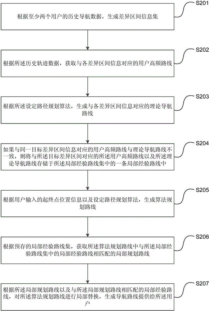
[0036] figure 2 It is a schematic flowchart of a navigation route planning method provided by Embodiment 2 of the present invention. This embodiment is optimized on the basis of the above-mentioned embodiments. Further, the navigation route planning method provided by the embodiment of the present invention further includes: According to the historical navigation data of at least two users, a difference interval information set is generated, wherein the difference interval information includes the interval start road section identification and the interval end section identification of the difference between the user's actual trajectory data and the corresponding navigation route; according to the history Trajectory data, obtain user high-frequency routes corresponding to each difference interval information; according to the set route planning algorithm, generate theoretical navigation routes corresponding to each difference interval information; if the user high-frequency ro...

Embodiment 3

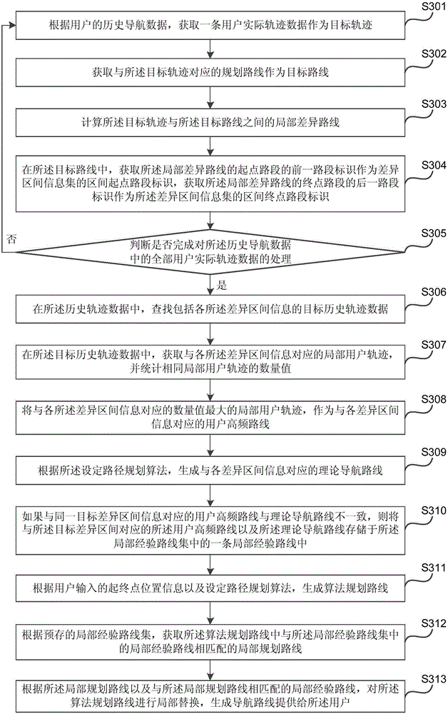
[0056] image 3 It is a schematic flowchart of a navigation route planning method provided by Embodiment 3 of the present invention. This embodiment is optimized on the basis of the above embodiments. Further, a difference interval information set is generated according to the historical navigation data of at least two users The method includes: obtaining a piece of user actual trajectory data as a target trajectory according to the user's historical navigation data; obtaining a planned route corresponding to the target trajectory as the target route; calculating a local difference route between the target trajectory and the target route; In the target route, obtain the previous section identifier of the starting section of the partial difference route as the section starting section identification of the difference section information set, and acquire the subsequent section identification of the end section of the local difference course as the difference The interval end roa...


PUM


Abstract

The embodiment of the invention discloses a navigation route planning method and device. The method comprises the steps that an algorithm planning route is generated according to starting point and terminal point position information input by a user and a set route planning algorithm; a partial planning route matched with a partial experience route in a partial experience route set in the algorithm planning route is acquired according to the preset partial experience route set; the algorithm planning route is partially replaced according to the partial planning route and the partial experience route matched with the partial planning route, and a navigation route is generated and provided for the user. According to the navigation route planning method and device, by means of the technical scheme, the partial unreasonable route existing in the algorithm planning route is adjusted according to the pre-stored partial experience route, therefore, the defects existing in the navigation route acquired through a traditional algorithm can be overcome, the unreasonable route existing in the navigation route is corrected, the practicability and the precision of the navigation route are improved, and the time that the user consumes due to the unreasonable navigation route can be reduced.

Description

technical field [0001] The invention relates to the technical field of navigation, in particular to a planning method and device for a navigation route. Background technique [0002] With the continuous development of positioning technology and the increasing popularity of the Global Positioning System (GPS), more and more users begin to obtain route planning information when driving or walking through navigation terminals, and usually follow the route planning information to Determine your own driving or walking route. [0003] At present, navigation terminals mostly use the shortest path planning algorithm to realize the planning of the navigation route, that is, the distance or time is used as the weight of the directed weighted graph, and the shortest path algorithm is used, such as Dijkstra's Algorithm (Dijkstra's Algorithm) , to solve the shortest route, and find out one or the first few routes with the smallest weight, so as to plan one or several reasonable routes f...

Claims


Application Information

Patent Timeline
Patent Type & Authority Applications(China)
IPC IPC(8): G01C21/34
CPCG01C21/3446G01C21/3484
Inventor 李锐
Owner BAIDU ONLINE NETWORK TECH (BEIJIBG) CO LTD
Why Eureka
Try Eureka