Multi-unmanned aerial vehicle traversal search algorithm based on sub-region division

A sub-area division and search algorithm technology, applied in the field of multi-UAV traversal search algorithm, can solve the problems of lower search efficiency, complex segmentation, and failure to achieve the best of the whole area, so as to improve search efficiency, avoid repeated searches, and realize simple effect

Inactive Publication Date: 2017-01-04
HARBIN INST OF TECH SHENZHEN GRADUATE SCHOOL
View PDF2 Cites 48 Cited by
  • Summary
  • Abstract
  • Description
  • Claims
  • Application Information

AI Technical Summary

Problems solved by technology

(2) Region division algorithm based on Voronoi diagram: use the characteristics of Voronoi diagram and combine the actual region shape to divide the search region (3) The region division algorithm based on the minimum sum of subregion widths requires the minimum width of subregions, It is also necessary to ensure that the sum of all sub-region widths is the smallest, so the algorithm is more complicated to implement
[0010] 3. Problems faced by UAV trajectory planning
[0013] 4. Inadequacies of existing sub-region division algorithms
[0014] In the existing sub-area division algorithm, the method of using Voronoi diagram to segment the search area is very common, but this segmentation is very complicated and has uncertainty, which requires high autonomy of the UAV; while the Boustrophedon area Although the division algorithm is not complex and can be applied to single-machine and multi-machine area division at the same time, it has requirements for the direction of division and cannot reach the optimal level of the whole area.
The division algorithm based on the minimum sum of sub-region widths also faces the problem of high algorithm complexity. In addition, the sub-regions divided by this algorithm are of different areas, which easily leads to repeated search of the region. In addition, the number of divided sub-regions is also relatively large. This patent has many divisions, resulting in a lot of wasted search resources when connecting drone sub-areas, reducing search efficiency

Method used


Image

  • Multi-unmanned aerial vehicle traversal search algorithm based on sub-region division
  • Multi-unmanned aerial vehicle traversal search algorithm based on sub-region division
  • Multi-unmanned aerial vehicle traversal search algorithm based on sub-region division

Examples


Embodiment Construction

[0045] The present invention will be further described below with reference to the accompanying drawings and specific embodiments.

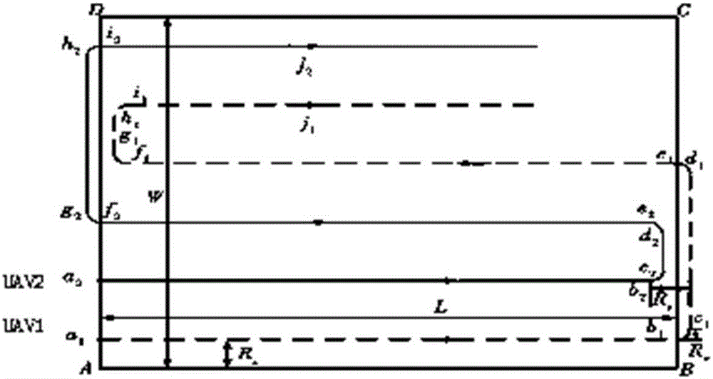
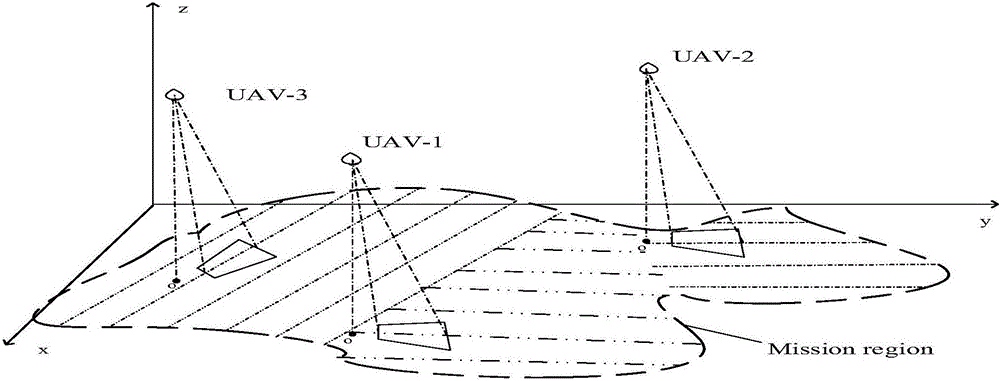
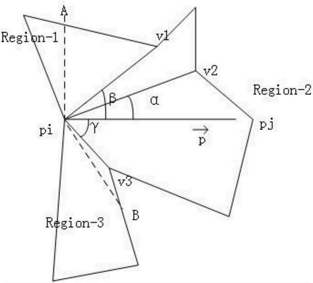
[0046] The existing Boustrophedon division algorithm, Exact Cell Decomposition and Templates matching region division algorithms have certain restrictions on the shape of polygonal regions, and are not suitable for all situations; and based on the sum of the widths of subregions The sub-regions divided by the sub-regional division algorithm have a large difference in shape, which is not conducive to the trajectory planning of the UAV, and the algorithm complexity is high. Therefore, in view of the shortcomings of the above algorithms, this patent proposes a multi-UAV search algorithm based on sub-region division and track length. When the search area is an irregular polygon, the figure 2 As shown in the multi-UAV search diagram as an example, firstly, the entire area is divided into multiple sub-areas with good shape and little difference by us...


PUM


Abstract

The invention relates to the field of unmanned aerial vehicle algorithm calculating, in particular to a multi-unmanned aerial vehicle traversal search algorithm based on sub-region division. According to the designed multi-unmanned aerial vehicle traversal search algorithm based on sub-region division, a specific region division mode and a multi-unmanned aerial vehicle route planning and task allocating mode are given, and a practical and feasible scheme is provided for unmanned aerial vehicle traversal searching. It is verified that the algorithm is valid through a specific algorithm generating living example, no special demand is needed for the shape of a searching region, and the algorithm is suitable for multiple irregular regions and has the universality. Compared with other division algorithms, the region division algorithm has the advantages that achievement is easy, repeated searching of unmanned aerial vehicles can be effectively avoided, the consumed time of the unmanned aerial vehicles during sub-region connection is shortened, and a larger region can be searched for under the condition of the same property and number of the unmanned aerial vehicles.

Description

technical field [0001] The invention relates to the field of unmanned aerial vehicle algorithm calculation, in particular to a multi-unmanned aerial vehicle traversal search algorithm based on sub-area division. Background technique [0002] 1. UAV track planning [0003] Unmanned aerial vehicles have the characteristics of small size, low price, and flexible maneuverability. They are playing an increasingly important role in modern military, environmental monitoring, and disaster prevention and control. UAV trajectory planning is of great significance to improve the survivability and task execution ability of UAV. At present, the existing trajectory planning technology is mainly divided into the following two types: [0004] 1) "Point-to-Point" Path Planning ('Point-to-Point' Path Planning) [0005] "Point-to-point" track planning refers to finding the optimal flight route of the UAV from the starting point to the target point in a certain environment, avoiding all threa...

Claims


Application Information

Patent Timeline
Patent Type & Authority Applications(China)
IPC IPC(8): G01C21/20
CPCG01C21/20G05D1/104
Inventor 杨志华荆莹廖小丽金豪杰
Owner HARBIN INST OF TECH SHENZHEN GRADUATE SCHOOL
Why Eureka
Try Eureka