Space network construction and path planning method for indoor and underground space navigation

A space network and path planning technology, applied in surveying and mapping, navigation, navigation, navigation computing tools, etc., can solve problems such as low efficiency

Inactive Publication Date: 2017-02-15
HENAN POLYTECHNIC UNIV
View PDF3 Cites 12 Cited by
  • Summary
  • Abstract
  • Description
  • Claims
  • Application Information

AI Technical Summary

Problems solved by technology

[0007] This patent is based on this, and for complex indoor and underground spaces involving multiple interconnected horizontal spaces, it provides an integrated three-dimensional road network data set construction method fo...

Method used


Image

  • Space network construction and path planning method for indoor and underground space navigation
  • Space network construction and path planning method for indoor and underground space navigation
  • Space network construction and path planning method for indoor and underground space navigation

Examples


Embodiment Construction

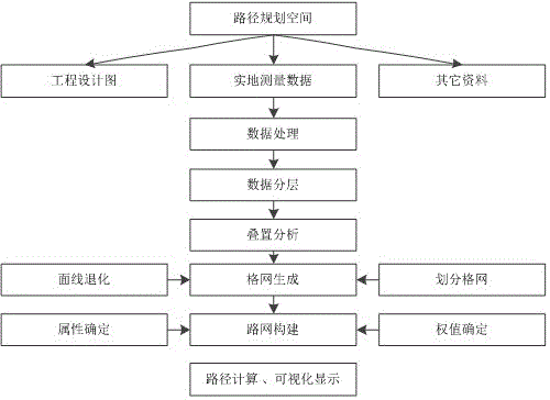
[0026] A spatial network construction and path planning method for indoor and underground space navigation, the method comprising the following steps:

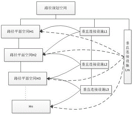
[0027] Step 1: Obtain the plan design drawing of the route planning space, and combine the field measurement method to correct the spatial elements that do not conform to the design, divide the planning space into different horizontal planes, and divide the data into spatial data of different horizontal planes;

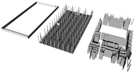
[0028] Step 2: According to the function of spatial data in the road network, divide the spatial data of each horizontal plane into its category. Objects of fixed obstacles in building structures: belong to long-term stable spatial elements; Objects of non-structural and movable obstacles: temporary partitions and movable dynamic elements; two types of spatial elements are extracted respectively to form a fixed obstacle and a dynamic obstacle spatial element layer;

[0029] Step 3: Processing of fixed obstacle spatial...


PUM


Abstract

The invention relates to a space network construction and path planning method for indoor and underground space navigation. According to the method, route planning space is divided into space in different horizontal planes, then grids with a certain resolution rate are formed according to a certain rule, then the grids are connected through corresponding channels to form an integrated three-dimensional route planning spatial network, and finally candidate planned routes are obtained from the spatial network. The construction of spatial network comprises steps of spatial data processing, obstruction and obstacle element extraction, and integrated spatial network formation. The method is suitable for planning routes in different horizontal planes for large indoor space and complicated underground space, can generate route planning spatial stereo networks, establish dynamic road networks, and plan routes, and displays corresponding road networks and route planning results on an indoor map.

Description

technical field [0001] The invention belongs to the field of indoor and underground navigation, and relates to a space network structure and path planning method for indoor and underground space navigation, which is used to establish a three-dimensional space road network model and a navigation path planning method using acquired engineering design and measurement data . Background technique [0002] At present, electronic map services are mainly aimed at outdoor areas, and related map products are relatively mature. Representative products include map service solutions such as Baidu, Google, SuperMap, and ArcGIS. In terms of map positioning and navigation applications, electronic maps and outdoor global navigation and positioning The extensive combination of technologies provides great convenience for people's daily travel. [0003] With the rapid advancement of urbanization and the rapid development of the commercial economy, the interior and underground engineering struc...

Claims


Application Information

Patent Timeline
IPC IPC(8): G01C21/00G01C21/20
CPCG01C21/00G01C21/206
Inventor 葛小三孙小兰郭婧筠马勇王华伟
Owner HENAN POLYTECHNIC UNIV
Why Eureka
Try Eureka