
Ground PM2.5 inversion method and system based on satellite remote sensing

A satellite remote sensing and ground technology, applied to instruments, electrical digital data processing, climate sustainability, etc., can solve the problems of low accuracy, achieve the effects of improving accuracy, flexible inversion, and improving estimation accuracy

Inactive Publication Date: 2017-02-22
INST OF REMOTE SENSING & DIGITAL EARTH CHINESE ACADEMY OF SCI
View PDF0 Cites 28 Cited by
  • Summary
  • Abstract
  • Description
  • Claims
  • Application Information

AI Technical Summary

Problems solved by technology

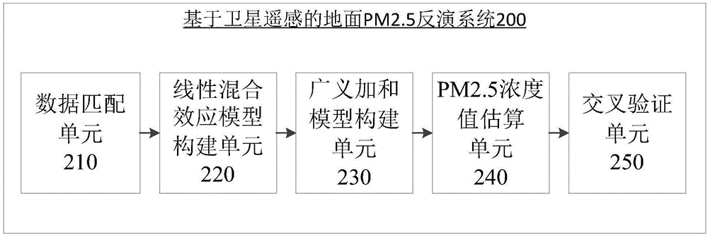
[0008] In view of the problems referred to above, the object of the present invention is to provide a ground PM2.5 inversion method and system based on satellite remote sensing, to solve the problem that existing advanced statistical models have low precision when inverting ground PM2.5

Method used


Image

  • Ground PM2.5 inversion method and system based on satellite remote sensing
  • Ground PM2.5 inversion method and system based on satellite remote sensing

Examples


Embodiment Construction

[0026] Specific embodiments of the present invention will be described in detail below in conjunction with the accompanying drawings.

[0027] Aiming at the problem that the aforementioned existing advanced statistical models have low precision in estimating the concentration of ground PM2.5, the present invention can effectively improve the ground PM2. 5 estimated accuracy.

[0028] Before describing the present invention, the concepts and terms involved in the present invention will be described first.

[0029] In the present invention, the satellite remote sensing AOD product of the sixth edition (C6) of the MODerate-resolution Imaging Spectroradiometer (MODIS) on the NASA Aqua satellite is used. The data in this product uses dark target algorithm (DT) and deep blue algorithm (DB) to extract satellite AOD data and perform inverse variance weighted fusion to construct and invert the national scale PM2.5 concentration distribution in my country. Among them, in the present i...


PUM


Abstract

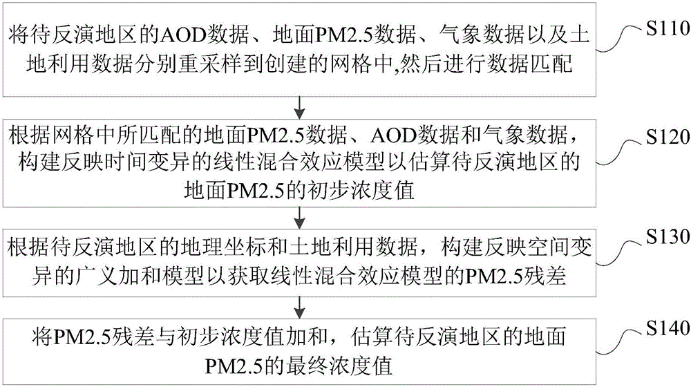
The invention provides a ground PM2.5 inversion method and system based on satellite remote sensing. The method includes: resampling AOD data, ground PM2.5 data, meteorological data and land use data of a to-be-inverted area respectively into a created grid to conduct data matching; according to the matched ground PM2.5 data, AOD data and meteorological data in the grid, and constructing a linear mixed effect model reflecting time variation to estimate an initial concentration value of ground PM2.5 in the to-be-inverted area; according to the geographical coordinates and land use data of the to-be-inverted area, constructing a generalized addition model reflecting spatial variability to acquire a PM2.5 residual error of the linear mixed effect model; subjecting the PM2.5 residual error and the initial concentration value to addition, and estimating a final concentration value of ground PM2.5 at the to-be-inverted area. The method and the system provided by the invention can effectively improve the estimation precision of ground PM2.5 concentration.

Description

technical field [0001] The invention relates to the technical field of aerosol monitoring, and more specifically, relates to a ground PM2.5 retrieval method and system based on satellite remote sensing. Background technique [0002] PM2.5 refers to particulate matter in the air with an aerodynamic particle size of less than 2.5 microns. Compared with large-size particles, PM2.5 has a small particle size, is rich in a large amount of toxic and harmful substances, has a long residence time in the atmosphere, and has a long transportation distance, so it has a great impact on the quality of the human body and the atmospheric environment. A large number of epidemiological studies abroad have proved that PM2.5 is related to negative health effects, such as increasing the morbidity and mortality of cardiovascular and respiratory diseases. [0003] Among them, the research on the health effects of PM2.5 needs the support of long-term and large-scale PM2.5 exposure data. The use o...

Claims


Application Information

Patent Timeline
IPC IPC(8): G01N15/06G06F19/00
CPCY02A90/10
Inventor 刘阳马宗伟毕军陈良富陶金花李莘莘王子峰
Owner INST OF REMOTE SENSING & DIGITAL EARTH CHINESE ACADEMY OF SCI
Learn More