MB-RRT-based unmanned aerial vehicle two-dimensional track planning method

A technology for trajectory planning and unmanned aerial vehicles, which is applied in two-dimensional position/channel control, non-electric variable control, instruments, etc., and can solve the problems of large memory footprint, poor practicability, and small memory footprint.

Active Publication Date: 2017-02-22
ZHEJIANG UNIV OF TECH
View PDF5 Cites 41 Cited by
  • Summary
  • Abstract
  • Description
  • Claims
  • Application Information

AI Technical Summary

Problems solved by technology

[0009] In order to overcome the deficiencies of the existing two-dimensional trajectory planning methods for unmanned aerial vehicles, such as slow convergence speed, large memory usage, limited growth near obstacles, and poor practicability, the present invention provides a fast convergence speed , The memory footprint is small, the problem of limited growth near obstacles is solved, and the MB-RRT*-based UAV two-dimensional trajectory planning method can be directly applied to UAV control

Method used


Image

  • MB-RRT-based unmanned aerial vehicle two-dimensional track planning method
  • MB-RRT-based unmanned aerial vehicle two-dimensional track planning method
  • MB-RRT-based unmanned aerial vehicle two-dimensional track planning method

Examples


Embodiment Construction

[0060] The present invention will be further described below in conjunction with the accompanying drawings.

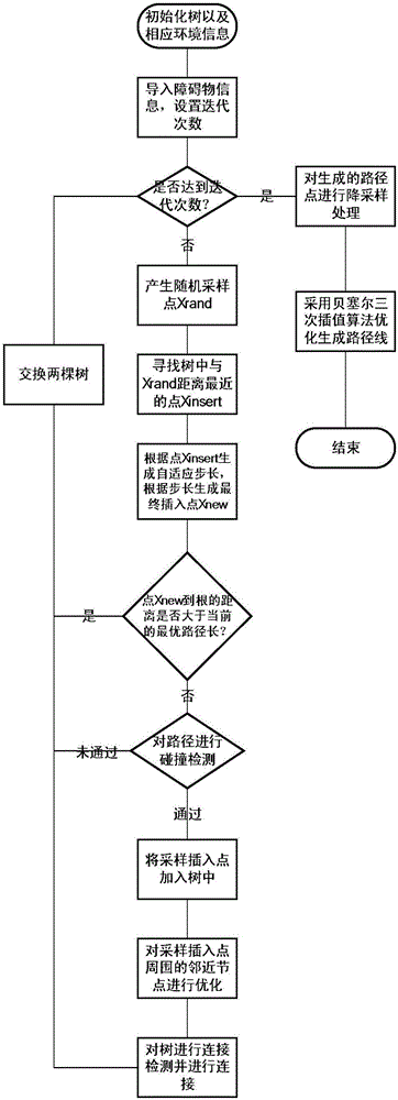
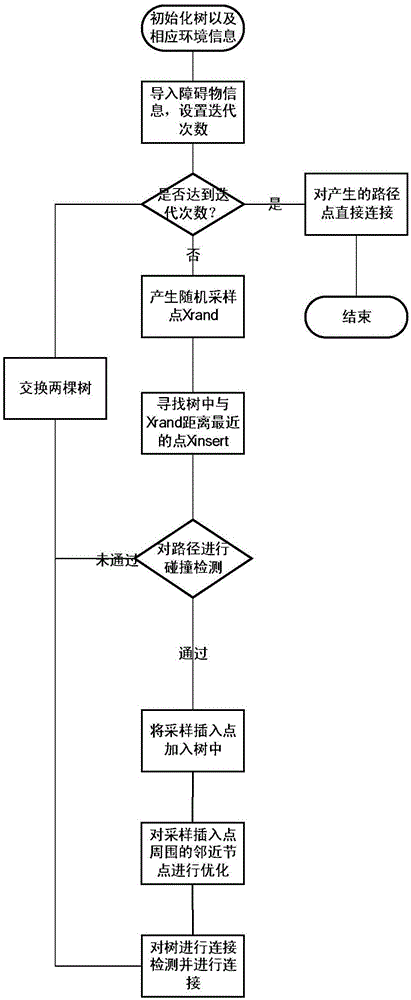
[0061] refer to Figure 1 to Figure 10 , a method for two-dimensional trajectory planning of UAV based on MB-RRT*, including the following steps:

[0062] 1) Initialize tree and environment information;

[0063] 2) Import obstacle information and set the number of iterations;

[0064] 3) Judging whether the number of iterations has been reached, if so, down-sampling the generated path points, and adopting an interpolation algorithm to optimize the generated path line, and ending; otherwise, enter 4);

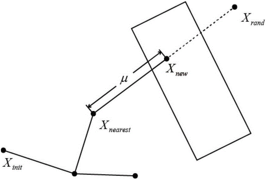
[0065] 4) Generate a random sampling point Xrand, and find the point Xinsert closest to the random sampling point Xrand in the tree;

[0066] 5) Generate an adaptive step size according to the point Xinsert, and generate the final insertion point Xnew according to the step size;

[0067] 6) Judging whether the distance from the insertion point Xnew to the root of the...


PUM


Abstract

The invention discloses an MB-RRT-based unmanned aerial vehicle two-dimensional track planning method, comprising the steps of initializing a tree and environmental information; importing obstacle information, and setting a number of iterations; judging whether the number of iterations is arrived, if so, performing down-sampling on the generated path point and optimizing the generated path line by adopting an interpolation algorithm; otherwise, generating a random sampling point, looking for a point nearest to the random sampling point in the tree, generating an adaptive step length according to the point, generating a final interpolation point according to the step length, judging whether the distance between the interpolation point and the root is greater than the current optimal path length, if not, performing collision detection on the path, adding the interpolation point to the tree and optimizing adjacent nodes around the interpolation point; if not, performing connection detection and connection on the tree. The method is high in convergence rate and small in memory occupation space, solves the problem of limitation of growth nearby an obstacle, and can be directly applied to unmanned aerial vehicle control.

Description

technical field [0001] The invention relates to a two-dimensional track planning method for an unmanned aerial vehicle. Background technique [0002] Large path planning is an important problem in UAV navigation and robotics. Path planning can be defined as: given an initial state and a target state, finding a feasible path for the UAV to run from the initial state to the target state without collision. Path planning has a wide range of application scenarios: GPS navigation, driverless cars, computer animation, routing problems, robotic arm motion in manufacturing industries and life, and many aspects of industrial fields. Therefore, the research on path planning has become a hot research topic in recent years. [0003] The UAV two-dimensional track planning algorithm can be divided into local path planning and global path planning according to its perception ability. The global path planning is to plan in the case of a known environmental map and know the global informati...

Claims


Application Information

Patent Timeline
Patent Type & Authority Applications(China)
IPC IPC(8): G05D1/02
CPCG05D1/0202
Inventor 陈晋音施晋杜文耀
Owner ZHEJIANG UNIV OF TECH
Why Eureka
Try Eureka